Property Record
220 Main St, Terryville, CT 06786
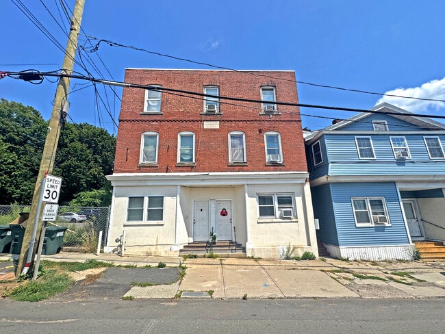

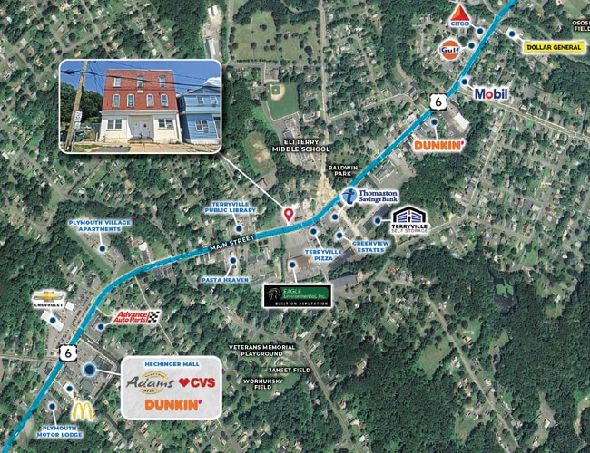
Property Detail
220 Main St
PLYM-000040-000053-000028
Naugatuck Vly
Apartmenthouse5plusunits
Connecticut
C
28
2025
0.05 AC
2025
Litchfield County
425300
Hartford
3,816 SF
Torrington, CT
NEARBY LISTINGS FOR SALE OR LEASE
-
-
View all Terryville listings for sale on LoopNet.com
DEMOGRAPHICS near 220 Main St
1 mile
3 mile
5 mile
2025 Total Population
5,459
21,067
65,918
2030 Population
5,562
21,657
67,723
Pop Growth 2025-2030
+ 1.89%
+ 2.80%
+ 2.74%
Average Age
43
43
42
2025 Total Households
2,374
8,712
26,911
HH Growth 2025-2030
+ 1.81%
+ 2.73%
+ 2.74%
Median Household Inc
$80,144
$98,680
$87,145
Avg Household Size
2.30
2.40
2.40
2025 Avg HH Vehicles
2.00
2.00
2.00
Median Home Value
$240,308
$289,176
$293,804
Median Year Built
1961
1973
1967
Nearby Places
Map Layers
Map Styles
 Street
 Aerial
Layers
 Traffic
 Biking
Places
Listings with unknown addresses are not visible on the map
- Restaurants
- Banks
- Shops
- Fitness
- Groceries
PUBLIC TRANSPORTATION
AIRPORT
Bradley International
Drive
Walk
Distance
Bradley International
60 min
34.2 mi
Tweed/New Haven
Drive
Walk
Distance
Tweed/New Haven
54 min
36.6 mi
SALE & LEASE HISTORY
LISTING DATE
SALE/LEASE

Sep 29, 2025
For Sale
Sep 27, 2022
For Sale
Sep 24, 2016
For Sale
Sep 01, 2017
For Sale
Nov 07, 2016
For Sale
Jan 05, 2022
For Sale
Feb 17, 2019
For Sale
Dec 12, 2017
For Sale
Nearby Properties
Address
Land Use
TOTAL SIZE
Lot Size
Zoning
Address
Land Use
TOTAL SIZE
Lot Size
Zoning
139 AC
IP-25
Address
Land Use
TOTAL SIZE
Lot Size
Zoning
121,917 SF
28.60 AC
R-15
Address
Land Use
TOTAL SIZE
Lot Size
Zoning
171,826 SF
36.60 AC
R-15
Address
Land Use
TOTAL SIZE
Lot Size
Zoning
169,727 SF
23.90 AC
R-25
Address
Land Use
TOTAL SIZE
Lot Size
Zoning
3.35 AC
RA2
Address
Land Use
TOTAL SIZE
Lot Size
Zoning
45,377 SF
91.90 AC
R-40
Address
Land Use
TOTAL SIZE
Lot Size
Zoning
49,977 SF
15.56 AC
R-25
Address
Land Use
TOTAL SIZE
Lot Size
Zoning
205,964 SF
14.35 AC
IP-3
Address
Land Use
TOTAL SIZE
Lot Size
Zoning
27,216 SF
3.80 AC
R-15/R
Address
Land Use
TOTAL SIZE
Lot Size
Zoning
2,464 SF
104.60 AC
R-40
Address
Land Use
TOTAL SIZE
Lot Size
Zoning
34.36 AC
RA2
Address
Land Use
TOTAL SIZE
Lot Size
Zoning
10 AC
RA1
Address
Land Use
TOTAL SIZE
Lot Size
Zoning
2.77 AC
C
Address
Land Use
TOTAL SIZE
Lot Size
Zoning
3.99 AC
RA1
Address
Land Use
TOTAL SIZE
Lot Size
Zoning
99,750 SF
9.10 AC
IP-3
Address
Land Use
TOTAL SIZE
Lot Size
Zoning
22,938 SF
1.92 AC
M
Address
Land Use
TOTAL SIZE
Lot Size
Zoning
953.93 AC
RA1
Address
Land Use
TOTAL SIZE
Lot Size
Zoning
4.30 AC
RA2
Address
Land Use
TOTAL SIZE
Lot Size
Zoning
4,366 SF
4.90 AC
R-15
Address
Land Use
TOTAL SIZE
Lot Size
Zoning
94,414 SF
6.50 AC
M
Address
Land Use
TOTAL SIZE
Lot Size
Zoning
11.25 AC
RA2
Address
Land Use
TOTAL SIZE
Lot Size
Zoning
1.82 AC
R-25
Address
Land Use
TOTAL SIZE
Lot Size
Zoning
53,240 SF
8.40 AC
IP-3
Address
Land Use
TOTAL SIZE
Lot Size
Zoning
49,690 SF
3.59 AC
M
Address
Land Use
TOTAL SIZE
Lot Size
Zoning
2.22 AC
M
Address
Land Use
TOTAL SIZE
Lot Size
Zoning
2.10 AC
C
Address
Land Use
TOTAL SIZE
Lot Size
Zoning
7.03 AC
C
Address
Land Use
TOTAL SIZE
Lot Size
Zoning
6.10 AC
M
Address
Land Use
TOTAL SIZE
Lot Size
Zoning
3.96 AC
RA2
Address
Land Use
TOTAL SIZE
Lot Size
Zoning
130,374 SF
10.50 AC
M2
The World's #1 Commercial Real Estate Marketplace
Connect with us
© 2026 CoStar Group
The information above has been obtained from sources believed reliable. While we do not doubt its accuracy we have not verified it and make no guarantee, warranty or representation about it. It is your responsibility to independently confirm its accuracy and completeness. Any projections, opinions, assumptions, or estimates used are for example only and do not represent the current or future performance of the property. The value of this transaction to you depends on tax and other factors which should be evaluated by your tax, financial, and legal advisors. You and your advisors should conduct a careful, independent investigation of the property to determine to your satisfaction the suitability of the property for your needs.