Property Record
220 Main Street Loop, Kenai, AK 99611


Save to a Folder
{{folder.Name}}
{{folder.ListingIds.length}} Properties
{{folder.ListingIds.length}} Property
Create a New Folder
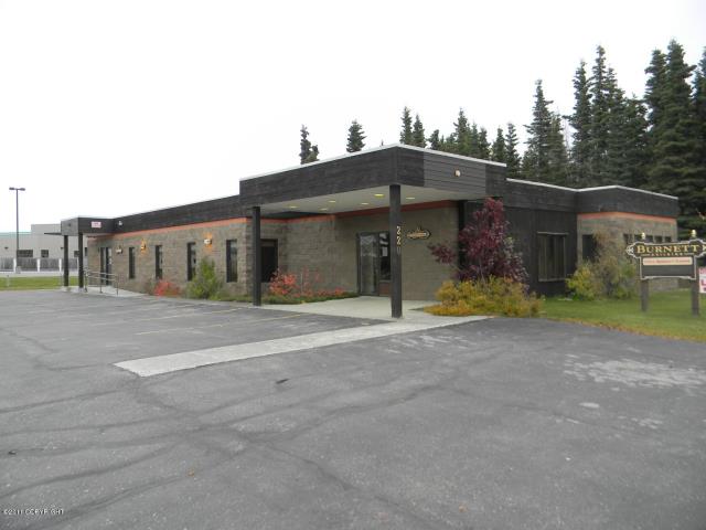
Property Detail
220 Main Street Loop
043-230-29
T 6N R 11W SEC 32 SEWARD MERIDIAN KN 0001448 COOK INLET INDUSTRIAL AIR PARK SUB LOT 7 BLOCK 1
Commercialnec
Kenai Peninsula
B and X Area of moderate flood hazard, usually the area between the limits of the 100-year and 500-year floods.
Alaska
2024
7
2025
0.40 AC
000600
Alaska Regional
4,154 SF
Other Market Areas
NEARBY LISTINGS FOR SALE OR LEASE
DEMOGRAPHICS near 220 Main Street Loop
1 mile
3 mile
5 mile
2025 Total Population
1,884
8,436
12,735
2030 Population
2,005
8,998
13,489
Pop Growth 2025-2030
+ 6.42%
+ 6.66%
+ 5.92%
Average Age
39
38
39
2025 Total Households
780
3,374
4,976
HH Growth 2025-2030
+ 6.54%
+ 6.73%
+ 6.05%
Median Household Inc
$60,903
$69,865
$72,950
Avg Household Size
2.30
2.40
2.40
2025 Avg HH Vehicles
2.00
2.00
2.00
Median Home Value
$256,927
$258,576
$275,509
Median Year Built
1987
1989
1989
Nearby Places
Map Layers
Map Styles
 Street
 Aerial
Layers
 Traffic
 Biking
Places
Listings with unknown addresses are not visible on the map
- Restaurants
- Banks
- Shops
- Fitness
- Groceries
PUBLIC TRANSPORTATION
AIRPORT
Kenai Municipal
Drive
Walk
Distance
Kenai Municipal
9 min
1.8 mi
Freight Ports
Port of Anchorage
Drive
Walk
Distance
Port of Anchorage
219 min
160.0 mi
SALE & LEASE HISTORY
LISTING DATE
SALE/LEASE

Mar 14, 2022
For Lease
Jan 09, 2017
For Lease
Nearby Properties
Address
Land Use
TOTAL SIZE
Lot Size
Zoning
Address
Land Use
TOTAL SIZE
Lot Size
Zoning
Address
Land Use
TOTAL SIZE
Lot Size
Zoning
162,799 SF
31.71 AC
Address
Land Use
TOTAL SIZE
Lot Size
Zoning
Address
Land Use
TOTAL SIZE
Lot Size
Zoning
67,561 SF
5 AC
Address
Land Use
TOTAL SIZE
Lot Size
Zoning
27,679 SF
279.60 AC
Address
Land Use
TOTAL SIZE
Lot Size
Zoning
62,124 SF
5.03 AC
Address
Land Use
TOTAL SIZE
Lot Size
Zoning
83,106 SF
20 AC
Address
Land Use
TOTAL SIZE
Lot Size
Zoning
229,584 SF
30.84 AC
Address
Land Use
TOTAL SIZE
Lot Size
Zoning
39,052 SF
3.61 AC
Address
Land Use
TOTAL SIZE
Lot Size
Zoning
50,000 SF
13.51 AC
Address
Land Use
TOTAL SIZE
Lot Size
Zoning
45,567 SF
3.05 AC
Address
Land Use
TOTAL SIZE
Lot Size
Zoning
35,440 SF
20.04 AC
Address
Land Use
TOTAL SIZE
Lot Size
Zoning
25,603 SF
9.23 AC
Address
Land Use
TOTAL SIZE
Lot Size
Zoning
385 SF
45.66 AC
Address
Land Use
TOTAL SIZE
Lot Size
Zoning
48,569 SF
3.44 AC
Address
Land Use
TOTAL SIZE
Lot Size
Zoning
146,534 SF
10.70 AC
Address
Land Use
TOTAL SIZE
Lot Size
Zoning
76,625 SF
8.68 AC
Address
Land Use
TOTAL SIZE
Lot Size
Zoning
19,109 SF
2.38 AC
Address
Land Use
TOTAL SIZE
Lot Size
Zoning
53,760 SF
4.60 AC
Address
Land Use
TOTAL SIZE
Lot Size
Zoning
160.71 AC
Address
Land Use
TOTAL SIZE
Lot Size
Zoning
29,475 SF
9.51 AC
Address
Land Use
TOTAL SIZE
Lot Size
Zoning
50,497 SF
4.64 AC
Address
Land Use
TOTAL SIZE
Lot Size
Zoning
126,536 SF
22.76 AC
Address
Land Use
TOTAL SIZE
Lot Size
Zoning
39,357 SF
10 AC
Address
Land Use
TOTAL SIZE
Lot Size
Zoning
42,681 SF
2.15 AC
Address
Land Use
TOTAL SIZE
Lot Size
Zoning
17,571 SF
4.73 AC
Address
Land Use
TOTAL SIZE
Lot Size
Zoning
11,492 SF
9.97 AC
Address
Land Use
TOTAL SIZE
Lot Size
Zoning
16,236 SF
37.65 AC
Address
Land Use
TOTAL SIZE
Lot Size
Zoning
11,863 SF
1.62 AC
Address
Land Use
TOTAL SIZE
Lot Size
Zoning
22,972 SF
0.51 AC
The World's #1 Commercial Real Estate Marketplace
Connect with us
© 2026 CoStar Group
The information above has been obtained from sources believed reliable. While we do not doubt its accuracy we have not verified it and make no guarantee, warranty or representation about it. It is your responsibility to independently confirm its accuracy and completeness. Any projections, opinions, assumptions, or estimates used are for example only and do not represent the current or future performance of the property. The value of this transaction to you depends on tax and other factors which should be evaluated by your tax, financial, and legal advisors. You and your advisors should conduct a careful, independent investigation of the property to determine to your satisfaction the suitability of the property for your needs.