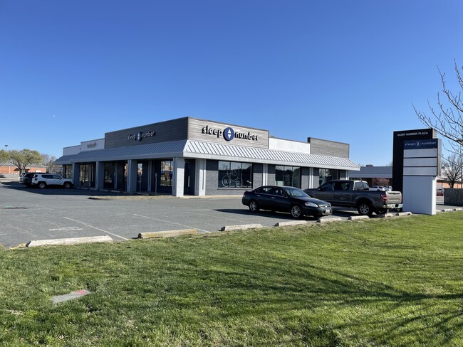
Property Record
220 Marlboro Ave, Easton, MD 21601

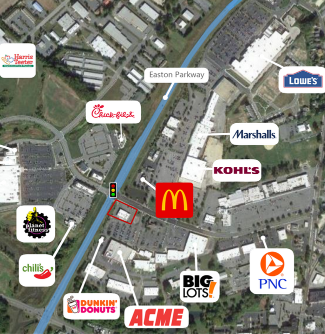
NEARBY LISTINGS FOR SALE OR LEASE
Property Detail
220 Marlboro Ave
01-055348
Marlboro Road Limited Partnership
Storebuilding
LOT .902 AC S/S MARLBORO AVE EASTON
X
Talbot
24041C0189D
Maryland
2025
0.90 AC
2025
Chesapeake Bay/Salisbury
960300
Other Market Areas
9,072 SF
Easton, MD
DEMOGRAPHICS near 220 Marlboro Ave
1 Mile
3 Mile
5 Mile
2024 Total Population
5,961
19,777
22,882
2029 Population
6,105
20,115
23,271
Pop Growth 2024-2029
+ 2.42%
+ 1.71%
+ 1.70%
Average Age
41
44
45
2024 Total Households
2,566
8,435
9,783
HH Growth 2024-2029
+ 2.34%
+ 1.70%
+ 1.68%
Median Household Inc
$54,829
$73,561
$76,660
Avg Household Size
2.20
2.30
2.30
2024 Avg HH Vehicles
1.00
2.00
2.00
Median Home Value
$277,408
$320,081
$332,919
Median Year Built
1972
1984
1984
Nearby Places
Map Layers
Map Styles
 Street
 Aerial
- Restaurants
- Banks
- Shops
- Fitness
- Groceries
SALE & LEASE HISTORY
LISTING DATE
SALE/LEASE

Sep 24, 2016
For Sale
Nov 17, 2017
For Lease
May 03, 2018
For Lease
Jun 05, 2023
For Lease
Jul 30, 2024
For Lease
Aug 06, 2019
For Lease
Nearby Properties
Address
Land Use
TOTAL SIZE
Lot Size
Zoning
Address
Land Use
TOTAL SIZE
Lot Size
Zoning
Address
Land Use
TOTAL SIZE
Lot Size
Zoning
110,432 SF
21.45 AC
Address
Land Use
TOTAL SIZE
Lot Size
Zoning
12,777 SF
33.73 AC
Address
Land Use
TOTAL SIZE
Lot Size
Zoning
15,974 SF
27.06 AC
Address
Land Use
TOTAL SIZE
Lot Size
Zoning
13.90 AC
Address
Land Use
TOTAL SIZE
Lot Size
Zoning
60,769 SF
10 AC
Address
Land Use
TOTAL SIZE
Lot Size
Zoning
100,000 SF
32.91 AC
Address
Land Use
TOTAL SIZE
Lot Size
Zoning
5,663 SF
462.53 AC
Address
Land Use
TOTAL SIZE
Lot Size
Zoning
65,836 SF
0.99 AC
Address
Land Use
TOTAL SIZE
Lot Size
Zoning
125,630 SF
8.97 AC
Address
Land Use
TOTAL SIZE
Lot Size
Zoning
62,620 SF
5.65 AC
Address
Land Use
TOTAL SIZE
Lot Size
Zoning
137,863 SF
14.58 AC
Address
Land Use
TOTAL SIZE
Lot Size
Zoning
63,190 SF
4.46 AC
Address
Land Use
TOTAL SIZE
Lot Size
Zoning
47,390 SF
13.28 AC
Address
Land Use
TOTAL SIZE
Lot Size
Zoning
64,832 SF
9.24 AC
Address
Land Use
TOTAL SIZE
Lot Size
Zoning
38,000 SF
0.87 AC
Address
Land Use
TOTAL SIZE
Lot Size
Zoning
12.61 AC
Address
Land Use
TOTAL SIZE
Lot Size
Zoning
19,950 SF
3.73 AC
Address
Land Use
TOTAL SIZE
Lot Size
Zoning
134,471 SF
12.02 AC
Address
Land Use
TOTAL SIZE
Lot Size
Zoning
75,174 SF
9.06 AC
Address
Land Use
TOTAL SIZE
Lot Size
Zoning
32,487 SF
13.99 AC
Address
Land Use
TOTAL SIZE
Lot Size
Zoning
6.97 AC
Address
Land Use
TOTAL SIZE
Lot Size
Zoning
54,079 SF
10.43 AC
Address
Land Use
TOTAL SIZE
Lot Size
Zoning
40,144 SF
1.38 AC
Address
Land Use
TOTAL SIZE
Lot Size
Zoning
34,773 SF
12 AC
Address
Land Use
TOTAL SIZE
Lot Size
Zoning
11.19 AC
Address
Land Use
TOTAL SIZE
Lot Size
Zoning
28,174 SF
1.80 AC
Address
Land Use
TOTAL SIZE
Lot Size
Zoning
59,320 SF
25 AC
Address
Land Use
TOTAL SIZE
Lot Size
Zoning
44,015 SF
7.40 AC
Address
Land Use
TOTAL SIZE
Lot Size
Zoning
1,080 SF
56 AC
The World's #1 Commercial Real Estate Marketplace
Connect with us
© 2025 CoStar Group
The information above has been obtained from sources believed reliable. While we do not doubt its accuracy we have not verified it and make no guarantee, warranty or representation about it. It is your responsibility to independently confirm its accuracy and completeness. Any projections, opinions, assumptions, or estimates used are for example only and do not represent the current or future performance of the property. The value of this transaction to you depends on tax and other factors which should be evaluated by your tax, financial, and legal advisors. You and your advisors should conduct a careful, independent investigation of the property to determine to your satisfaction the suitability of the property for your needs.