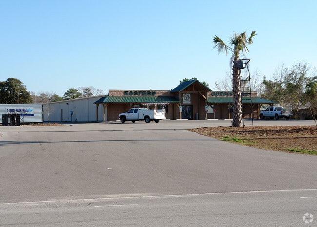
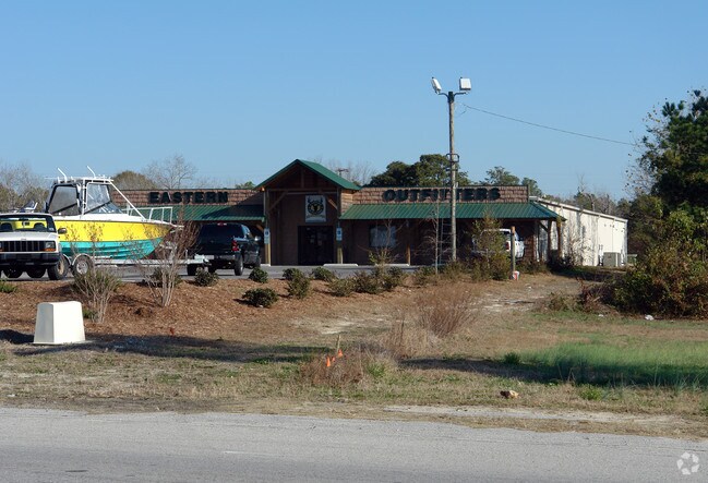
Property Record
180 Nc Highway 210 W, Hampstead, NC 28443

Property Detail
180 Nc Highway 210 W
3282-87-3771-0000
3.95 ACRES NC HWY 210 & SR 1570
Storebuilding
PENDER
B2
North Carolina
B and X Area of moderate flood hazard, usually the area between the limits of the 100-year and 500-year floods.
3.95 AC
2025
East Pender County
2025
Wilmington
920203
Wilmington, NC
12,000 SF
NEARBY LISTINGS FOR SALE OR LEASE
-
-
-
No Photo
-
View all Hampstead listings for sale on LoopNet.com
DEMOGRAPHICS near 180 Nc Highway 210 W
1 mile
3 mile
5 mile
2025 Total Population
2,615
11,477
21,565
2030 Population
2,958
12,946
24,329
Pop Growth 2025-2030
+ 13.12%
+ 12.80%
+ 12.82%
Average Age
39
40
41
2025 Total Households
1,001
4,348
8,286
HH Growth 2025-2030
+ 13.49%
+ 13.18%
+ 13.18%
Median Household Inc
$94,804
$98,946
$94,579
Avg Household Size
2.60
2.60
2.60
2025 Avg HH Vehicles
2.00
2.00
2.00
Median Home Value
$398,595
$415,769
$415,319
Median Year Built
2005
2004
2003
Nearby Places
Map Layers
Map Styles
 Street
 Aerial
Layers
 Traffic
 Biking
Places
Listings with unknown addresses are not visible on the map
- Restaurants
- Banks
- Shops
- Fitness
- Groceries
PUBLIC TRANSPORTATION
AIRPORT
Wilmington International
Drive
Walk
Distance
Wilmington International
30 min
18.8 mi
Albert J Ellis
Drive
Walk
Distance
Albert J Ellis
69 min
46.0 mi
Freight Ports
Port of Wilmington
Drive
Walk
Distance
Port of Wilmington
37 min
26.4 mi
Nearby Properties
Address
Land Use
TOTAL SIZE
Lot Size
Zoning
Address
Land Use
TOTAL SIZE
Lot Size
Zoning
187,606 SF
18 AC
SEEMAP
Address
Land Use
TOTAL SIZE
Lot Size
Zoning
80,712 SF
16.69 AC
Address
Land Use
TOTAL SIZE
Lot Size
Zoning
33,891 SF
38.51 AC
PD
Address
Land Use
TOTAL SIZE
Lot Size
Zoning
62,893 SF
24.19 AC
PD
Address
Land Use
TOTAL SIZE
Lot Size
Zoning
90,501 SF
7.03 AC
GB
Address
Land Use
TOTAL SIZE
Lot Size
Zoning
6,364 SF
11.40 AC
R20
Address
Land Use
TOTAL SIZE
Lot Size
Zoning
63,886 SF
11.51 AC
PD
Address
Land Use
TOTAL SIZE
Lot Size
Zoning
45,636 SF
6.45 AC
GB
Address
Land Use
TOTAL SIZE
Lot Size
Zoning
49,000 SF
4.29 AC
Address
Land Use
TOTAL SIZE
Lot Size
Zoning
24,000 SF
2.79 AC
B2
Address
Land Use
TOTAL SIZE
Lot Size
Zoning
16,748 SF
6.26 AC
SEEMAP
Address
Land Use
TOTAL SIZE
Lot Size
Zoning
11,828 SF
1 AC
Address
Land Use
TOTAL SIZE
Lot Size
Zoning
12,452 SF
1.16 AC
Address
Land Use
TOTAL SIZE
Lot Size
Zoning
25,000 SF
1.96 AC
SEEMAP
Address
Land Use
TOTAL SIZE
Lot Size
Zoning
21,807 SF
9.76 AC
SEEMAP
Address
Land Use
TOTAL SIZE
Lot Size
Zoning
8,120 SF
15.73 AC
SEEMAP
Address
Land Use
TOTAL SIZE
Lot Size
Zoning
11,852 SF
0.45 AC
B2
Address
Land Use
TOTAL SIZE
Lot Size
Zoning
41.76 AC
GB
Address
Land Use
TOTAL SIZE
Lot Size
Zoning
4,500 SF
2.75 AC
SEEMAP
Address
Land Use
TOTAL SIZE
Lot Size
Zoning
12,000 SF
4.30 AC
SEEMAP
Address
Land Use
TOTAL SIZE
Lot Size
Zoning
23,588 SF
5 AC
Address
Land Use
TOTAL SIZE
Lot Size
Zoning
Address
Land Use
TOTAL SIZE
Lot Size
Zoning
10,850 SF
152.72 AC
PD
Address
Land Use
TOTAL SIZE
Lot Size
Zoning
65.95 AC
SEEMAP
Address
Land Use
TOTAL SIZE
Lot Size
Zoning
9,253 SF
0.95 AC
B2
Address
Land Use
TOTAL SIZE
Lot Size
Zoning
12,000 SF
1.63 AC
GB
Address
Land Use
TOTAL SIZE
Lot Size
Zoning
3,240 SF
1.75 AC
SEEMAP
Address
Land Use
TOTAL SIZE
Lot Size
Zoning
23,565 SF
3.15 AC
B2
The World's #1 Commercial Real Estate Marketplace
Connect with us
© 2026 CoStar Group
The information above has been obtained from sources believed reliable. While we do not doubt its accuracy we have not verified it and make no guarantee, warranty or representation about it. It is your responsibility to independently confirm its accuracy and completeness. Any projections, opinions, assumptions, or estimates used are for example only and do not represent the current or future performance of the property. The value of this transaction to you depends on tax and other factors which should be evaluated by your tax, financial, and legal advisors. You and your advisors should conduct a careful, independent investigation of the property to determine to your satisfaction the suitability of the property for your needs.