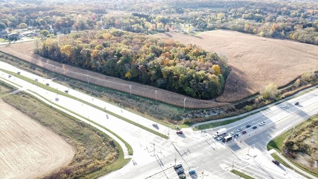
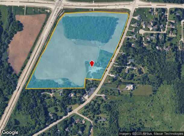
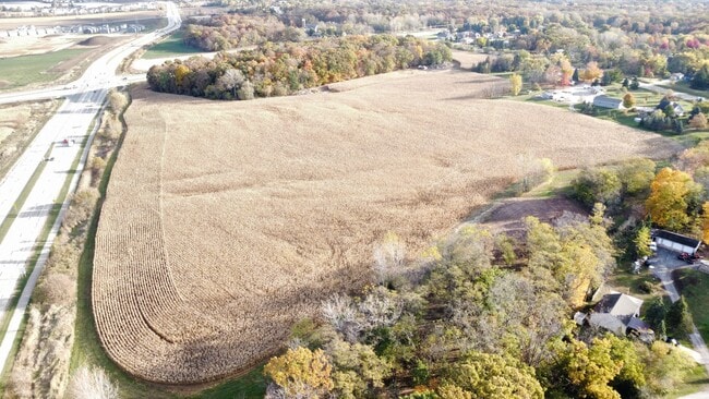
Property Record
220 Old Green Bay Rd, Kenosha, WI 53144
This Property Is For Sale
NEARBY LISTINGS FOR SALE OR LEASE
Property Detail
220 Old Green Bay Rd
Chicago-Naperville-Elgin, IL-IN-WI
Village Of Somers
82-4-222-022-0104
Kenosha
Ruralagriculturalresidence
Wisconsin
AE
43.51 AC
55059C0086D
Kenosha East
1,624 SF
Chicago
DEMOGRAPHICS near 220 Old Green Bay Rd
1 Mile
3 Mile
5 Mile
2024 Total Population
1,189
26,620
97,623
2029 Population
1,224
26,792
98,071
Pop Growth 2024-2029
+ 2.94%
+ 0.65%
+ 0.46%
Average Age
40
42
41
2024 Total Households
358
10,936
39,539
HH Growth 2024-2029
+ 3.35%
+ 0.49%
+ 0.48%
Median Household Inc
$125,758
$79,036
$68,630
Avg Household Size
2.40
2.30
2.30
2024 Avg HH Vehicles
2.00
2.00
2.00
Median Home Value
$406,977
$291,838
$212,743
Median Year Built
1994
1979
1970
Nearby Places
- Restaurants
- Banks
- Shops
- Fitness
- Groceries
PUBLIC TRANSPORTATION
COMMUTER RAIL
Sturtevant Amtrak Station (Hiawatha Service - Amtrak)
DRIVE
WALK
Distance
Sturtevant Amtrak Station (Hiawatha Service - Amtrak)
13 min
6.6 mi
Kenosha Station (Union Pacific North Line - Northeast Illinois Regional Commuter Railroad (Metra))
DRIVE
WALK
Distance
Kenosha Station (Union Pacific North Line - Northeast Illinois Regional Commuter Railroad (Metra))
16 min
8.5 mi
AIRPORT
General Mitchell International
DRIVE
WALK
Distance
General Mitchell International
34 min
25.8 mi
Freight Ports
Port Milwaukee
DRIVE
WALK
Distance
Port Milwaukee
39 min
29.7 mi
Nearby Properties
Address
Land Use
TOTAL SIZE
Lot Size
Zoning
Address
Land Use
TOTAL SIZE
Lot Size
Zoning
861.42 AC
Address
Land Use
TOTAL SIZE
Lot Size
Zoning
318.64 AC
Address
Land Use
TOTAL SIZE
Lot Size
Zoning
22.34 AC
Address
Land Use
TOTAL SIZE
Lot Size
Zoning
241.29 AC
Address
Land Use
TOTAL SIZE
Lot Size
Zoning
773 SF
21.36 AC
Address
Land Use
TOTAL SIZE
Lot Size
Zoning
47.01 AC
M-1
Address
Land Use
TOTAL SIZE
Lot Size
Zoning
9.31 AC
Address
Land Use
TOTAL SIZE
Lot Size
Zoning
22.98 AC
M-1
Address
Land Use
TOTAL SIZE
Lot Size
Zoning
16,466 SF
19.09 AC
RM2
Address
Land Use
TOTAL SIZE
Lot Size
Zoning
21,072 SF
24.33 AC
RM2
Address
Land Use
TOTAL SIZE
Lot Size
Zoning
19.77 AC
B-3
Address
Land Use
TOTAL SIZE
Lot Size
Zoning
6.77 AC
PUL
Address
Land Use
TOTAL SIZE
Lot Size
Zoning
26,500 SF
17.79 AC
RM2
Address
Land Use
TOTAL SIZE
Lot Size
Zoning
15.81 AC
Address
Land Use
TOTAL SIZE
Lot Size
Zoning
0.11 AC
B-3
Address
Land Use
TOTAL SIZE
Lot Size
Zoning
15,084 SF
34.20 AC
Address
Land Use
TOTAL SIZE
Lot Size
Zoning
164,201 SF
17 AC
B2
Address
Land Use
TOTAL SIZE
Lot Size
Zoning
Address
Land Use
TOTAL SIZE
Lot Size
Zoning
26.05 AC
Address
Land Use
TOTAL SIZE
Lot Size
Zoning
76.18 AC
Address
Land Use
TOTAL SIZE
Lot Size
Zoning
11.70 AC
M-1
Address
Land Use
TOTAL SIZE
Lot Size
Zoning
11.56 AC
Address
Land Use
TOTAL SIZE
Lot Size
Zoning
102,312 SF
9.92 AC
B2
Address
Land Use
TOTAL SIZE
Lot Size
Zoning
105,550 SF
13.43 AC
Address
Land Use
TOTAL SIZE
Lot Size
Zoning
9,860 SF
14.55 AC
RM2
Address
Land Use
TOTAL SIZE
Lot Size
Zoning
Address
Land Use
TOTAL SIZE
Lot Size
Zoning
Address
Land Use
TOTAL SIZE
Lot Size
Zoning
3,348 SF
3.21 AC
Address
Land Use
TOTAL SIZE
Lot Size
Zoning
13,224 SF
8.88 AC
Address
Land Use
TOTAL SIZE
Lot Size
Zoning
4.46 AC
005
The World's #1 Commercial Real Estate Marketplace
Connect with us
© 2025 CoStar Group
The information above has been obtained from sources believed reliable. While we do not doubt its accuracy we have not verified it and make no guarantee, warranty or representation about it. It is your responsibility to independently confirm its accuracy and completeness. Any projections, opinions, assumptions, or estimates used are for example only and do not represent the current or future performance of the property. The value of this transaction to you depends on tax and other factors which should be evaluated by your tax, financial, and legal advisors. You and your advisors should conduct a careful, independent investigation of the property to determine to your satisfaction the suitability of the property for your needs.