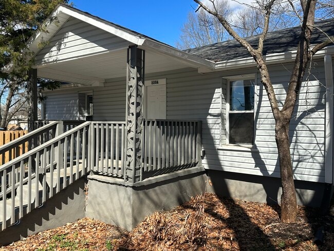
Property Record
220 Pointer Rd, Forest City, NC 28043


NEARBY LISTINGS FOR SALE OR LEASE
-
-
View all Forest City listings for sale on LoopNet.com
Property Detail
220 Pointer Rd
Forest City, NC
F B Harrill Farm At Alexander Mills
425052
LO:62TO64 PL:1-1
Realpropertynec
Rutherford
X
North Carolina
3710154700J
62to64
2025
North Carolina West/Cherokee Area
2025
Other Market Areas
960900
DEMOGRAPHICS near 220 Pointer Rd
1 mile
3 mile
5 mile
2024 Total Population
1,435
11,925
25,208
2029 Population
1,449
12,061
25,447
Pop Growth 2024-2029
+ 0.98%
+ 1.14%
+ 0.95%
Average Age
39
41
41
2024 Total Households
585
4,908
10,205
HH Growth 2024-2029
+ 0.85%
+ 1.00%
+ 0.83%
Median Household Inc
$43,749
$36,299
$40,707
Avg Household Size
2.30
2.30
2.40
2024 Avg HH Vehicles
2.00
2.00
2.00
Median Home Value
$150,450
$132,272
$138,745
Median Year Built
1971
1971
1973
Nearby Places
Map Layers
Map Styles
 Street
 Aerial
Transit
 Traffic
 Biking
Places
Listings with unknown addresses are not visible on the map
- Restaurants
- Banks
- Shops
- Fitness
- Groceries
PUBLIC TRANSPORTATION
AIRPORT
Greenville Spartanburg International
Drive
Walk
Distance
Greenville Spartanburg International
67 min
45.9 mi
SALE & LEASE HISTORY
LISTING DATE
SALE/LEASE

May 08, 2024
For Sale
Nearby Properties
Address
Land Use
TOTAL SIZE
Lot Size
Zoning
Address
Land Use
TOTAL SIZE
Lot Size
Zoning
26,465 SF
61.74 AC
M1
Address
Land Use
TOTAL SIZE
Lot Size
Zoning
24,095 SF
72.22 AC
M1
Address
Land Use
TOTAL SIZE
Lot Size
Zoning
204,184 SF
28.30 AC
C3
Address
Land Use
TOTAL SIZE
Lot Size
Zoning
124,707 SF
30.99 AC
C3
Address
Land Use
TOTAL SIZE
Lot Size
Zoning
15,128 SF
81 AC
Address
Land Use
TOTAL SIZE
Lot Size
Zoning
37,979 SF
9.36 AC
R8
Address
Land Use
TOTAL SIZE
Lot Size
Zoning
64,697 SF
18.07 AC
R8
Address
Land Use
TOTAL SIZE
Lot Size
Zoning
23,826 SF
13.78 AC
M1
Address
Land Use
TOTAL SIZE
Lot Size
Zoning
111,158 SF
11.15 AC
C3
Address
Land Use
TOTAL SIZE
Lot Size
Zoning
343,372 SF
49.89 AC
M1ETJ
Address
Land Use
TOTAL SIZE
Lot Size
Zoning
14,832 SF
3.11 AC
C2
Address
Land Use
TOTAL SIZE
Lot Size
Zoning
87,740 SF
10.47 AC
C3
Address
Land Use
TOTAL SIZE
Lot Size
Zoning
3,665 SF
9.07 AC
C3
Address
Land Use
TOTAL SIZE
Lot Size
Zoning
12,580 SF
7.90 AC
R8
Address
Land Use
TOTAL SIZE
Lot Size
Zoning
483 SF
6.26 AC
C3
Address
Land Use
TOTAL SIZE
Lot Size
Zoning
36,693 SF
3.04 AC
C3
Address
Land Use
TOTAL SIZE
Lot Size
Zoning
4,700 SF
4.70 AC
C2
Address
Land Use
TOTAL SIZE
Lot Size
Zoning
1,444 SF
5.06 AC
C3
Address
Land Use
TOTAL SIZE
Lot Size
Zoning
6,320 SF
10.50 AC
R6
Address
Land Use
TOTAL SIZE
Lot Size
Zoning
17,755 SF
7.05 AC
R8
Address
Land Use
TOTAL SIZE
Lot Size
Zoning
9,900 SF
16.51 AC
Address
Land Use
TOTAL SIZE
Lot Size
Zoning
1.25 AC
R8
Address
Land Use
TOTAL SIZE
Lot Size
Zoning
34,756 SF
2.38 AC
C2
Address
Land Use
TOTAL SIZE
Lot Size
Zoning
12,208 SF
2.68 AC
C3
Address
Land Use
TOTAL SIZE
Lot Size
Zoning
5,504 SF
4.14 AC
R8
Address
Land Use
TOTAL SIZE
Lot Size
Zoning
1,728 SF
10.29 AC
M1
Address
Land Use
TOTAL SIZE
Lot Size
Zoning
3,430 SF
12.49 AC
R20ETJ
Address
Land Use
TOTAL SIZE
Lot Size
Zoning
24,900 SF
1.68 AC
C3
Address
Land Use
TOTAL SIZE
Lot Size
Zoning
6,000 SF
24.43 AC
R6
Address
Land Use
TOTAL SIZE
Lot Size
Zoning
2,490 SF
24.55 AC
R8
The World's #1 Commercial Real Estate Marketplace
Connect with us
© 2026 CoStar Group
The information above has been obtained from sources believed reliable. While we do not doubt its accuracy we have not verified it and make no guarantee, warranty or representation about it. It is your responsibility to independently confirm its accuracy and completeness. Any projections, opinions, assumptions, or estimates used are for example only and do not represent the current or future performance of the property. The value of this transaction to you depends on tax and other factors which should be evaluated by your tax, financial, and legal advisors. You and your advisors should conduct a careful, independent investigation of the property to determine to your satisfaction the suitability of the property for your needs.