Property Record
220 Pointer Rd, Forest City, NC 28043
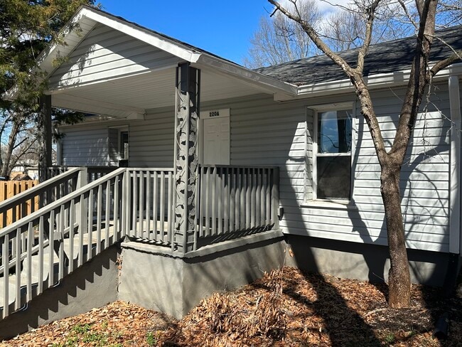


Property Detail
220 Pointer Rd
425052
LO:62TO64 PL:1-1
Realpropertynec
Rutherford
R6
North Carolina
B and X Area of moderate flood hazard, usually the area between the limits of the 100-year and 500-year floods.
62to64
2025
North Carolina West/Cherokee Area
2025
Other Market Areas
960900
Forest City, NC
156 SF
NEARBY LISTINGS FOR SALE OR LEASE
-
-
View all Forest City listings for sale on LoopNet.com
DEMOGRAPHICS near 220 Pointer Rd
1 mile
3 mile
5 mile
2025 Total Population
1,442
11,889
25,118
2030 Population
1,454
11,972
25,252
Pop Growth 2025-2030
+ 0.83%
+ 0.70%
+ 0.53%
Average Age
40
41
42
2025 Total Households
587
4,897
10,182
HH Growth 2025-2030
+ 0.51%
+ 0.57%
+ 0.43%
Median Household Inc
$41,447
$39,831
$41,039
Avg Household Size
2.30
2.30
2.40
2025 Avg HH Vehicles
2.00
2.00
2.00
Median Home Value
$255,084
$178,350
$189,132
Median Year Built
1972
1971
1973
Nearby Places
Map Layers
Map Styles
 Street
 Aerial
Layers
 Traffic
 Biking
Places
Listings with unknown addresses are not visible on the map
- Restaurants
- Banks
- Shops
- Fitness
- Groceries
SALE & LEASE HISTORY
LISTING DATE
SALE/LEASE

May 08, 2024
For Sale
Nearby Properties
Address
Land Use
TOTAL SIZE
Lot Size
Zoning
Address
Land Use
TOTAL SIZE
Lot Size
Zoning
26,465 SF
61.74 AC
M1
Address
Land Use
TOTAL SIZE
Lot Size
Zoning
24,095 SF
72.22 AC
M1
Address
Land Use
TOTAL SIZE
Lot Size
Zoning
204,184 SF
28.30 AC
C3
Address
Land Use
TOTAL SIZE
Lot Size
Zoning
124,707 SF
30.99 AC
C3
Address
Land Use
TOTAL SIZE
Lot Size
Zoning
15,128 SF
81 AC
Address
Land Use
TOTAL SIZE
Lot Size
Zoning
37,979 SF
9.36 AC
R8
Address
Land Use
TOTAL SIZE
Lot Size
Zoning
64,697 SF
18.07 AC
R8
Address
Land Use
TOTAL SIZE
Lot Size
Zoning
23,826 SF
13.78 AC
M1
Address
Land Use
TOTAL SIZE
Lot Size
Zoning
111,158 SF
11.15 AC
C3
Address
Land Use
TOTAL SIZE
Lot Size
Zoning
343,372 SF
49.89 AC
M1ETJ
Address
Land Use
TOTAL SIZE
Lot Size
Zoning
14,832 SF
3.11 AC
C2
Address
Land Use
TOTAL SIZE
Lot Size
Zoning
87,740 SF
10.47 AC
C3
Address
Land Use
TOTAL SIZE
Lot Size
Zoning
12,580 SF
7.90 AC
R8
Address
Land Use
TOTAL SIZE
Lot Size
Zoning
483 SF
6.26 AC
C3
Address
Land Use
TOTAL SIZE
Lot Size
Zoning
36,693 SF
3.04 AC
C3
Address
Land Use
TOTAL SIZE
Lot Size
Zoning
4,700 SF
4.70 AC
C2
Address
Land Use
TOTAL SIZE
Lot Size
Zoning
1,444 SF
5.06 AC
C3
Address
Land Use
TOTAL SIZE
Lot Size
Zoning
6,320 SF
10.50 AC
R6
Address
Land Use
TOTAL SIZE
Lot Size
Zoning
17,755 SF
7.05 AC
R8
Address
Land Use
TOTAL SIZE
Lot Size
Zoning
9,900 SF
16.51 AC
Address
Land Use
TOTAL SIZE
Lot Size
Zoning
1.25 AC
R8
Address
Land Use
TOTAL SIZE
Lot Size
Zoning
34,756 SF
2.38 AC
C2
Address
Land Use
TOTAL SIZE
Lot Size
Zoning
12,208 SF
2.68 AC
C3
Address
Land Use
TOTAL SIZE
Lot Size
Zoning
1,728 SF
10.29 AC
M1
Address
Land Use
TOTAL SIZE
Lot Size
Zoning
3,430 SF
12.49 AC
R20ETJ
Address
Land Use
TOTAL SIZE
Lot Size
Zoning
24,900 SF
1.68 AC
C3
Address
Land Use
TOTAL SIZE
Lot Size
Zoning
6,000 SF
24.43 AC
R6
Address
Land Use
TOTAL SIZE
Lot Size
Zoning
2,490 SF
24.55 AC
R8
Address
Land Use
TOTAL SIZE
Lot Size
Zoning
22,145 SF
6.56 AC
C3
Address
Land Use
TOTAL SIZE
Lot Size
Zoning
8,164 SF
8.36 AC
The World's #1 Commercial Real Estate Marketplace
Connect with us
© 2026 CoStar Group
The information above has been obtained from sources believed reliable. While we do not doubt its accuracy we have not verified it and make no guarantee, warranty or representation about it. It is your responsibility to independently confirm its accuracy and completeness. Any projections, opinions, assumptions, or estimates used are for example only and do not represent the current or future performance of the property. The value of this transaction to you depends on tax and other factors which should be evaluated by your tax, financial, and legal advisors. You and your advisors should conduct a careful, independent investigation of the property to determine to your satisfaction the suitability of the property for your needs.