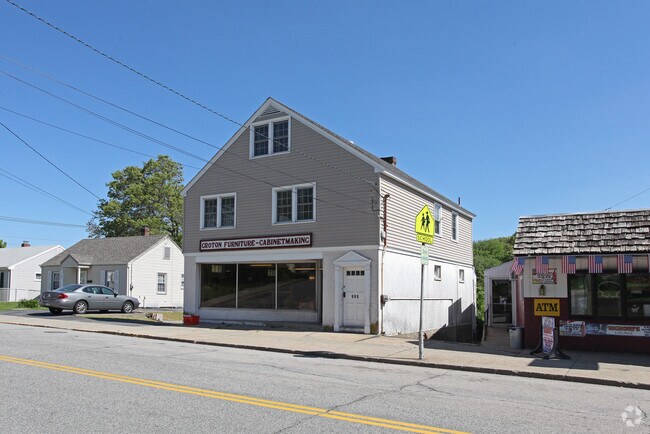
Property Record
220 Poquonnock Rd, Groton, CT 06340
NEARBY LISTINGS FOR SALE OR LEASE
Property Detail
220 Poquonnock Rd
Commercialofficeresidentialmixeduse
New London
X
Connecticut
09011C0502J
0.12 AC
2025
New London
2025
Hartford
702400
Norwich-New London, CT
6,164 SF
GROT-001688-000767-004610
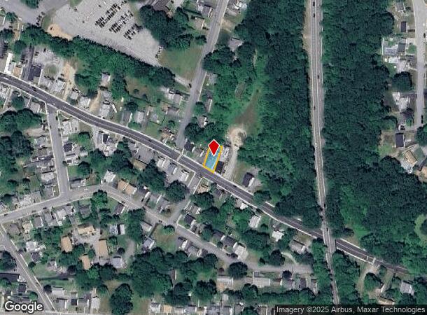
DEMOGRAPHICS near 220 Poquonnock Rd
1 Mile
3 Mile
5 Mile
2024 Total Population
8,001
52,756
78,773
2029 Population
7,935
52,716
78,863
Pop Growth 2024-2029
(0.82%)
(0.08%)
+ 0.11%
Average Age
38
38
40
2024 Total Households
3,827
21,724
32,608
HH Growth 2024-2029
(0.78%)
(0.03%)
+ 0.17%
Median Household Inc
$57,930
$60,108
$71,097
Avg Household Size
2.00
2.20
2.20
2024 Avg HH Vehicles
1.00
1.00
2.00
Median Home Value
$206,780
$219,298
$269,720
Median Year Built
1971
1965
1967
Nearby Places
Map Layers
Map Styles
 Street
 Aerial
- Restaurants
- Banks
- Shops
- Fitness
- Groceries
PUBLIC TRANSPORTATION
COMMUTER RAIL
New London (Shore Line East - Shore Line East)
DRIVE
WALK
Distance
New London (Shore Line East - Shore Line East)
9 min
4.5 mi
DRIVE
WALK
Distance
12 min
6.5 mi
Freight Ports
Port of New Haven
DRIVE
WALK
Distance
Port of New Haven
63 min
48.2 mi
SALE & LEASE HISTORY
LISTING DATE
SALE/LEASE

Nov 09, 2018
For Sale
Nearby Properties
Address
Land Use
TOTAL SIZE
Lot Size
Zoning
Address
Land Use
TOTAL SIZE
Lot Size
Zoning
10,521 SF
441.93 AC
IG
Address
Land Use
TOTAL SIZE
Lot Size
Zoning
3,135 SF
46.10 AC
ROS
Address
Land Use
TOTAL SIZE
Lot Size
Zoning
24.41 AC
WCI-2
Address
Land Use
TOTAL SIZE
Lot Size
Zoning
8,712 SF
RU-20
Address
Land Use
TOTAL SIZE
Lot Size
Zoning
45,582 SF
39.40 AC
WCI-1
Address
Land Use
TOTAL SIZE
Lot Size
Zoning
49.32 AC
R-3
Address
Land Use
TOTAL SIZE
Lot Size
Zoning
42,688 SF
19.22 AC
RM
Address
Land Use
TOTAL SIZE
Lot Size
Zoning
50 AC
OS
Address
Land Use
TOTAL SIZE
Lot Size
Zoning
404.81 AC
GC
Address
Land Use
TOTAL SIZE
Lot Size
Zoning
276.72 AC
GC
Address
Land Use
TOTAL SIZE
Lot Size
Zoning
8,820 SF
66.22 AC
R-12
Address
Land Use
TOTAL SIZE
Lot Size
Zoning
28,764 SF
37.76 AC
RM
Address
Land Use
TOTAL SIZE
Lot Size
Zoning
287.66 AC
RU-20
Address
Land Use
TOTAL SIZE
Lot Size
Zoning
59,264 SF
54.53 AC
I/T
Address
Land Use
TOTAL SIZE
Lot Size
Zoning
11,880 SF
35.66 AC
RM
Address
Land Use
TOTAL SIZE
Lot Size
Zoning
13.68 AC
CR
Address
Land Use
TOTAL SIZE
Lot Size
Zoning
60.63 AC
RU-20
Address
Land Use
TOTAL SIZE
Lot Size
Zoning
73,446 SF
69.87 AC
R-12
Address
Land Use
TOTAL SIZE
Lot Size
Zoning
104,052 SF
27.36 AC
RM
Address
Land Use
TOTAL SIZE
Lot Size
Zoning
178,385 SF
5.42 AC
LI-O
Address
Land Use
TOTAL SIZE
Lot Size
Zoning
12.03 AC
INST
Address
Land Use
TOTAL SIZE
Lot Size
Zoning
26.44 AC
C-G
Address
Land Use
TOTAL SIZE
Lot Size
Zoning
55,766 SF
1.33 AC
R-4
Address
Land Use
TOTAL SIZE
Lot Size
Zoning
66.87 AC
RU-20
Address
Land Use
TOTAL SIZE
Lot Size
Zoning
231,514 SF
9.33 AC
IM
Address
Land Use
TOTAL SIZE
Lot Size
Zoning
125,275 SF
10 AC
RM
Address
Land Use
TOTAL SIZE
Lot Size
Zoning
79,535 SF
3.03 AC
R-2
Address
Land Use
TOTAL SIZE
Lot Size
Zoning
204,329 SF
17.92 AC
CR
Address
Land Use
TOTAL SIZE
Lot Size
Zoning
135,113 SF
2.51 AC
LI-O
Address
Land Use
TOTAL SIZE
Lot Size
Zoning
9.41 AC
R-4
The World's #1 Commercial Real Estate Marketplace
Connect with us
© 2025 CoStar Group
The information above has been obtained from sources believed reliable. While we do not doubt its accuracy we have not verified it and make no guarantee, warranty or representation about it. It is your responsibility to independently confirm its accuracy and completeness. Any projections, opinions, assumptions, or estimates used are for example only and do not represent the current or future performance of the property. The value of this transaction to you depends on tax and other factors which should be evaluated by your tax, financial, and legal advisors. You and your advisors should conduct a careful, independent investigation of the property to determine to your satisfaction the suitability of the property for your needs.