Property Record
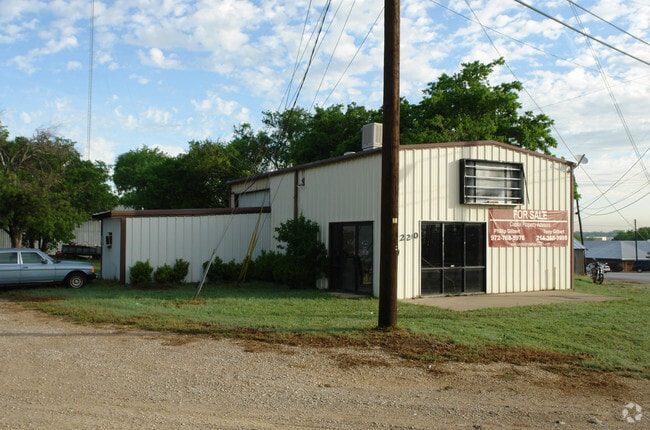
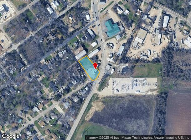
220 S Highway 77, Waxahachie, TX 75165

NEARBY LISTINGS FOR SALE OR LEASE
Property Detail
220 S Highway 77
Dallas-Fort Worth-Arlington, TX
Bullard-Rev
172487
LOT 9-10 BLK 58 BULLARD-REV .541 AC
Commercialnec
Ellis
X
Texas
48139C0190G
9-10
0
0.54 AC
2025
Southwest Outlying
060500
Dallas/Ft Worth
1,256 SF
DEMOGRAPHICS near 220 S Highway 77
1 Mile
3 Mile
5 Mile
2024 Total Population
4,883
30,419
55,021
2029 Population
6,147
38,441
69,935
Pop Growth 2024-2029
+ 25.89%
+ 26.37%
+ 27.11%
Average Age
39
37
37
2024 Total Households
1,767
10,899
19,173
HH Growth 2024-2029
+ 26.37%
+ 26.60%
+ 27.29%
Median Household Inc
$47,790
$63,638
$78,799
Avg Household Size
2.50
2.60
2.70
2024 Avg HH Vehicles
2.00
2.00
2.00
Median Home Value
$195,698
$231,982
$261,116
Median Year Built
1987
1988
2000
Nearby Places
Map Layers
Map Styles
 Street
 Aerial
- Restaurants
- Banks
- Shops
- Fitness
- Groceries
PUBLIC TRANSPORTATION
AIRPORT
Dallas Love Field
DRIVE
WALK
Distance
Dallas Love Field
46 min
36.0 mi
SALE & LEASE HISTORY
LISTING DATE
SALE/LEASE

Jun 04, 2019
For Sale
Nearby Properties
Address
Land Use
TOTAL SIZE
Lot Size
Zoning
Address
Land Use
TOTAL SIZE
Lot Size
Zoning
630,460 SF
71.82 AC
Address
Land Use
TOTAL SIZE
Lot Size
Zoning
290,107 SF
9 AC
Address
Land Use
TOTAL SIZE
Lot Size
Zoning
259,166 SF
11.07 AC
Address
Land Use
TOTAL SIZE
Lot Size
Zoning
258,147 SF
12.40 AC
Address
Land Use
TOTAL SIZE
Lot Size
Zoning
134,530 SF
12.11 AC
Address
Land Use
TOTAL SIZE
Lot Size
Zoning
107,800 SF
18.46 AC
Address
Land Use
TOTAL SIZE
Lot Size
Zoning
150,886 SF
11.02 AC
Address
Land Use
TOTAL SIZE
Lot Size
Zoning
63,720 SF
17.38 AC
Address
Land Use
TOTAL SIZE
Lot Size
Zoning
114,400 SF
3.52 AC
Address
Land Use
TOTAL SIZE
Lot Size
Zoning
118,782 SF
5.11 AC
Address
Land Use
TOTAL SIZE
Lot Size
Zoning
79,800 SF
0.92 AC
Address
Land Use
TOTAL SIZE
Lot Size
Zoning
886,858 SF
8.60 AC
Address
Land Use
TOTAL SIZE
Lot Size
Zoning
68,564 SF
11.14 AC
Address
Land Use
TOTAL SIZE
Lot Size
Zoning
109,978 SF
28.14 AC
Address
Land Use
TOTAL SIZE
Lot Size
Zoning
278,000 SF
22.82 AC
Address
Land Use
TOTAL SIZE
Lot Size
Zoning
193,837 SF
10.41 AC
Address
Land Use
TOTAL SIZE
Lot Size
Zoning
115,544 SF
6.70 AC
Address
Land Use
TOTAL SIZE
Lot Size
Zoning
120,587 SF
23.95 AC
Address
Land Use
TOTAL SIZE
Lot Size
Zoning
84,940 SF
5.27 AC
Address
Land Use
TOTAL SIZE
Lot Size
Zoning
88,490 SF
19.18 AC
Address
Land Use
TOTAL SIZE
Lot Size
Zoning
103,490 SF
10 AC
Address
Land Use
TOTAL SIZE
Lot Size
Zoning
205,027 SF
22.65 AC
Address
Land Use
TOTAL SIZE
Lot Size
Zoning
211,030 SF
10.35 AC
Address
Land Use
TOTAL SIZE
Lot Size
Zoning
97,437 SF
10.85 AC
Address
Land Use
TOTAL SIZE
Lot Size
Zoning
57,343 SF
14.67 AC
Address
Land Use
TOTAL SIZE
Lot Size
Zoning
181,129 SF
15.68 AC
Address
Land Use
TOTAL SIZE
Lot Size
Zoning
43,330 SF
5 AC
Address
Land Use
TOTAL SIZE
Lot Size
Zoning
86,543 SF
147.93 AC
Address
Land Use
TOTAL SIZE
Lot Size
Zoning
4,784 SF
47.29 AC
Address
Land Use
TOTAL SIZE
Lot Size
Zoning
86,360 SF
4.26 AC
The World's #1 Commercial Real Estate Marketplace
Connect with us
© 2025 CoStar Group
The information above has been obtained from sources believed reliable. While we do not doubt its accuracy we have not verified it and make no guarantee, warranty or representation about it. It is your responsibility to independently confirm its accuracy and completeness. Any projections, opinions, assumptions, or estimates used are for example only and do not represent the current or future performance of the property. The value of this transaction to you depends on tax and other factors which should be evaluated by your tax, financial, and legal advisors. You and your advisors should conduct a careful, independent investigation of the property to determine to your satisfaction the suitability of the property for your needs.