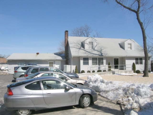
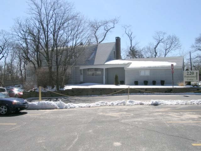
Property Record
220 S Service Rd, Roslyn Heights, NY 11577
NEARBY LISTINGS FOR SALE OR LEASE
Property Detail
220 S Service Rd
2289-07-M-00-1024-0
TOWN #2 SCH DIST 009
Financialbuilding
Nassau
X
New York
36059C0117G
765
2025
0.19 AC
2025
Western Nassau
302200
Long Island (New York)
8,000 SF
Nassau County-Suffolk County, NY
DEMOGRAPHICS near 220 S Service Rd
1 Mile
3 Mile
5 Mile
2024 Total Population
14,673
104,157
346,212
2029 Population
14,516
102,847
339,053
Pop Growth 2024-2029
(1.07%)
(1.26%)
(2.07%)
Average Age
43
43
43
2024 Total Households
4,954
35,256
117,974
HH Growth 2024-2029
(1.13%)
(1.35%)
(2.20%)
Median Household Inc
$149,281
$154,578
$131,582
Avg Household Size
2.90
2.90
2.80
2024 Avg HH Vehicles
2.00
2.00
2.00
Median Home Value
$828,825
$866,425
$801,030
Median Year Built
1956
1954
1954
Nearby Places
- Restaurants
- Banks
- Shops
- Fitness
- Groceries
PUBLIC TRANSPORTATION
COMMUTER RAIL
Roslyn Station (Oyster Bay Branch - Long Island Rail Road)
DRIVE
WALK
Distance
Roslyn Station (Oyster Bay Branch - Long Island Rail Road)
3 min
15 min
0.8 mi
Albertson Station (Oyster Bay Branch - Long Island Rail Road)
DRIVE
WALK
Distance
Albertson Station (Oyster Bay Branch - Long Island Rail Road)
3 min
1.8 mi
AIRPORT
LaGuardia
DRIVE
WALK
Distance
LaGuardia
23 min
14.7 mi
John F Kennedy International
DRIVE
WALK
Distance
John F Kennedy International
25 min
17.4 mi
Westchester County
DRIVE
WALK
Distance
Westchester County
53 min
35.1 mi
Freight Ports
NY - Red Hook Container Terminal
DRIVE
WALK
Distance
NY - Red Hook Container Terminal
35 min
22.8 mi
SALE & LEASE HISTORY
LISTING DATE
SALE/LEASE

Nov 20, 2018
For Lease
Apr 04, 2018
For Lease
Nearby Properties
Address
Land Use
TOTAL SIZE
Lot Size
Zoning
Address
Land Use
TOTAL SIZE
Lot Size
Zoning
275,334 SF
9.04 AC
Address
Land Use
TOTAL SIZE
Lot Size
Zoning
680,630 SF
72.68 AC
Address
Land Use
TOTAL SIZE
Lot Size
Zoning
375,331 SF
14.83 AC
Address
Land Use
TOTAL SIZE
Lot Size
Zoning
152,926 SF
30 AC
Address
Land Use
TOTAL SIZE
Lot Size
Zoning
63,600 SF
2 AC
Address
Land Use
TOTAL SIZE
Lot Size
Zoning
182,129 SF
1.51 AC
Address
Land Use
TOTAL SIZE
Lot Size
Zoning
152,783 SF
51.20 AC
Address
Land Use
TOTAL SIZE
Lot Size
Zoning
158,725 SF
24.46 AC
Address
Land Use
TOTAL SIZE
Lot Size
Zoning
148,942 SF
34.17 AC
Address
Land Use
TOTAL SIZE
Lot Size
Zoning
401,583 SF
17.93 AC
Address
Land Use
TOTAL SIZE
Lot Size
Zoning
50,252 SF
143.04 AC
Address
Land Use
TOTAL SIZE
Lot Size
Zoning
147,148 SF
8.39 AC
Address
Land Use
TOTAL SIZE
Lot Size
Zoning
49,950 SF
51.02 AC
Address
Land Use
TOTAL SIZE
Lot Size
Zoning
80,819 SF
6.90 AC
Address
Land Use
TOTAL SIZE
Lot Size
Zoning
31,828 SF
14.74 AC
Address
Land Use
TOTAL SIZE
Lot Size
Zoning
171,770 SF
5.95 AC
Address
Land Use
TOTAL SIZE
Lot Size
Zoning
84,966 SF
18.74 AC
Address
Land Use
TOTAL SIZE
Lot Size
Zoning
179,365 SF
6.05 AC
Address
Land Use
TOTAL SIZE
Lot Size
Zoning
45,898 SF
85.13 AC
Address
Land Use
TOTAL SIZE
Lot Size
Zoning
165,793 SF
18.61 AC
Address
Land Use
TOTAL SIZE
Lot Size
Zoning
23,871 SF
11.07 AC
Address
Land Use
TOTAL SIZE
Lot Size
Zoning
56,663 SF
388.75 AC
Address
Land Use
TOTAL SIZE
Lot Size
Zoning
552,672 SF
8.72 AC
Address
Land Use
TOTAL SIZE
Lot Size
Zoning
109,503 SF
12.88 AC
Address
Land Use
TOTAL SIZE
Lot Size
Zoning
140,916 SF
3.14 AC
Address
Land Use
TOTAL SIZE
Lot Size
Zoning
Address
Land Use
TOTAL SIZE
Lot Size
Zoning
114,441 SF
34.81 AC
Address
Land Use
TOTAL SIZE
Lot Size
Zoning
47,328 SF
11.84 AC
Address
Land Use
TOTAL SIZE
Lot Size
Zoning
64,700 SF
2.51 AC
Address
Land Use
TOTAL SIZE
Lot Size
Zoning
530,907 SF
21.69 AC
The World's #1 Commercial Real Estate Marketplace
Connect with us
© 2025 CoStar Group
The information above has been obtained from sources believed reliable. While we do not doubt its accuracy we have not verified it and make no guarantee, warranty or representation about it. It is your responsibility to independently confirm its accuracy and completeness. Any projections, opinions, assumptions, or estimates used are for example only and do not represent the current or future performance of the property. The value of this transaction to you depends on tax and other factors which should be evaluated by your tax, financial, and legal advisors. You and your advisors should conduct a careful, independent investigation of the property to determine to your satisfaction the suitability of the property for your needs.