Property Record
220 Seymour St, Williamstown, NJ 08094
NEARBY LISTINGS FOR SALE OR LEASE
-
-
View all Williamstown listings for sale on LoopNet.com
Property Detail
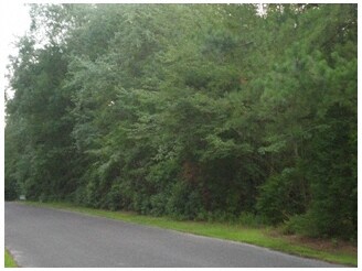
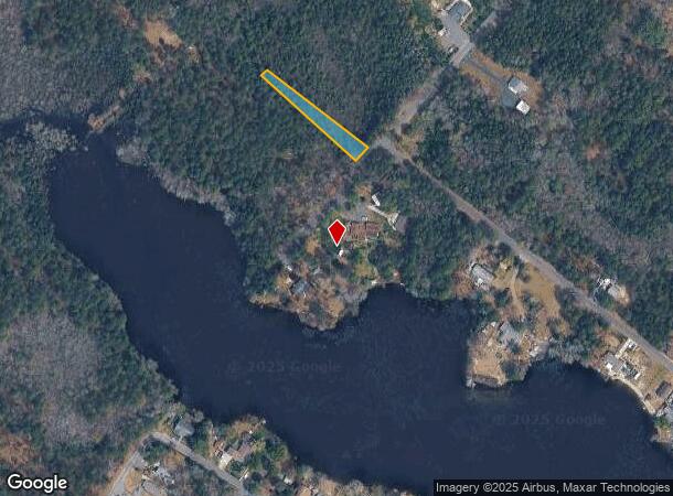
220 Seymour St
Philadelphia-Camden-Wilmington, PA-NJ-DE-MD
Diamond Lake Grove Sec 01
11-07502-0000-00019
ALSO BLK 7414 LOT 6 LAND CODE 3 8
Vacantlandnec
Gloucester
AE
New Jersey
34015C0306E
19
2024
2.01 AC
2025
Gloucester County
501605
Philadelphia
DEMOGRAPHICS near 220 Seymour St
1 Mile
3 Mile
5 Mile
2024 Total Population
359
6,028
18,879
2029 Population
373
6,183
19,314
Pop Growth 2024-2029
+ 3.90%
+ 2.57%
+ 2.30%
Average Age
50
44
42
2024 Total Households
171
2,429
6,955
HH Growth 2024-2029
+ 3.51%
+ 2.55%
+ 2.24%
Median Household Inc
$56,818
$69,429
$92,274
Avg Household Size
2.10
2.40
2.70
2024 Avg HH Vehicles
2.00
2.00
2.00
Median Home Value
$107,143
$168,497
$233,278
Median Year Built
1977
1972
1975
Nearby Places
Map Layers
Map Styles
 Street
 Aerial
- Restaurants
- Banks
- Shops
- Fitness
- Groceries
PUBLIC TRANSPORTATION
COMMUTER RAIL
Hammonton (Atlantic City Line - NJ Transit Commuter Rail (NJ Transit))
DRIVE
WALK
Distance
Hammonton (Atlantic City Line - NJ Transit Commuter Rail (NJ Transit))
12 min
8.7 mi
AIRPORT
Atlantic City International
DRIVE
WALK
Distance
Atlantic City International
55 min
28.3 mi
Philadelphia International
DRIVE
WALK
Distance
Philadelphia International
52 min
34.0 mi
Freight Ports
Broadway Terminal - Pier 5
DRIVE
WALK
Distance
Broadway Terminal - Pier 5
37 min
25.5 mi
Nearby Properties
Address
Land Use
TOTAL SIZE
Lot Size
Zoning
Address
Land Use
TOTAL SIZE
Lot Size
Zoning
4,644 SF
211.55 AC
PRR
Address
Land Use
TOTAL SIZE
Lot Size
Zoning
13.48 AC
RGPR
Address
Land Use
TOTAL SIZE
Lot Size
Zoning
500 AC
PRR
Address
Land Use
TOTAL SIZE
Lot Size
Zoning
19.63 AC
RDR1
Address
Land Use
TOTAL SIZE
Lot Size
Zoning
305 AC
PAP
Address
Land Use
TOTAL SIZE
Lot Size
Zoning
1.12 AC
RGPR
Address
Land Use
TOTAL SIZE
Lot Size
Zoning
12.17 AC
PI3
Address
Land Use
TOTAL SIZE
Lot Size
Zoning
2,504 SF
50.69 AC
Address
Land Use
TOTAL SIZE
Lot Size
Zoning
165.08 AC
PAP
Address
Land Use
TOTAL SIZE
Lot Size
Zoning
21,663 SF
3.73 AC
RG20
Address
Land Use
TOTAL SIZE
Lot Size
Zoning
472.21 AC
PRC
Address
Land Use
TOTAL SIZE
Lot Size
Zoning
19,616 SF
19.24 AC
RG20
Address
Land Use
TOTAL SIZE
Lot Size
Zoning
13,280 SF
16.83 AC
RDA
Address
Land Use
TOTAL SIZE
Lot Size
Zoning
10.18 AC
RGPR
Address
Land Use
TOTAL SIZE
Lot Size
Zoning
18.83 AC
PI3
Address
Land Use
TOTAL SIZE
Lot Size
Zoning
8,068 SF
0.43 AC
UEZC
Address
Land Use
TOTAL SIZE
Lot Size
Zoning
912 SF
5 AC
PAP
Address
Land Use
TOTAL SIZE
Lot Size
Zoning
127.24 AC
PRR
Address
Land Use
TOTAL SIZE
Lot Size
Zoning
0.92 AC
RD
Address
Land Use
TOTAL SIZE
Lot Size
Zoning
Address
Land Use
TOTAL SIZE
Lot Size
Zoning
417.59 AC
PRC
Address
Land Use
TOTAL SIZE
Lot Size
Zoning
1,344 SF
20.87 AC
RDA
Address
Land Use
TOTAL SIZE
Lot Size
Zoning
7.16 AC
RDA
Address
Land Use
TOTAL SIZE
Lot Size
Zoning
252.53 AC
NOTE
Address
Land Use
TOTAL SIZE
Lot Size
Zoning
1.67 AC
RD
Address
Land Use
TOTAL SIZE
Lot Size
Zoning
30 AC
PAP
Address
Land Use
TOTAL SIZE
Lot Size
Zoning
0.74 AC
PVR1
Address
Land Use
TOTAL SIZE
Lot Size
Zoning
19.65 AC
RGPC
Address
Land Use
TOTAL SIZE
Lot Size
Zoning
4.05 AC
RG20
Address
Land Use
TOTAL SIZE
Lot Size
Zoning
1,682 SF
3.75 AC
PVR1
The World's #1 Commercial Real Estate Marketplace
Connect with us
© 2025 CoStar Group
The information above has been obtained from sources believed reliable. While we do not doubt its accuracy we have not verified it and make no guarantee, warranty or representation about it. It is your responsibility to independently confirm its accuracy and completeness. Any projections, opinions, assumptions, or estimates used are for example only and do not represent the current or future performance of the property. The value of this transaction to you depends on tax and other factors which should be evaluated by your tax, financial, and legal advisors. You and your advisors should conduct a careful, independent investigation of the property to determine to your satisfaction the suitability of the property for your needs.