Property Record
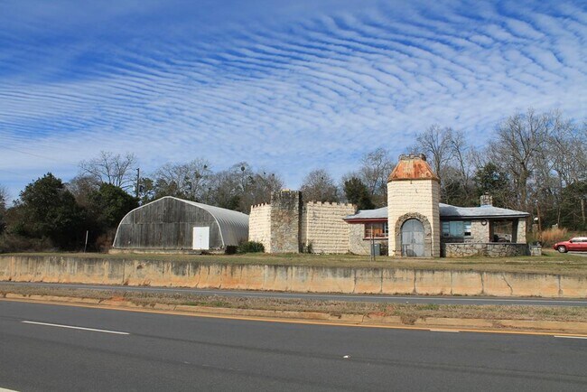
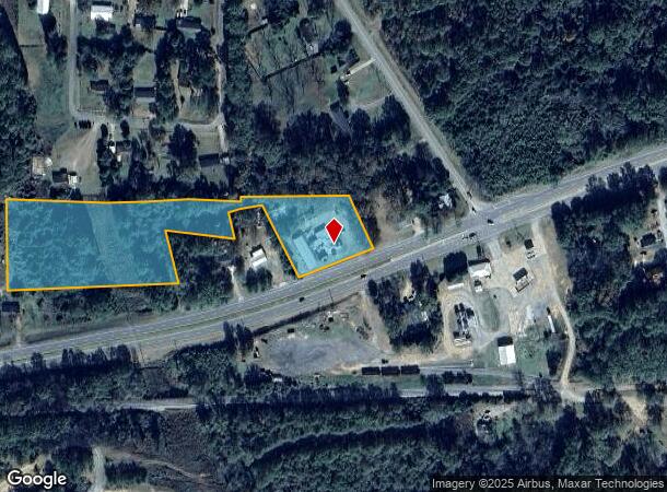
220 Us Highway 280 W, Americus, GA 31719
NEARBY LISTINGS FOR SALE OR LEASE
Property Detail
220 Us Highway 280 W
Americus, GA
Us Hwy 280
2702-183-5
4.76 AC LL 183 27 LD
Restaurantbuilding
Sumter
X
Georgia
13261C0134C
183
2024
4.76 AC
2024
Georgia South Area
950300
Other Market Areas
4,228 SF
DEMOGRAPHICS near 220 Us Highway 280 W
1 Mile
3 Mile
5 Mile
2024 Total Population
719
14,624
21,271
2029 Population
696
14,269
20,714
Pop Growth 2024-2029
(3.20%)
(2.43%)
(2.62%)
Average Age
41
38
38
2024 Total Households
250
5,628
8,256
HH Growth 2024-2029
(2.80%)
(2.31%)
(2.59%)
Median Household Inc
$45,625
$36,590
$37,571
Avg Household Size
2.40
2.40
2.40
2024 Avg HH Vehicles
2.00
2.00
2.00
Median Home Value
$139,743
$129,433
$133,345
Median Year Built
1980
1974
1977
Nearby Places
Map Layers
Map Styles
 Street
 Aerial
- Restaurants
- Banks
- Shops
- Fitness
- Groceries
SALE & LEASE HISTORY
LISTING DATE
SALE/LEASE

Feb 02, 2023
For Sale
Nearby Properties
Address
Land Use
TOTAL SIZE
Lot Size
Zoning
Address
Land Use
TOTAL SIZE
Lot Size
Zoning
1,326 SF
155 AC
001
Address
Land Use
TOTAL SIZE
Lot Size
Zoning
99,811 SF
5.31 AC
001
Address
Land Use
TOTAL SIZE
Lot Size
Zoning
236.60 AC
001
Address
Land Use
TOTAL SIZE
Lot Size
Zoning
1,760 SF
605.71 AC
007
Address
Land Use
TOTAL SIZE
Lot Size
Zoning
8.28 AC
001
Address
Land Use
TOTAL SIZE
Lot Size
Zoning
56,000 SF
16.05 AC
007
Address
Land Use
TOTAL SIZE
Lot Size
Zoning
66,303 SF
8.10 AC
002
Address
Land Use
TOTAL SIZE
Lot Size
Zoning
56,142 SF
1.45 AC
002
Address
Land Use
TOTAL SIZE
Lot Size
Zoning
52,000 SF
1.43 AC
001
Address
Land Use
TOTAL SIZE
Lot Size
Zoning
38,624 SF
3.76 AC
001
Address
Land Use
TOTAL SIZE
Lot Size
Zoning
12,000 SF
12.50 AC
002
Address
Land Use
TOTAL SIZE
Lot Size
Zoning
48,216 SF
9.30 AC
001
Address
Land Use
TOTAL SIZE
Lot Size
Zoning
51.90 AC
001
Address
Land Use
TOTAL SIZE
Lot Size
Zoning
1,152 SF
116.27 AC
003
Address
Land Use
TOTAL SIZE
Lot Size
Zoning
5,859 SF
14.98 AC
007
Address
Land Use
TOTAL SIZE
Lot Size
Zoning
29.50 AC
001
Address
Land Use
TOTAL SIZE
Lot Size
Zoning
29,184 SF
5 AC
001
Address
Land Use
TOTAL SIZE
Lot Size
Zoning
31,605 SF
3.90 AC
001
Address
Land Use
TOTAL SIZE
Lot Size
Zoning
22,238 SF
2.93 AC
002
Address
Land Use
TOTAL SIZE
Lot Size
Zoning
5,808 SF
10.03 AC
001
Address
Land Use
TOTAL SIZE
Lot Size
Zoning
1,228.06 AC
007
Address
Land Use
TOTAL SIZE
Lot Size
Zoning
13,516 SF
0.70 AC
002
Address
Land Use
TOTAL SIZE
Lot Size
Zoning
9.76 AC
001
Address
Land Use
TOTAL SIZE
Lot Size
Zoning
27,100 SF
22.92 AC
007
Address
Land Use
TOTAL SIZE
Lot Size
Zoning
29,110 SF
1.20 AC
001
Address
Land Use
TOTAL SIZE
Lot Size
Zoning
11,824 SF
5 AC
006
Address
Land Use
TOTAL SIZE
Lot Size
Zoning
21,600 SF
8 AC
001
The World's #1 Commercial Real Estate Marketplace
Connect with us
© 2026 CoStar Group
The information above has been obtained from sources believed reliable. While we do not doubt its accuracy we have not verified it and make no guarantee, warranty or representation about it. It is your responsibility to independently confirm its accuracy and completeness. Any projections, opinions, assumptions, or estimates used are for example only and do not represent the current or future performance of the property. The value of this transaction to you depends on tax and other factors which should be evaluated by your tax, financial, and legal advisors. You and your advisors should conduct a careful, independent investigation of the property to determine to your satisfaction the suitability of the property for your needs.