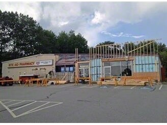
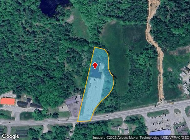
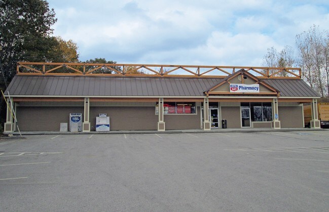
Property Record
220 Us Route 1, Bucksport, ME 04416
NEARBY LISTINGS FOR SALE OR LEASE
-
-
View all Bucksport listings for lease on LoopNet.com
Property Detail
220 Us Route 1
BUCT-000028-000000-000020
Hancock
Commercialnec
Maine
X
20
23009C0684D
1.95 AC
2024
Maine North & Bangor
2024
Other Market Areas
965300
DEMOGRAPHICS near 220 Us Route 1
1 Mile
3 Mile
5 Mile
2024 Total Population
758
3,437
5,776
2029 Population
760
3,456
5,863
Pop Growth 2024-2029
+ 0.26%
+ 0.55%
+ 1.51%
Average Age
44
45
46
2024 Total Households
337
1,539
2,569
HH Growth 2024-2029
+ 0.30%
+ 0.45%
+ 1.44%
Median Household Inc
$40,750
$52,695
$57,032
Avg Household Size
2.20
2.20
2.20
2024 Avg HH Vehicles
2.00
2.00
2.00
Median Home Value
$218,902
$197,071
$208,621
Median Year Built
1968
1969
1972
Nearby Places
Map Layers
Map Styles
 Street
 Aerial
- Restaurants
- Banks
- Shops
- Fitness
- Groceries
PUBLIC TRANSPORTATION
AIRPORT
Bangor International
DRIVE
WALK
Distance
Bangor International
37 min
23.3 mi
Freight Ports
Searsport, ME
DRIVE
WALK
Distance
Searsport, ME
20 min
12.6 mi
SALE & LEASE HISTORY
LISTING DATE
SALE/LEASE

Sep 25, 2016
For Lease
Sep 24, 2016
For Sale
May 02, 2017
For Lease
Nearby Properties
Address
Land Use
TOTAL SIZE
Lot Size
Zoning
Address
Land Use
TOTAL SIZE
Lot Size
Zoning
12 AC
ROUTE
Address
Land Use
TOTAL SIZE
Lot Size
Zoning
23.65 AC
VILLAG
Address
Land Use
TOTAL SIZE
Lot Size
Zoning
7.06 AC
INDUST
Address
Land Use
TOTAL SIZE
Lot Size
Zoning
RT 15
Address
Land Use
TOTAL SIZE
Lot Size
Zoning
89.30 AC
Address
Land Use
TOTAL SIZE
Lot Size
Zoning
8.54 AC
VILLAG
Address
Land Use
TOTAL SIZE
Lot Size
Zoning
11.61 AC
VILLAG
Address
Land Use
TOTAL SIZE
Lot Size
Zoning
INDUST
Address
Land Use
TOTAL SIZE
Lot Size
Zoning
INDUST
Address
Land Use
TOTAL SIZE
Lot Size
Zoning
109.20 AC
INDUST
Address
Land Use
TOTAL SIZE
Lot Size
Zoning
2.80 AC
DOWNTO
Address
Land Use
TOTAL SIZE
Lot Size
Zoning
0.86 AC
DOWNTO
Address
Land Use
TOTAL SIZE
Lot Size
Zoning
0.42 AC
VILLAG
Address
Land Use
TOTAL SIZE
Lot Size
Zoning
1.26 AC
COMMER
Address
Land Use
TOTAL SIZE
Lot Size
Zoning
336 SF
63 AC
INDUST
Address
Land Use
TOTAL SIZE
Lot Size
Zoning
1,070 SF
0.50 AC
DOWNTO
Address
Land Use
TOTAL SIZE
Lot Size
Zoning
18 AC
RA
Address
Land Use
TOTAL SIZE
Lot Size
Zoning
1.94 AC
DOWNTO
Address
Land Use
TOTAL SIZE
Lot Size
Zoning
1,992 SF
18 AC
RA
Address
Land Use
TOTAL SIZE
Lot Size
Zoning
10.80 AC
Address
Land Use
TOTAL SIZE
Lot Size
Zoning
INDUST
Address
Land Use
TOTAL SIZE
Lot Size
Zoning
2.67 AC
COMMER
Address
Land Use
TOTAL SIZE
Lot Size
Zoning
0.32 AC
DOWNTO
Address
Land Use
TOTAL SIZE
Lot Size
Zoning
1.08 AC
INDUST
Address
Land Use
TOTAL SIZE
Lot Size
Zoning
15,640 SF
0.43 AC
DOWNTO
Address
Land Use
TOTAL SIZE
Lot Size
Zoning
2,986 SF
9.38 AC
RA
Address
Land Use
TOTAL SIZE
Lot Size
Zoning
4,260 SF
1.23 AC
DOWNTO
Address
Land Use
TOTAL SIZE
Lot Size
Zoning
1.66 AC
ROUTE
Address
Land Use
TOTAL SIZE
Lot Size
Zoning
1.89 AC
VILLAG
The World's #1 Commercial Real Estate Marketplace
Connect with us
© 2025 CoStar Group
The information above has been obtained from sources believed reliable. While we do not doubt its accuracy we have not verified it and make no guarantee, warranty or representation about it. It is your responsibility to independently confirm its accuracy and completeness. Any projections, opinions, assumptions, or estimates used are for example only and do not represent the current or future performance of the property. The value of this transaction to you depends on tax and other factors which should be evaluated by your tax, financial, and legal advisors. You and your advisors should conduct a careful, independent investigation of the property to determine to your satisfaction the suitability of the property for your needs.