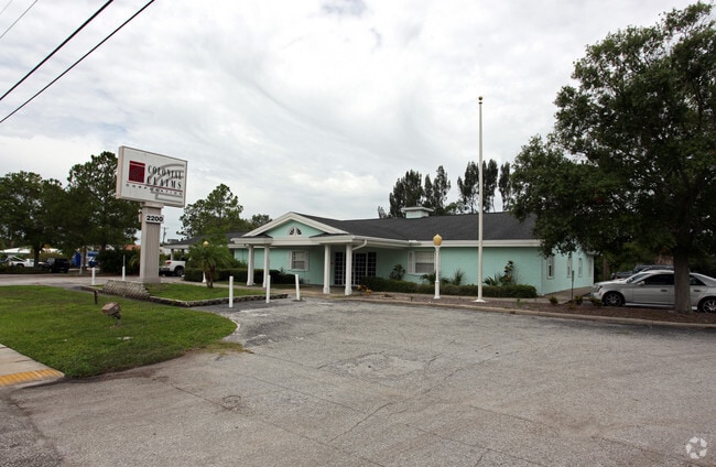
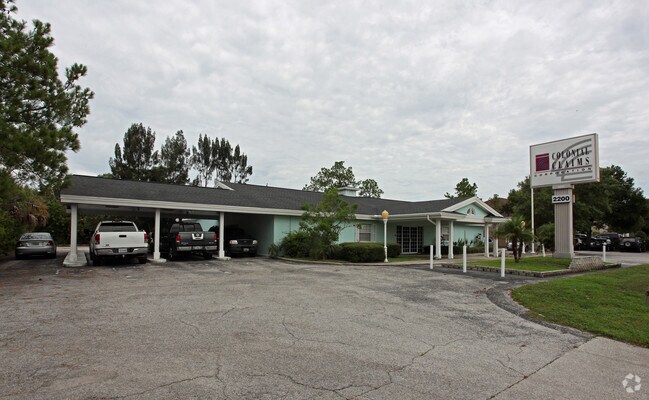
Property Record
2200 Bayshore Blvd, Dunedin, FL 34698

NEARBY LISTINGS FOR SALE OR LEASE
Property Detail
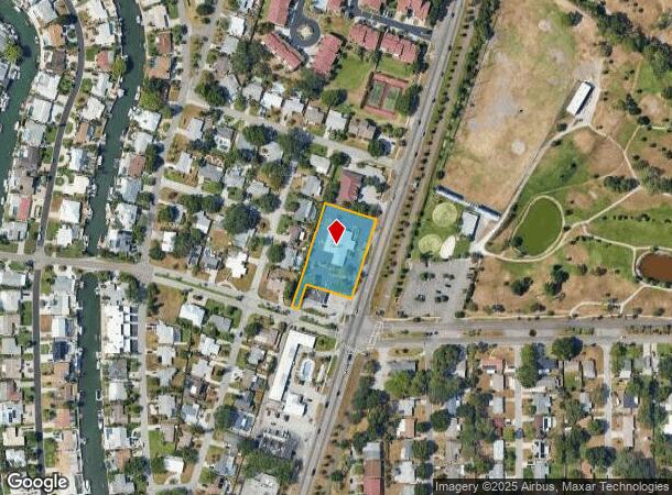
2200 Bayshore Blvd
Tampa-St. Petersburg-Clearwater, FL
Honeymoon Isle Park
15-28-15-41022-004-0020
HONEYMOON ISLE PARK BLK D, NWLY 20FT OF SELY 169FT OF SWLY 37.12FT OF LOT 1 & NELY 62.88FT OF SELY 169FT OF LOT 1 & SELY 169FT OF LOT 2 & SWLY 95.12FT OF SELY 169 FT OF LOT 3 & 20FT X 42.88 FT OF VAC R/W LYING S OF NWLY 20FT OF LOT 1
Officebuilding
Pinellas
AE
Florida
12103C0066H
1
2024
1.05 AC
2025
North Pinellas
027106
Tampa/St Petersburg
6,700 SF
DEMOGRAPHICS near 2200 Bayshore Blvd
1 Mile
3 Mile
5 Mile
2024 Total Population
6,672
57,083
160,926
2029 Population
6,775
57,191
161,125
Pop Growth 2024-2029
+ 1.54%
+ 0.19%
+ 0.12%
Average Age
55
50
49
2024 Total Households
3,425
27,415
74,711
HH Growth 2024-2029
+ 1.58%
+ 0.12%
+ 0.05%
Median Household Inc
$65,574
$60,400
$60,683
Avg Household Size
1.90
2.00
2.10
2024 Avg HH Vehicles
2.00
2.00
2.00
Median Home Value
$347,027
$317,976
$295,566
Median Year Built
1974
1977
1979
Nearby Places
Map Layers
Map Styles
 Street
 Aerial
- Restaurants
- Banks
- Shops
- Fitness
- Groceries
PUBLIC TRANSPORTATION
AIRPORT
St Pete-Clearwater International
DRIVE
WALK
Distance
St Pete-Clearwater International
25 min
15.2 mi
Tampa International
DRIVE
WALK
Distance
Tampa International
36 min
19.7 mi
Freight Ports
Port of Tampa Bay
DRIVE
WALK
Distance
Port of Tampa Bay
50 min
28.1 mi
Nearby Properties
Address
Land Use
TOTAL SIZE
Lot Size
Zoning
Address
Land Use
TOTAL SIZE
Lot Size
Zoning
167,201 SF
63.11 AC
AE
Address
Land Use
TOTAL SIZE
Lot Size
Zoning
406,729 SF
29.79 AC
CP1
Address
Land Use
TOTAL SIZE
Lot Size
Zoning
412,099 SF
49.21 AC
Address
Land Use
TOTAL SIZE
Lot Size
Zoning
242,708 SF
26.17 AC
RPD10
Address
Land Use
TOTAL SIZE
Lot Size
Zoning
362,238 SF
13.80 AC
Address
Land Use
TOTAL SIZE
Lot Size
Zoning
4,250 SF
235.09 AC
Address
Land Use
TOTAL SIZE
Lot Size
Zoning
117,024 SF
56.52 AC
Address
Land Use
TOTAL SIZE
Lot Size
Zoning
161,404 SF
18.48 AC
CP2
Address
Land Use
TOTAL SIZE
Lot Size
Zoning
191,375 SF
13.58 AC
AE
Address
Land Use
TOTAL SIZE
Lot Size
Zoning
199,825 SF
22.75 AC
R2
Address
Land Use
TOTAL SIZE
Lot Size
Zoning
250,113 SF
39.50 AC
Address
Land Use
TOTAL SIZE
Lot Size
Zoning
196,808 SF
12.70 AC
Address
Land Use
TOTAL SIZE
Lot Size
Zoning
201,208 SF
2.16 AC
Address
Land Use
TOTAL SIZE
Lot Size
Zoning
173,160 SF
5.39 AC
Address
Land Use
TOTAL SIZE
Lot Size
Zoning
107,766 SF
25.15 AC
Address
Land Use
TOTAL SIZE
Lot Size
Zoning
158,400 SF
9.80 AC
Address
Land Use
TOTAL SIZE
Lot Size
Zoning
396,841 SF
9.73 AC
Address
Land Use
TOTAL SIZE
Lot Size
Zoning
415,593 SF
29.66 AC
Address
Land Use
TOTAL SIZE
Lot Size
Zoning
92,817 SF
6.42 AC
PC
Address
Land Use
TOTAL SIZE
Lot Size
Zoning
76,848 SF
12.60 AC
AE
Address
Land Use
TOTAL SIZE
Lot Size
Zoning
105,830 SF
10.84 AC
CP2
Address
Land Use
TOTAL SIZE
Lot Size
Zoning
85,666 SF
4.50 AC
R2
Address
Land Use
TOTAL SIZE
Lot Size
Zoning
90,791 SF
6.92 AC
Address
Land Use
TOTAL SIZE
Lot Size
Zoning
45,190 SF
12.04 AC
Address
Land Use
TOTAL SIZE
Lot Size
Zoning
97,776 SF
9.63 AC
Address
Land Use
TOTAL SIZE
Lot Size
Zoning
103,393 SF
17.68 AC
R4
Address
Land Use
TOTAL SIZE
Lot Size
Zoning
101,243 SF
5.36 AC
M1
Address
Land Use
TOTAL SIZE
Lot Size
Zoning
119,200 SF
7.75 AC
CP1
Address
Land Use
TOTAL SIZE
Lot Size
Zoning
75,044 SF
2.95 AC
Address
Land Use
TOTAL SIZE
Lot Size
Zoning
84,170 SF
9.95 AC
The World's #1 Commercial Real Estate Marketplace
Connect with us
© 2025 CoStar Group
The information above has been obtained from sources believed reliable. While we do not doubt its accuracy we have not verified it and make no guarantee, warranty or representation about it. It is your responsibility to independently confirm its accuracy and completeness. Any projections, opinions, assumptions, or estimates used are for example only and do not represent the current or future performance of the property. The value of this transaction to you depends on tax and other factors which should be evaluated by your tax, financial, and legal advisors. You and your advisors should conduct a careful, independent investigation of the property to determine to your satisfaction the suitability of the property for your needs.