Property Record
2200 Branding Iron, Silt, CO 81652
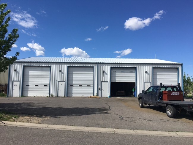


Property Detail
2200 Branding Iron
Rifle, CO
SECTION: 11 TOWNSHIP: 6 RANGE: 92 SUBDIVISION: LYON SUB PUD LOT: 149 RESUB OF LOTS 109-113 14357 SQ FT
R006246
GARFIELD
Publicstorage
Colorado
B and X Area of moderate flood hazard, usually the area between the limits of the 100-year and 500-year floods.
109,149
2024
0.33 AC
2024
Colorado Northwest Area
951901
Other Market Areas
4,800 SF
NEARBY LISTINGS FOR SALE OR LEASE
-
-
View all Silt listings for sale on LoopNet.com
DEMOGRAPHICS near 2200 Branding Iron
1 mile
3 mile
5 mile
2025 Total Population
2,446
5,362
7,594
2030 Population
2,510
5,465
7,687
Pop Growth 2025-2030
+ 2.62%
+ 1.92%
+ 1.22%
Average Age
35
37
37
2025 Total Households
810
1,811
2,597
HH Growth 2025-2030
+ 2.59%
+ 1.93%
+ 1.19%
Median Household Inc
$110,616
$104,305
$94,771
Avg Household Size
3.00
3.00
2.90
2025 Avg HH Vehicles
3.00
3.00
3.00
Median Home Value
$494,736
$558,385
$547,971
Median Year Built
2001
1997
1995
Nearby Places
Map Layers
Map Styles
 Street
 Aerial
Transit
 Traffic
 Biking
Places
Listings with unknown addresses are not visible on the map
- Restaurants
- Banks
- Shops
- Fitness
- Groceries
SALE & LEASE HISTORY
LISTING DATE
SALE/LEASE

May 30, 2017
For Sale
Nearby Properties
Address
Land Use
TOTAL SIZE
Lot Size
Zoning
Address
Land Use
TOTAL SIZE
Lot Size
Zoning
7,228 SF
253.76 AC
Address
Land Use
TOTAL SIZE
Lot Size
Zoning
12.63 AC
R
Address
Land Use
TOTAL SIZE
Lot Size
Zoning
88,377 SF
20.59 AC
ROW
Address
Land Use
TOTAL SIZE
Lot Size
Zoning
4,000 SF
5.22 AC
Address
Land Use
TOTAL SIZE
Lot Size
Zoning
3,431 SF
1.37 AC
ROW
Address
Land Use
TOTAL SIZE
Lot Size
Zoning
19,343 SF
3.51 AC
ROW
Address
Land Use
TOTAL SIZE
Lot Size
Zoning
41,652 SF
0.48 AC
Address
Land Use
TOTAL SIZE
Lot Size
Zoning
8.95 AC
CG
Address
Land Use
TOTAL SIZE
Lot Size
Zoning
4,644 SF
56.05 AC
R
Address
Land Use
TOTAL SIZE
Lot Size
Zoning
2,800 SF
0.51 AC
Address
Land Use
TOTAL SIZE
Lot Size
Zoning
3.92 AC
Address
Land Use
TOTAL SIZE
Lot Size
Zoning
9,320 SF
1.54 AC
Address
Land Use
TOTAL SIZE
Lot Size
Zoning
3.50 AC
R
Address
Land Use
TOTAL SIZE
Lot Size
Zoning
2.03 AC
CG
Address
Land Use
TOTAL SIZE
Lot Size
Zoning
17,880 SF
1.24 AC
Address
Land Use
TOTAL SIZE
Lot Size
Zoning
720 SF
27.47 AC
R
Address
Land Use
TOTAL SIZE
Lot Size
Zoning
5,040 SF
3.01 AC
R
Address
Land Use
TOTAL SIZE
Lot Size
Zoning
5,876 SF
1.50 AC
Address
Land Use
TOTAL SIZE
Lot Size
Zoning
2.63 AC
ROW
Address
Land Use
TOTAL SIZE
Lot Size
Zoning
2.55 AC
Address
Land Use
TOTAL SIZE
Lot Size
Zoning
9,100 SF
0.78 AC
ROW
Address
Land Use
TOTAL SIZE
Lot Size
Zoning
2.51 AC
Address
Land Use
TOTAL SIZE
Lot Size
Zoning
900 SF
2.08 AC
CG
Address
Land Use
TOTAL SIZE
Lot Size
Zoning
5.81 AC
R
Address
Land Use
TOTAL SIZE
Lot Size
Zoning
3.23 AC
ROW
Address
Land Use
TOTAL SIZE
Lot Size
Zoning
2.25 AC
R
Address
Land Use
TOTAL SIZE
Lot Size
Zoning
8,020 SF
0.48 AC
Address
Land Use
TOTAL SIZE
Lot Size
Zoning
3,150 SF
20.76 AC
R
Address
Land Use
TOTAL SIZE
Lot Size
Zoning
3,358 SF
0.30 AC
Address
Land Use
TOTAL SIZE
Lot Size
Zoning
7.05 AC
CL
The World's #1 Commercial Real Estate Marketplace
Connect with us
© 2026 CoStar Group
The information above has been obtained from sources believed reliable. While we do not doubt its accuracy we have not verified it and make no guarantee, warranty or representation about it. It is your responsibility to independently confirm its accuracy and completeness. Any projections, opinions, assumptions, or estimates used are for example only and do not represent the current or future performance of the property. The value of this transaction to you depends on tax and other factors which should be evaluated by your tax, financial, and legal advisors. You and your advisors should conduct a careful, independent investigation of the property to determine to your satisfaction the suitability of the property for your needs.