Property Record
2200 Chisholm Trail Rd, Round Rock, TX 78681
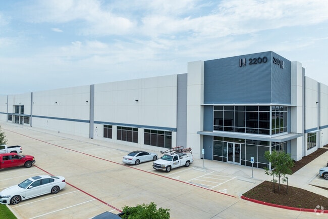

Property Detail
2200 Chisholm Trail Rd
Austin-Round Rock-San Marcos, TX
S12901 - SETTLERS GROVE, BLOCK A, LOT 2, ACRES 12.789
R629330
WILLIAMSON
Commercialnec
Texas
2024
2
2025
12.79 AC
020602
Round Rock
134,400 SF
Austin
NEARBY LISTINGS FOR SALE OR LEASE
DEMOGRAPHICS near 2200 Chisholm Trail Rd
1 mile
3 mile
5 mile
2025 Total Population
9,655
92,825
214,824
2030 Population
10,911
105,042
243,624
Pop Growth 2025-2030
+ 13.01%
+ 13.16%
+ 13.41%
Average Age
37
37
37
2025 Total Households
3,318
33,797
77,583
HH Growth 2025-2030
+ 13.47%
+ 13.74%
+ 14.00%
Median Household Inc
$129,716
$97,951
$115,441
Avg Household Size
2.90
2.70
2.70
2025 Avg HH Vehicles
2.00
2.00
2.00
Median Home Value
$561,780
$452,100
$480,746
Median Year Built
1997
1999
2004
Nearby Places
Map Layers
Map Styles
 Street
 Aerial
Transit
 Traffic
 Biking
Places
Listings with unknown addresses are not visible on the map
- Restaurants
- Banks
- Shops
- Fitness
- Groceries
PUBLIC TRANSPORTATION
AIRPORT
Austin-Bergstrom International
Drive
Walk
Distance
Austin-Bergstrom International
42 min
30.5 mi
Freight Ports
Calhoun Port
Drive
Walk
Distance
Calhoun Port
206 min
179.2 mi
SALE & LEASE HISTORY
LISTING DATE
SALE/LEASE

Jul 06, 2022
For Lease
Nearby Properties
Address
Land Use
TOTAL SIZE
Lot Size
Zoning
Address
Land Use
TOTAL SIZE
Lot Size
Zoning
489,460 SF
55.81 AC
PF3
Address
Land Use
TOTAL SIZE
Lot Size
Zoning
543,047 SF
76.14 AC
PUD
Address
Land Use
TOTAL SIZE
Lot Size
Zoning
536,741 SF
80.32 AC
SF2
Address
Land Use
TOTAL SIZE
Lot Size
Zoning
757,866 SF
33.21 AC
Address
Land Use
TOTAL SIZE
Lot Size
Zoning
325,797 SF
36.36 AC
Address
Land Use
TOTAL SIZE
Lot Size
Zoning
533,151 SF
26.90 AC
PUD
Address
Land Use
TOTAL SIZE
Lot Size
Zoning
445,321 SF
12.52 AC
Address
Land Use
TOTAL SIZE
Lot Size
Zoning
420,181 SF
18.86 AC
Address
Land Use
TOTAL SIZE
Lot Size
Zoning
456,943 SF
66.31 AC
SF2
Address
Land Use
TOTAL SIZE
Lot Size
Zoning
374,225 SF
11.58 AC
Address
Land Use
TOTAL SIZE
Lot Size
Zoning
411,020 SF
29.91 AC
PUD
Address
Land Use
TOTAL SIZE
Lot Size
Zoning
337,685 SF
14.35 AC
Address
Land Use
TOTAL SIZE
Lot Size
Zoning
140,409 SF
17.15 AC
Address
Land Use
TOTAL SIZE
Lot Size
Zoning
330,541 SF
20.90 AC
PUD
Address
Land Use
TOTAL SIZE
Lot Size
Zoning
364,432 SF
20.56 AC
MF
Address
Land Use
TOTAL SIZE
Lot Size
Zoning
409,875 SF
25.28 AC
MF
Address
Land Use
TOTAL SIZE
Lot Size
Zoning
300,061 SF
19.19 AC
Address
Land Use
TOTAL SIZE
Lot Size
Zoning
295,680 SF
16 AC
MF
Address
Land Use
TOTAL SIZE
Lot Size
Zoning
299,400 SF
15.91 AC
MF
Address
Land Use
TOTAL SIZE
Lot Size
Zoning
330,300 SF
18.58 AC
C1
Address
Land Use
TOTAL SIZE
Lot Size
Zoning
446,815 SF
30.55 AC
Address
Land Use
TOTAL SIZE
Lot Size
Zoning
285,760 SF
15.71 AC
Address
Land Use
TOTAL SIZE
Lot Size
Zoning
375,523 SF
15.43 AC
PUD
Address
Land Use
TOTAL SIZE
Lot Size
Zoning
217,013 SF
20.44 AC
Address
Land Use
TOTAL SIZE
Lot Size
Zoning
236,569 SF
26.86 AC
PUD
Address
Land Use
TOTAL SIZE
Lot Size
Zoning
395,492 SF
7.16 AC
Address
Land Use
TOTAL SIZE
Lot Size
Zoning
326,218 SF
44.54 AC
Address
Land Use
TOTAL SIZE
Lot Size
Zoning
234,510 SF
19.18 AC
Address
Land Use
TOTAL SIZE
Lot Size
Zoning
112.40 AC
PF3
Address
Land Use
TOTAL SIZE
Lot Size
Zoning
155,800 SF
107.09 AC
LI
The World's #1 Commercial Real Estate Marketplace
Connect with us
© 2026 CoStar Group
The information above has been obtained from sources believed reliable. While we do not doubt its accuracy we have not verified it and make no guarantee, warranty or representation about it. It is your responsibility to independently confirm its accuracy and completeness. Any projections, opinions, assumptions, or estimates used are for example only and do not represent the current or future performance of the property. The value of this transaction to you depends on tax and other factors which should be evaluated by your tax, financial, and legal advisors. You and your advisors should conduct a careful, independent investigation of the property to determine to your satisfaction the suitability of the property for your needs.