Property Record
2200 Dorr Rd, Howell, MI 48843
NEARBY LISTINGS FOR SALE OR LEASE
Property Detail
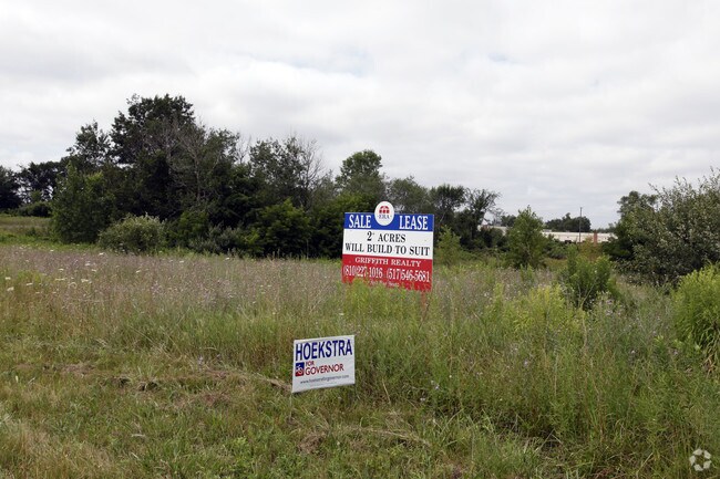
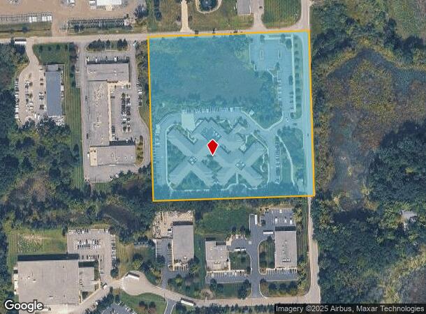
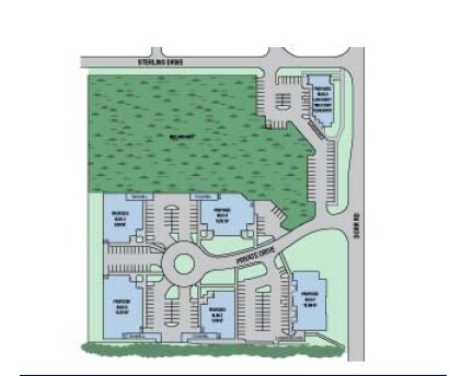
2200 Dorr Rd
11-15-200-018
T2N R5E SEC 15 SE 1/4 OF NE 1/4 OF NE 1/4. 10 AC M/L SPLIT 12/86 FR 200-030
Commercialnec
Livingston
X
Michigan
26093C0330D
10 AC
2025
Livingston County
2025
Detroit
742403
Detroit-Warren-Dearborn, MI
53,494 SF
DEMOGRAPHICS near 2200 Dorr Rd
1 Mile
3 Mile
5 Mile
2024 Total Population
2,413
17,685
53,181
2029 Population
2,490
18,190
54,730
Pop Growth 2024-2029
+ 3.19%
+ 2.86%
+ 2.91%
Average Age
46
45
44
2024 Total Households
1,075
7,338
21,190
HH Growth 2024-2029
+ 3.16%
+ 2.85%
+ 2.95%
Median Household Inc
$74,596
$88,741
$97,714
Avg Household Size
2.20
2.40
2.50
2024 Avg HH Vehicles
2.00
2.00
2.00
Median Home Value
$245,600
$338,058
$334,887
Median Year Built
1990
1991
1991
Nearby Places
Map Layers
Map Styles
 Street
 Aerial
- Restaurants
- Banks
- Shops
- Fitness
- Groceries
PUBLIC TRANSPORTATION
AIRPORT
Bishop International
DRIVE
WALK
Distance
Bishop International
43 min
34.3 mi
Capital Region International
DRIVE
WALK
Distance
Capital Region International
53 min
46.8 mi
Detroit Metro Wayne County
DRIVE
WALK
Distance
Detroit Metro Wayne County
47 min
48.0 mi
Nearby Properties
Address
Land Use
TOTAL SIZE
Lot Size
Zoning
Address
Land Use
TOTAL SIZE
Lot Size
Zoning
1,296 SF
19.42 AC
MUPUD
Address
Land Use
TOTAL SIZE
Lot Size
Zoning
172,817 SF
7.87 AC
OS
Address
Land Use
TOTAL SIZE
Lot Size
Zoning
93,620 SF
17.47 AC
MUPUD
Address
Land Use
TOTAL SIZE
Lot Size
Zoning
199,635 SF
19.85 AC
RPUD
Address
Land Use
TOTAL SIZE
Lot Size
Zoning
210,003 SF
29.17 AC
MUPUD
Address
Land Use
TOTAL SIZE
Lot Size
Zoning
173,509 SF
18.06 AC
R-M
Address
Land Use
TOTAL SIZE
Lot Size
Zoning
240,114 SF
18.91 AC
R-M
Address
Land Use
TOTAL SIZE
Lot Size
Zoning
134,148 SF
11.43 AC
IA
Address
Land Use
TOTAL SIZE
Lot Size
Zoning
60,900 SF
5.74 AC
NRPUD
Address
Land Use
TOTAL SIZE
Lot Size
Zoning
166,550 SF
20 AC
IND
Address
Land Use
TOTAL SIZE
Lot Size
Zoning
124,157 SF
13.27 AC
OR
Address
Land Use
TOTAL SIZE
Lot Size
Zoning
220,091 SF
21.88 AC
NRPUD
Address
Land Use
TOTAL SIZE
Lot Size
Zoning
110,602 SF
18.63 AC
R-M
Address
Land Use
TOTAL SIZE
Lot Size
Zoning
134,688 SF
14.97 AC
NRPUD
Address
Land Use
TOTAL SIZE
Lot Size
Zoning
113,038 SF
9.73 AC
OR
Address
Land Use
TOTAL SIZE
Lot Size
Zoning
5,947 SF
104.68 AC
MHP
Address
Land Use
TOTAL SIZE
Lot Size
Zoning
96,896 SF
12.11 AC
HDR
Address
Land Use
TOTAL SIZE
Lot Size
Zoning
80,573 SF
13.72 AC
OR
Address
Land Use
TOTAL SIZE
Lot Size
Zoning
19.60 AC
OR
Address
Land Use
TOTAL SIZE
Lot Size
Zoning
41,261 SF
1.72 AC
OS
Address
Land Use
TOTAL SIZE
Lot Size
Zoning
27,605 SF
3.82 AC
R-M
Address
Land Use
TOTAL SIZE
Lot Size
Zoning
51,408 SF
5.40 AC
OR
Address
Land Use
TOTAL SIZE
Lot Size
Zoning
25,337 SF
6.53 AC
OR
Address
Land Use
TOTAL SIZE
Lot Size
Zoning
51.99 AC
MHP
Address
Land Use
TOTAL SIZE
Lot Size
Zoning
65,560 SF
2.56 AC
NRPUD
Address
Land Use
TOTAL SIZE
Lot Size
Zoning
73,296 SF
7 AC
HDR
Address
Land Use
TOTAL SIZE
Lot Size
Zoning
116,885 SF
13.78 AC
RCD
Address
Land Use
TOTAL SIZE
Lot Size
Zoning
39,260 SF
5.52 AC
R3
Address
Land Use
TOTAL SIZE
Lot Size
Zoning
30,954 SF
1.91 AC
CD-RZ
The World's #1 Commercial Real Estate Marketplace
Connect with us
© 2026 CoStar Group
The information above has been obtained from sources believed reliable. While we do not doubt its accuracy we have not verified it and make no guarantee, warranty or representation about it. It is your responsibility to independently confirm its accuracy and completeness. Any projections, opinions, assumptions, or estimates used are for example only and do not represent the current or future performance of the property. The value of this transaction to you depends on tax and other factors which should be evaluated by your tax, financial, and legal advisors. You and your advisors should conduct a careful, independent investigation of the property to determine to your satisfaction the suitability of the property for your needs.