Property Record
2200 E Benson Rd, Sioux Falls, SD 57104
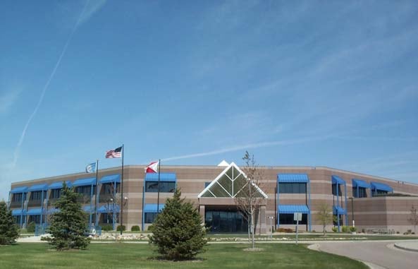

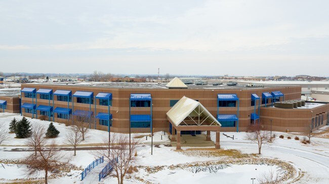

Property Detail
2200 E Benson Rd
66977
TRACT D1 (EX LOT H1) SIOUX EMPIRE DEVELOPMENT PARK FOUR ADDN TO SIOUX FALLS
Officebuilding
Minnehaha
B and X Area of moderate flood hazard, usually the area between the limits of the 100-year and 500-year floods.
South Dakota
2025
24.88 AC
2025
Sioux Falls
000100
Other Market Areas
50,160 SF
Sioux Falls, SD-MN
NEARBY LISTINGS FOR SALE OR LEASE
DEMOGRAPHICS near 2200 E Benson Rd
1 mile
3 mile
5 mile
2025 Total Population
1,620
25,897
92,346
2030 Population
1,665
27,183
97,244
Pop Growth 2025-2030
+ 2.78%
+ 4.97%
+ 5.30%
Average Age
42
39
38
2025 Total Households
659
9,688
37,826
HH Growth 2025-2030
+ 2.73%
+ 5.45%
+ 5.73%
Median Household Inc
$52,045
$65,888
$65,411
Avg Household Size
2.40
2.40
2.30
2025 Avg HH Vehicles
2.00
2.00
2.00
Median Home Value
$157,627
$224,443
$265,971
Median Year Built
1984
1986
1978
Nearby Places
Map Layers
Map Styles
 Street
 Aerial
Layers
 Traffic
 Biking
Places
Listings with unknown addresses are not visible on the map
- Restaurants
- Banks
- Shops
- Fitness
- Groceries
PUBLIC TRANSPORTATION
AIRPORT
Joe Foss Field
Drive
Walk
Distance
Joe Foss Field
22 min
6.1 mi
SALE & LEASE HISTORY
LISTING DATE
SALE/LEASE

Sep 25, 2016
For Lease
Feb 01, 2017
For Sale
Nearby Properties
Address
Land Use
TOTAL SIZE
Lot Size
Zoning
Address
Land Use
TOTAL SIZE
Lot Size
Zoning
349,950 SF
32.99 AC
Address
Land Use
TOTAL SIZE
Lot Size
Zoning
179,266 SF
1.32 AC
FP;FP
Address
Land Use
TOTAL SIZE
Lot Size
Zoning
Address
Land Use
TOTAL SIZE
Lot Size
Zoning
201,639 SF
2.30 AC
FP;FP
Address
Land Use
TOTAL SIZE
Lot Size
Zoning
14,820 SF
80.57 AC
FP;FP
Address
Land Use
TOTAL SIZE
Lot Size
Zoning
5,725 SF
77.41 AC
Address
Land Use
TOTAL SIZE
Lot Size
Zoning
227,743 SF
90.58 AC
Address
Land Use
TOTAL SIZE
Lot Size
Zoning
1.20 AC
FP;FP
Address
Land Use
TOTAL SIZE
Lot Size
Zoning
212,076 SF
41.01 AC
FP;FP
Address
Land Use
TOTAL SIZE
Lot Size
Zoning
1.57 AC
C2;GENERAL
Address
Land Use
TOTAL SIZE
Lot Size
Zoning
Address
Land Use
TOTAL SIZE
Lot Size
Zoning
123,441 SF
14.41 AC
Address
Land Use
TOTAL SIZE
Lot Size
Zoning
15,000 SF
29.88 AC
Address
Land Use
TOTAL SIZE
Lot Size
Zoning
205,572 SF
22.50 AC
Address
Land Use
TOTAL SIZE
Lot Size
Zoning
33,416 SF
9.87 AC
Address
Land Use
TOTAL SIZE
Lot Size
Zoning
171,429 SF
18.37 AC
Address
Land Use
TOTAL SIZE
Lot Size
Zoning
173,905 SF
10 AC
Address
Land Use
TOTAL SIZE
Lot Size
Zoning
62,856 SF
11.26 AC
Address
Land Use
TOTAL SIZE
Lot Size
Zoning
327,184 SF
0.94 AC
FP;FP
Address
Land Use
TOTAL SIZE
Lot Size
Zoning
122,741 SF
1.27 AC
FP;FP
Address
Land Use
TOTAL SIZE
Lot Size
Zoning
239,450 SF
21.92 AC
NO;SPECIAL
Address
Land Use
TOTAL SIZE
Lot Size
Zoning
132,353 SF
3.66 AC
FP;FP
Address
Land Use
TOTAL SIZE
Lot Size
Zoning
124,103 SF
28.18 AC
Address
Land Use
TOTAL SIZE
Lot Size
Zoning
127,500 SF
13.04 AC
Address
Land Use
TOTAL SIZE
Lot Size
Zoning
85,272 SF
4.83 AC
Address
Land Use
TOTAL SIZE
Lot Size
Zoning
103,670 SF
2.29 AC
Address
Land Use
TOTAL SIZE
Lot Size
Zoning
1,806 SF
170.92 AC
FP;FP
Address
Land Use
TOTAL SIZE
Lot Size
Zoning
120,000 SF
13.08 AC
Address
Land Use
TOTAL SIZE
Lot Size
Zoning
123,702 SF
7.03 AC
FP;FP
The World's #1 Commercial Real Estate Marketplace
Connect with us
© 2026 CoStar Group
The information above has been obtained from sources believed reliable. While we do not doubt its accuracy we have not verified it and make no guarantee, warranty or representation about it. It is your responsibility to independently confirm its accuracy and completeness. Any projections, opinions, assumptions, or estimates used are for example only and do not represent the current or future performance of the property. The value of this transaction to you depends on tax and other factors which should be evaluated by your tax, financial, and legal advisors. You and your advisors should conduct a careful, independent investigation of the property to determine to your satisfaction the suitability of the property for your needs.