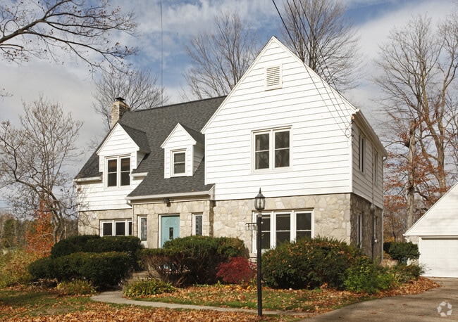
Property Record
2200 Moores River Dr, Lansing, MI 48911


NEARBY LISTINGS FOR SALE OR LEASE
Property Detail
2200 Moores River Dr
Lansing-East Lansing, MI
Cambridge Downs Subdivision
01-01-20-301-003
LOT 25, S 239 FT LOTS 22, 23 & 24, ALSO OUTLOT B EXC COM NE COR THEREOF, TH S TO N LINE OF S 239 FT SAID OUTLOT, W 40 FT, N
Countryclub
Ingham
X
Michigan
26065C0129D
22b
2024
144.53 AC
2025
Southern Lansing
001703
West Michigan
4,602 SF
DEMOGRAPHICS near 2200 Moores River Dr
1 Mile
3 Mile
5 Mile
2024 Total Population
7,865
89,057
166,141
2029 Population
7,817
88,992
166,157
Pop Growth 2024-2029
(0.61%)
(0.07%)
+ 0.01%
Average Age
40
38
38
2024 Total Households
3,476
39,115
73,251
HH Growth 2024-2029
(0.78%)
(0.13%)
(0.05%)
Median Household Inc
$62,797
$48,911
$50,851
Avg Household Size
2.20
2.20
2.20
2024 Avg HH Vehicles
1.00
1.00
2.00
Median Home Value
$135,200
$119,821
$134,544
Median Year Built
1954
1958
1965
Nearby Places
Map Layers
Map Styles
 Street
 Aerial
- Restaurants
- Banks
- Shops
- Fitness
- Groceries
PUBLIC TRANSPORTATION
COMMUTER RAIL
East Lansing Amtrak Station (Blue Water - Amtrak)
DRIVE
WALK
Distance
East Lansing Amtrak Station (Blue Water - Amtrak)
12 min
5.7 mi
AIRPORT
Capital Region International
DRIVE
WALK
Distance
Capital Region International
15 min
5.9 mi
Freight Ports
Port of Toledo
DRIVE
WALK
Distance
Port of Toledo
151 min
117.0 mi
Nearby Properties
Address
Land Use
TOTAL SIZE
Lot Size
Zoning
Address
Land Use
TOTAL SIZE
Lot Size
Zoning
111,180 SF
3.63 AC
G-1 BUS
Address
Land Use
TOTAL SIZE
Lot Size
Zoning
177,300 SF
8.72 AC
Address
Land Use
TOTAL SIZE
Lot Size
Zoning
69,851 SF
134.23 AC
I HVY
Address
Land Use
TOTAL SIZE
Lot Size
Zoning
217,664 SF
61.37 AC
NONE
Address
Land Use
TOTAL SIZE
Lot Size
Zoning
389,485 SF
30.04 AC
NONE
Address
Land Use
TOTAL SIZE
Lot Size
Zoning
185,190 SF
0.41 AC
G-1 BUS
Address
Land Use
TOTAL SIZE
Lot Size
Zoning
150,589 SF
3.06 AC
D-1 PRO
Address
Land Use
TOTAL SIZE
Lot Size
Zoning
111,804 SF
80 AC
NONE
Address
Land Use
TOTAL SIZE
Lot Size
Zoning
332,832 SF
2.48 AC
G-1 BUS
Address
Land Use
TOTAL SIZE
Lot Size
Zoning
2,276,790 SF
96.93 AC
NONE
Address
Land Use
TOTAL SIZE
Lot Size
Zoning
169,704 SF
0.67 AC
G-1 BUS
Address
Land Use
TOTAL SIZE
Lot Size
Zoning
165,684 SF
1.20 AC
G-1 BUS
Address
Land Use
TOTAL SIZE
Lot Size
Zoning
292,918 SF
I-FAC
Address
Land Use
TOTAL SIZE
Lot Size
Zoning
159,455 SF
0.42 AC
Address
Land Use
TOTAL SIZE
Lot Size
Zoning
157,548 SF
0.72 AC
Address
Land Use
TOTAL SIZE
Lot Size
Zoning
235,893 SF
18.69 AC
NONE
Address
Land Use
TOTAL SIZE
Lot Size
Zoning
114,681 SF
1.08 AC
G-1 BUS
Address
Land Use
TOTAL SIZE
Lot Size
Zoning
67,365 SF
4.19 AC
H LT IN
Address
Land Use
TOTAL SIZE
Lot Size
Zoning
Address
Land Use
TOTAL SIZE
Lot Size
Zoning
121,536 SF
2 AC
Address
Land Use
TOTAL SIZE
Lot Size
Zoning
76,606 SF
1.75 AC
Address
Land Use
TOTAL SIZE
Lot Size
Zoning
140,722 SF
1.40 AC
Address
Land Use
TOTAL SIZE
Lot Size
Zoning
14,505 SF
90 AC
Address
Land Use
TOTAL SIZE
Lot Size
Zoning
78,000 SF
0.18 AC
G-1 BUS
Address
Land Use
TOTAL SIZE
Lot Size
Zoning
106,344 SF
10.69 AC
NONE
Address
Land Use
TOTAL SIZE
Lot Size
Zoning
250,100 SF
25.45 AC
NONE
Address
Land Use
TOTAL SIZE
Lot Size
Zoning
101,893 SF
0.40 AC
G-1 BUS
Address
Land Use
TOTAL SIZE
Lot Size
Zoning
72,188 SF
1.45 AC
Address
Land Use
TOTAL SIZE
Lot Size
Zoning
269,800 SF
20.10 AC
NONE
Address
Land Use
TOTAL SIZE
Lot Size
Zoning
200,072 SF
23.85 AC
NONE
The World's #1 Commercial Real Estate Marketplace
Connect with us
© 2026 CoStar Group
The information above has been obtained from sources believed reliable. While we do not doubt its accuracy we have not verified it and make no guarantee, warranty or representation about it. It is your responsibility to independently confirm its accuracy and completeness. Any projections, opinions, assumptions, or estimates used are for example only and do not represent the current or future performance of the property. The value of this transaction to you depends on tax and other factors which should be evaluated by your tax, financial, and legal advisors. You and your advisors should conduct a careful, independent investigation of the property to determine to your satisfaction the suitability of the property for your needs.