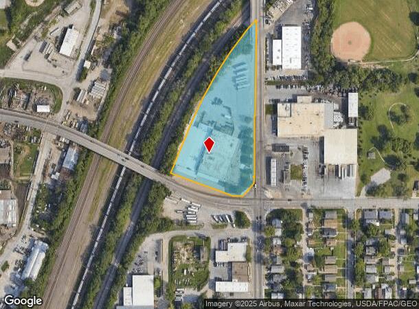
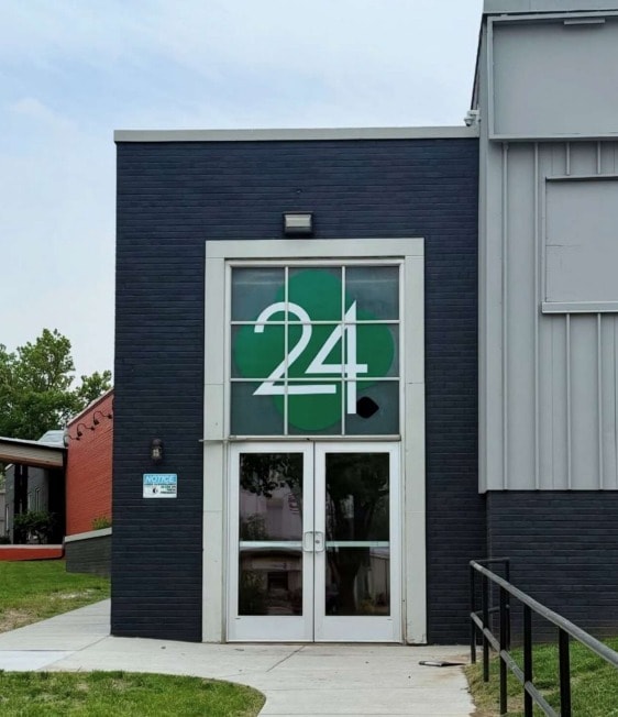
Property Record
2200 S 24Th St, Omaha, NE 68108

Current Lease Availabilities
NEARBY LISTINGS FOR SALE OR LEASE
Property Detail
2200 S 24Th St
Omaha-Council Bluffs, NE-IA
Lands
2453-0000-02
LANDS SEC-TWN-RGE 28-15-13 -EX PT DESC WD 1868-523 & 1879-386- E OF C B & Q RR & N OF ED CREIGHTON AVE TAX LT 7 NE 1/4 SE 1/4
Warehouse
Douglas
X
Nebraska
31153C0080G
7
2024
3.41 AC
2025
Southeast Omaha
002000
Omaha/Council Bluffs
81,908 SF
DEMOGRAPHICS near 2200 S 24Th St
1 Mile
3 Mile
5 Mile
2024 Total Population
22,103
124,382
262,093
2029 Population
22,515
126,854
266,984
Pop Growth 2024-2029
+ 1.86%
+ 1.99%
+ 1.87%
Average Age
34
35
36
2024 Total Households
7,759
50,901
103,641
HH Growth 2024-2029
+ 2.09%
+ 2.27%
+ 2.00%
Median Household Inc
$44,219
$49,307
$52,310
Avg Household Size
2.70
2.30
2.40
2024 Avg HH Vehicles
2.00
2.00
2.00
Median Home Value
$160,285
$164,881
$158,755
Median Year Built
1947
1951
1955
Nearby Places
Map Layers
Map Styles
 Street
 Aerial
- Restaurants
- Banks
- Shops
- Fitness
- Groceries
PUBLIC TRANSPORTATION
COMMUTER RAIL
DRIVE
WALK
Distance
4 min
1.8 mi
DRIVE
WALK
Distance
4 min
1.9 mi
AIRPORT
Eppley Airfield
DRIVE
WALK
Distance
Eppley Airfield
14 min
6.3 mi
Nearby Properties
Address
Land Use
TOTAL SIZE
Lot Size
Zoning
Address
Land Use
TOTAL SIZE
Lot Size
Zoning
1,068,760 SF
1.72 AC
Address
Land Use
TOTAL SIZE
Lot Size
Zoning
1,318,852 SF
8.77 AC
Address
Land Use
TOTAL SIZE
Lot Size
Zoning
603,518 SF
5.55 AC
CBD
Address
Land Use
TOTAL SIZE
Lot Size
Zoning
36.26 AC
P-C
Address
Land Use
TOTAL SIZE
Lot Size
Zoning
534,110 SF
4.35 AC
Address
Land Use
TOTAL SIZE
Lot Size
Zoning
30.39 AC
P-C
Address
Land Use
TOTAL SIZE
Lot Size
Zoning
362,402 SF
1.94 AC
Address
Land Use
TOTAL SIZE
Lot Size
Zoning
318,811 SF
11.51 AC
Address
Land Use
TOTAL SIZE
Lot Size
Zoning
370,431 SF
8.57 AC
Address
Land Use
TOTAL SIZE
Lot Size
Zoning
254,306 SF
0.82 AC
Address
Land Use
TOTAL SIZE
Lot Size
Zoning
426,416 SF
1.55 AC
Address
Land Use
TOTAL SIZE
Lot Size
Zoning
16.18 AC
P-C
Address
Land Use
TOTAL SIZE
Lot Size
Zoning
1,027,620 SF
4.33 AC
Address
Land Use
TOTAL SIZE
Lot Size
Zoning
378,420 SF
0.72 AC
Address
Land Use
TOTAL SIZE
Lot Size
Zoning
276,622 SF
3.90 AC
Address
Land Use
TOTAL SIZE
Lot Size
Zoning
189,720 SF
1.22 AC
CBD
Address
Land Use
TOTAL SIZE
Lot Size
Zoning
346,816 SF
0.80 AC
Address
Land Use
TOTAL SIZE
Lot Size
Zoning
318,392 SF
7.77 AC
Address
Land Use
TOTAL SIZE
Lot Size
Zoning
4.22 AC
R-4
Address
Land Use
TOTAL SIZE
Lot Size
Zoning
319,440 SF
3.05 AC
Address
Land Use
TOTAL SIZE
Lot Size
Zoning
206,591 SF
0.60 AC
Address
Land Use
TOTAL SIZE
Lot Size
Zoning
335,431 SF
0.79 AC
Address
Land Use
TOTAL SIZE
Lot Size
Zoning
27.38 AC
I-2
Address
Land Use
TOTAL SIZE
Lot Size
Zoning
10.91 AC
R-3
Address
Land Use
TOTAL SIZE
Lot Size
Zoning
140,130 SF
1.89 AC
Address
Land Use
TOTAL SIZE
Lot Size
Zoning
149,737 SF
1.93 AC
Address
Land Use
TOTAL SIZE
Lot Size
Zoning
274,024 SF
1.46 AC
Address
Land Use
TOTAL SIZE
Lot Size
Zoning
254,548 SF
1.67 AC
Address
Land Use
TOTAL SIZE
Lot Size
Zoning
198,447 SF
1.36 AC
The World's #1 Commercial Real Estate Marketplace
Connect with us
© 2026 CoStar Group
The information above has been obtained from sources believed reliable. While we do not doubt its accuracy we have not verified it and make no guarantee, warranty or representation about it. It is your responsibility to independently confirm its accuracy and completeness. Any projections, opinions, assumptions, or estimates used are for example only and do not represent the current or future performance of the property. The value of this transaction to you depends on tax and other factors which should be evaluated by your tax, financial, and legal advisors. You and your advisors should conduct a careful, independent investigation of the property to determine to your satisfaction the suitability of the property for your needs.