Property Record
2200 Us Highway 441 Se, Okeechobee, FL 34974
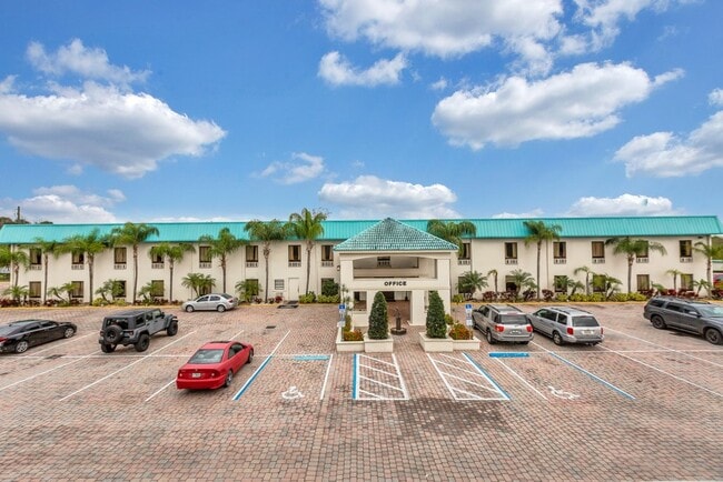
This Property Is For Sale
NEARBY LISTINGS FOR SALE OR LEASE
-
-
View all Okeechobee listings for sale on LoopNet.com
Property Detail
2200 Us Highway 441 Se
R1-35-37-35-0A00-00011-B000
Taylor Crk Isles Sec 05
Hotel
A PORTION OF SECTION 35, TOWNSHIP 37 SOUTH, RANGE 35 EAST AND A PORTION OF THE LAND LYING SOUTH OF SAID SECTION 35 BETWEEN THE HANCOCK MEANDER LINE AND THE 17 FOOT CONTOUR LINE OF LAKE OKEECHOBEE AND A PORTION OF PERMANENTLY RECLAIMED LAKE BOTTOM LAN
AE
Okeechobee
12043C0100D
Florida
2025
8.66 AC
2025
Florida Central South Area
910500
Other Market Areas
51,475 SF
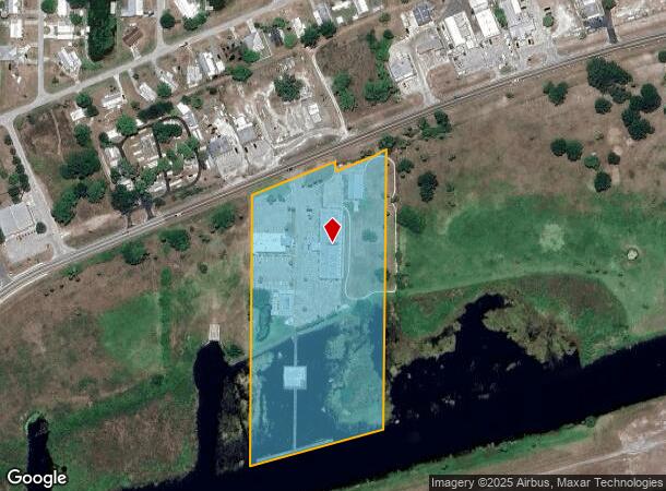
Okeechobee, FL
DEMOGRAPHICS near 2200 Us Highway 441 Se
1 Mile
3 Mile
5 Mile
2024 Total Population
2,883
13,560
24,823
2029 Population
3,111
14,563
26,529
Pop Growth 2024-2029
+ 7.91%
+ 7.40%
+ 6.87%
Average Age
49
46
43
2024 Total Households
1,363
5,964
10,041
HH Growth 2024-2029
+ 8.00%
+ 7.65%
+ 7.20%
Median Household Inc
$44,019
$41,642
$42,820
Avg Household Size
2.10
2.20
2.40
2024 Avg HH Vehicles
2.00
2.00
2.00
Median Home Value
$124,740
$126,643
$126,452
Median Year Built
1986
1987
1986
Nearby Places
Map Layers
Map Styles
 Street
 Aerial
- Restaurants
- Banks
- Shops
- Fitness
- Groceries
PUBLIC TRANSPORTATION
COMMUTER RAIL
Okeechobee Amtrak (Silver Star - Amtrak)
DRIVE
WALK
Distance
Okeechobee Amtrak (Silver Star - Amtrak)
11 min
4.6 mi
Freight Ports
Port of Palm Beach
DRIVE
WALK
Distance
Port of Palm Beach
83 min
57.5 mi
Nearby Properties
Address
Land Use
TOTAL SIZE
Lot Size
Zoning
Address
Land Use
TOTAL SIZE
Lot Size
Zoning
46,720 SF
108.57 AC
Address
Land Use
TOTAL SIZE
Lot Size
Zoning
194,141 SF
30.69 AC
Address
Land Use
TOTAL SIZE
Lot Size
Zoning
166,487 SF
40 AC
Address
Land Use
TOTAL SIZE
Lot Size
Zoning
122,024 SF
14.12 AC
Address
Land Use
TOTAL SIZE
Lot Size
Zoning
133,382 SF
1.52 AC
Address
Land Use
TOTAL SIZE
Lot Size
Zoning
90,801 SF
15.10 AC
Address
Land Use
TOTAL SIZE
Lot Size
Zoning
158,401 SF
14.89 AC
Address
Land Use
TOTAL SIZE
Lot Size
Zoning
9,262 SF
21 AC
Address
Land Use
TOTAL SIZE
Lot Size
Zoning
88,120 SF
15.30 AC
Address
Land Use
TOTAL SIZE
Lot Size
Zoning
50,633 SF
4.22 AC
Address
Land Use
TOTAL SIZE
Lot Size
Zoning
99,186 SF
7.05 AC
Address
Land Use
TOTAL SIZE
Lot Size
Zoning
9,231 SF
10.56 AC
Address
Land Use
TOTAL SIZE
Lot Size
Zoning
23,460 SF
8 AC
Address
Land Use
TOTAL SIZE
Lot Size
Zoning
77,019 SF
7.76 AC
Address
Land Use
TOTAL SIZE
Lot Size
Zoning
58,312 SF
7.50 AC
Address
Land Use
TOTAL SIZE
Lot Size
Zoning
121,250 SF
10.31 AC
Address
Land Use
TOTAL SIZE
Lot Size
Zoning
2,887 SF
11.76 AC
Address
Land Use
TOTAL SIZE
Lot Size
Zoning
9,352 SF
7.38 AC
Address
Land Use
TOTAL SIZE
Lot Size
Zoning
42,074 SF
34.62 AC
Address
Land Use
TOTAL SIZE
Lot Size
Zoning
76,008 SF
8.55 AC
Address
Land Use
TOTAL SIZE
Lot Size
Zoning
31,388 SF
11.32 AC
Address
Land Use
TOTAL SIZE
Lot Size
Zoning
66,230 SF
5.12 AC
Address
Land Use
TOTAL SIZE
Lot Size
Zoning
27,391 SF
1.08 AC
Address
Land Use
TOTAL SIZE
Lot Size
Zoning
62,297 SF
11.48 AC
Address
Land Use
TOTAL SIZE
Lot Size
Zoning
36,381 SF
2.48 AC
Address
Land Use
TOTAL SIZE
Lot Size
Zoning
3,176 SF
38.74 AC
Address
Land Use
TOTAL SIZE
Lot Size
Zoning
80,857 SF
5.48 AC
Address
Land Use
TOTAL SIZE
Lot Size
Zoning
4,293 SF
14.62 AC
Address
Land Use
TOTAL SIZE
Lot Size
Zoning
45,770 SF
7.70 AC
The World's #1 Commercial Real Estate Marketplace
Connect with us
© 2025 CoStar Group
The information above has been obtained from sources believed reliable. While we do not doubt its accuracy we have not verified it and make no guarantee, warranty or representation about it. It is your responsibility to independently confirm its accuracy and completeness. Any projections, opinions, assumptions, or estimates used are for example only and do not represent the current or future performance of the property. The value of this transaction to you depends on tax and other factors which should be evaluated by your tax, financial, and legal advisors. You and your advisors should conduct a careful, independent investigation of the property to determine to your satisfaction the suitability of the property for your needs.