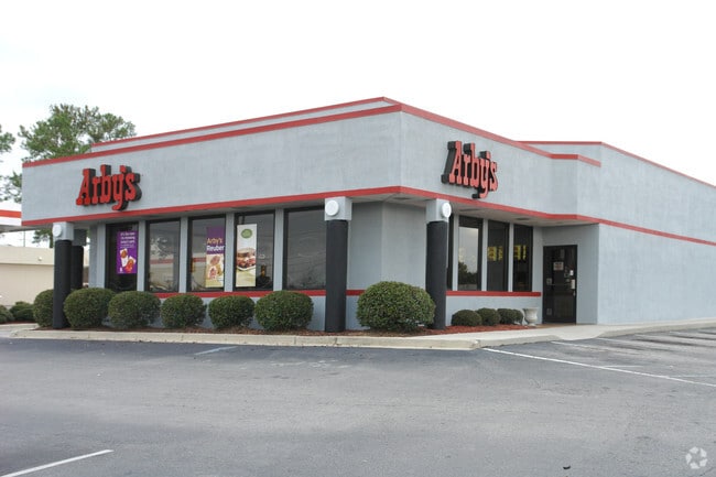
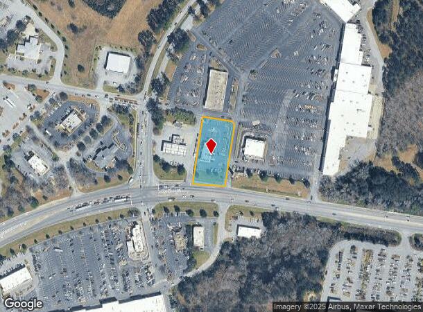
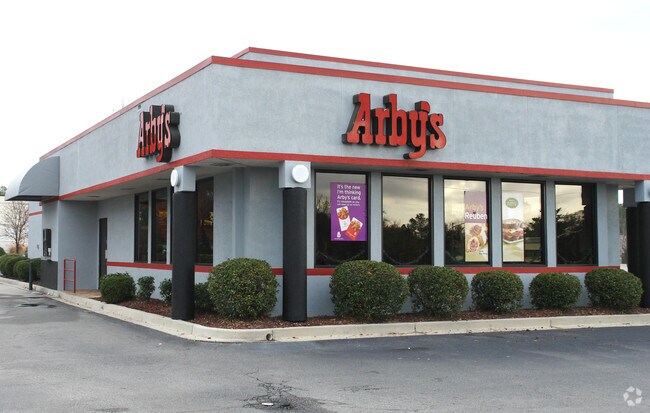
Property Record
2200 W Dekalb St, Camden, SC 29020
NEARBY LISTINGS FOR SALE OR LEASE
Property Detail
2200 W Dekalb St
C283-00-00-045
ATI EXEMPTION - GRANTED TY16 FOR $1,077,034
Restaurantdrivein
Kershaw
X
South Carolina
45055C0319F
0.90 AC
2025
Kershaw County
2025
Columbia
970500
Columbia, SC
2,815 SF
DEMOGRAPHICS near 2200 W Dekalb St
1 Mile
3 Mile
5 Mile
2024 Total Population
398
10,894
23,869
2029 Population
438
11,946
26,067
Pop Growth 2024-2029
+ 10.05%
+ 9.66%
+ 9.21%
Average Age
41
42
42
2024 Total Households
161
4,576
9,844
HH Growth 2024-2029
+ 9.94%
+ 9.48%
+ 9.08%
Median Household Inc
$36,029
$39,584
$42,375
Avg Household Size
2.30
2.30
2.30
2024 Avg HH Vehicles
1.00
2.00
2.00
Median Home Value
$189,999
$192,361
$166,724
Median Year Built
1978
1976
1981
Nearby Places
Map Layers
Map Styles
 Street
 Aerial
- Restaurants
- Banks
- Shops
- Fitness
- Groceries
PUBLIC TRANSPORTATION
COMMUTER RAIL
DRIVE
WALK
Distance
4 min
1.3 mi
AIRPORT
Columbia Metro
DRIVE
WALK
Distance
Columbia Metro
63 min
42.0 mi
Nearby Properties
Address
Land Use
TOTAL SIZE
Lot Size
Zoning
Address
Land Use
TOTAL SIZE
Lot Size
Zoning
183,825 SF
20.09 AC
MUNICIPAL
Address
Land Use
TOTAL SIZE
Lot Size
Zoning
117,844 SF
12.21 AC
MUNICIPAL
Address
Land Use
TOTAL SIZE
Lot Size
Zoning
116,508 SF
14.91 AC
MUNICIPAL
Address
Land Use
TOTAL SIZE
Lot Size
Zoning
101,650 SF
8.48 AC
Address
Land Use
TOTAL SIZE
Lot Size
Zoning
85,915 SF
3.57 AC
MUNICIPAL
Address
Land Use
TOTAL SIZE
Lot Size
Zoning
37,794 SF
28.77 AC
GD
Address
Land Use
TOTAL SIZE
Lot Size
Zoning
60,023 SF
5.70 AC
B2
Address
Land Use
TOTAL SIZE
Lot Size
Zoning
36,380 SF
3.61 AC
MUNICIPAL
Address
Land Use
TOTAL SIZE
Lot Size
Zoning
75,636 SF
6.28 AC
MUNICIPAL
Address
Land Use
TOTAL SIZE
Lot Size
Zoning
72,502 SF
12 AC
GD
Address
Land Use
TOTAL SIZE
Lot Size
Zoning
37,872 SF
6.53 AC
B2
Address
Land Use
TOTAL SIZE
Lot Size
Zoning
41,160 SF
3.37 AC
Address
Land Use
TOTAL SIZE
Lot Size
Zoning
15,214 SF
1.28 AC
MUNICIPAL
Address
Land Use
TOTAL SIZE
Lot Size
Zoning
71,157 SF
7.19 AC
MUNICIPAL
Address
Land Use
TOTAL SIZE
Lot Size
Zoning
66,678 SF
5.28 AC
R6
Address
Land Use
TOTAL SIZE
Lot Size
Zoning
20.23 AC
MUNICIPAL
Address
Land Use
TOTAL SIZE
Lot Size
Zoning
82,125 SF
8.42 AC
GD
Address
Land Use
TOTAL SIZE
Lot Size
Zoning
22,076 SF
3.53 AC
MUNICIPAL
Address
Land Use
TOTAL SIZE
Lot Size
Zoning
54,906 SF
4.51 AC
Address
Land Use
TOTAL SIZE
Lot Size
Zoning
8,804 SF
0.73 AC
Address
Land Use
TOTAL SIZE
Lot Size
Zoning
31,087 SF
9.63 AC
GD
Address
Land Use
TOTAL SIZE
Lot Size
Zoning
3.93 AC
B2
Address
Land Use
TOTAL SIZE
Lot Size
Zoning
80,614 SF
7.70 AC
MUNICIPAL
Address
Land Use
TOTAL SIZE
Lot Size
Zoning
91,301 SF
7.32 AC
MUNICIPAL
Address
Land Use
TOTAL SIZE
Lot Size
Zoning
64,714 SF
5.93 AC
B2
Address
Land Use
TOTAL SIZE
Lot Size
Zoning
20,359 SF
5.39 AC
RD2
Address
Land Use
TOTAL SIZE
Lot Size
Zoning
35,700 SF
2.03 AC
B2
Address
Land Use
TOTAL SIZE
Lot Size
Zoning
40,804 SF
3 AC
MUNICIPAL
Address
Land Use
TOTAL SIZE
Lot Size
Zoning
10,726 SF
1.50 AC
MUNICIPAL
Address
Land Use
TOTAL SIZE
Lot Size
Zoning
15,040 SF
2.52 AC
B2
The World's #1 Commercial Real Estate Marketplace
Connect with us
© 2025 CoStar Group
The information above has been obtained from sources believed reliable. While we do not doubt its accuracy we have not verified it and make no guarantee, warranty or representation about it. It is your responsibility to independently confirm its accuracy and completeness. Any projections, opinions, assumptions, or estimates used are for example only and do not represent the current or future performance of the property. The value of this transaction to you depends on tax and other factors which should be evaluated by your tax, financial, and legal advisors. You and your advisors should conduct a careful, independent investigation of the property to determine to your satisfaction the suitability of the property for your needs.