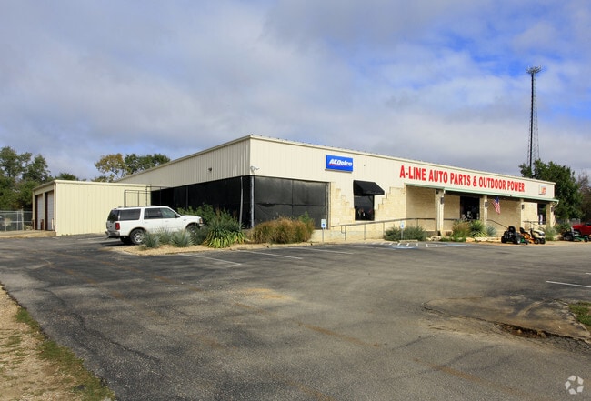
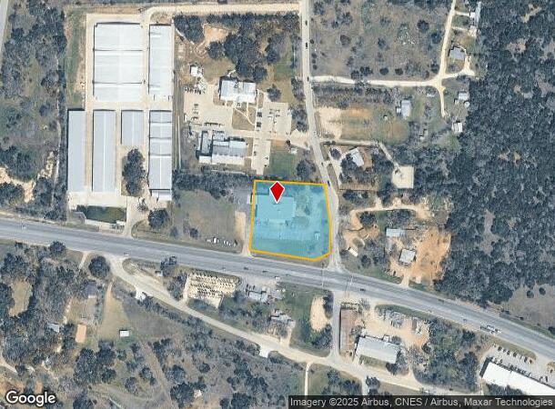
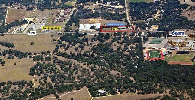
Property Record
2200 W Highway 290, Dripping Springs, TX 78620
NEARBY LISTINGS FOR SALE OR LEASE
Property Detail
2200 W Highway 290
Austin-Round Rock, TX
In Collina Subd
R87563
IN COLLINA SUBD, LOT 1, ACRES 1.7511
Commercialnec
Hays
X
Texas
48209C0105F
1
2024
1.75 AC
2025
Hays County
010817
Austin
12,538 SF
DEMOGRAPHICS near 2200 W Highway 290
1 Mile
3 Mile
5 Mile
2024 Total Population
2,832
9,825
16,191
2029 Population
3,795
13,147
21,564
Pop Growth 2024-2029
+ 34.00%
+ 33.81%
+ 33.19%
Average Age
42
41
41
2024 Total Households
1,004
3,513
5,814
HH Growth 2024-2029
+ 35.06%
+ 34.79%
+ 34.16%
Median Household Inc
$130,533
$128,333
$124,663
Avg Household Size
2.80
2.70
2.70
2024 Avg HH Vehicles
3.00
2.00
2.00
Median Home Value
$716,666
$659,298
$651,646
Median Year Built
2010
2010
2007
Nearby Places
Map Layers
Map Styles
 Street
 Aerial
- Restaurants
- Banks
- Shops
- Fitness
- Groceries
PUBLIC TRANSPORTATION
AIRPORT
Austin-Bergstrom International
DRIVE
WALK
Distance
Austin-Bergstrom International
49 min
31.6 mi
Freight Ports
Calhoun Port
DRIVE
WALK
Distance
Calhoun Port
210 min
169.8 mi
Nearby Properties
Address
Land Use
TOTAL SIZE
Lot Size
Zoning
Address
Land Use
TOTAL SIZE
Lot Size
Zoning
144,374 SF
2.51 AC
Address
Land Use
TOTAL SIZE
Lot Size
Zoning
474.73 AC
Address
Land Use
TOTAL SIZE
Lot Size
Zoning
109,839 SF
21.13 AC
Address
Land Use
TOTAL SIZE
Lot Size
Zoning
16,274 SF
22.16 AC
Address
Land Use
TOTAL SIZE
Lot Size
Zoning
79,769 SF
35.70 AC
Address
Land Use
TOTAL SIZE
Lot Size
Zoning
103,275 SF
16.53 AC
Address
Land Use
TOTAL SIZE
Lot Size
Zoning
56,828 SF
5.23 AC
Address
Land Use
TOTAL SIZE
Lot Size
Zoning
40,588 SF
5.09 AC
Address
Land Use
TOTAL SIZE
Lot Size
Zoning
204,400 SF
1.34 AC
Address
Land Use
TOTAL SIZE
Lot Size
Zoning
76,930 SF
23.87 AC
Address
Land Use
TOTAL SIZE
Lot Size
Zoning
38.01 AC
Address
Land Use
TOTAL SIZE
Lot Size
Zoning
Address
Land Use
TOTAL SIZE
Lot Size
Zoning
59,572 SF
1.56 AC
Address
Land Use
TOTAL SIZE
Lot Size
Zoning
70,096 SF
6.82 AC
Address
Land Use
TOTAL SIZE
Lot Size
Zoning
27,828 SF
2.18 AC
Address
Land Use
TOTAL SIZE
Lot Size
Zoning
Address
Land Use
TOTAL SIZE
Lot Size
Zoning
Address
Land Use
TOTAL SIZE
Lot Size
Zoning
16,500 SF
10 AC
Address
Land Use
TOTAL SIZE
Lot Size
Zoning
106,783 SF
5.79 AC
Address
Land Use
TOTAL SIZE
Lot Size
Zoning
1,781 SF
63.13 AC
Address
Land Use
TOTAL SIZE
Lot Size
Zoning
1,944 SF
5 AC
Address
Land Use
TOTAL SIZE
Lot Size
Zoning
13,064 SF
3.02 AC
Address
Land Use
TOTAL SIZE
Lot Size
Zoning
24,336 SF
2.72 AC
Address
Land Use
TOTAL SIZE
Lot Size
Zoning
53,908 SF
11.72 AC
Address
Land Use
TOTAL SIZE
Lot Size
Zoning
14,066 SF
1.99 AC
Address
Land Use
TOTAL SIZE
Lot Size
Zoning
Address
Land Use
TOTAL SIZE
Lot Size
Zoning
Address
Land Use
TOTAL SIZE
Lot Size
Zoning
13,890 SF
1.05 AC
Address
Land Use
TOTAL SIZE
Lot Size
Zoning
9,913 SF
15.01 AC
Address
Land Use
TOTAL SIZE
Lot Size
Zoning
6,298 SF
4.16 AC
The World's #1 Commercial Real Estate Marketplace
Connect with us
© 2025 CoStar Group
The information above has been obtained from sources believed reliable. While we do not doubt its accuracy we have not verified it and make no guarantee, warranty or representation about it. It is your responsibility to independently confirm its accuracy and completeness. Any projections, opinions, assumptions, or estimates used are for example only and do not represent the current or future performance of the property. The value of this transaction to you depends on tax and other factors which should be evaluated by your tax, financial, and legal advisors. You and your advisors should conduct a careful, independent investigation of the property to determine to your satisfaction the suitability of the property for your needs.