Property Record
22004 Parrotts Ferry Rd, Columbia, CA 95310
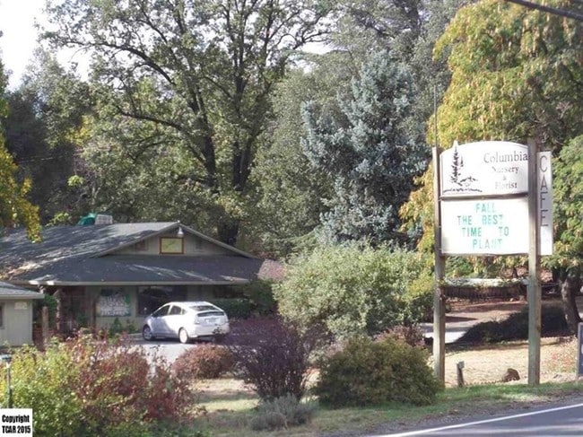
Property Detail
22004 Parrotts Ferry Rd
032-230-005-000
POR SEC 14 T2N R14E 3.365AC
Commercialnec
TUOLUMNE
C-1,D,AIR
California
B and X Area of moderate flood hazard, usually the area between the limits of the 100-year and 500-year floods.
3.37 AC
2024
Merced/Central
2025
Other Market Areas
002101
Sonora, CA
NEARBY LISTINGS FOR SALE OR LEASE
DEMOGRAPHICS near 22004 Parrotts Ferry Rd
1 mile
3 mile
5 mile
2025 Total Population
1,114
9,642
17,499
2030 Population
1,058
9,170
16,690
Pop Growth 2025-2030
(5.03%)
(4.90%)
(4.62%)
Average Age
42
44
46
2025 Total Households
460
4,229
7,654
HH Growth 2025-2030
(5.22%)
(5.32%)
(5.04%)
Median Household Inc
$65,000
$75,568
$79,253
Avg Household Size
2.20
2.20
2.20
2025 Avg HH Vehicles
2.00
2.00
2.00
Median Home Value
$367,741
$443,800
$452,702
Median Year Built
1981
1975
1979
Nearby Places
Map Layers
Map Styles
 Street
 Aerial
Transit
 Traffic
 Biking
Places
Listings with unknown addresses are not visible on the map
- Restaurants
- Banks
- Shops
- Fitness
- Groceries
SALE & LEASE HISTORY
LISTING DATE
SALE/LEASE

Sep 23, 2016
For Sale
Jan 09, 2025
For Sale
Nearby Properties
Address
Land Use
TOTAL SIZE
Lot Size
Zoning
Address
Land Use
TOTAL SIZE
Lot Size
Zoning
6.70 AC
PD
Address
Land Use
TOTAL SIZE
Lot Size
Zoning
106,879 SF
8.10 AC
R-3,D,MX
Address
Land Use
TOTAL SIZE
Lot Size
Zoning
19,388 SF
1.41 AC
C
Address
Land Use
TOTAL SIZE
Lot Size
Zoning
28,175 SF
2.08 AC
CO
Address
Land Use
TOTAL SIZE
Lot Size
Zoning
4.19 AC
R-3,MX
Address
Land Use
TOTAL SIZE
Lot Size
Zoning
4.89 AC
R-3,MX
Address
Land Use
TOTAL SIZE
Lot Size
Zoning
4.51 AC
R-3,MX
Address
Land Use
TOTAL SIZE
Lot Size
Zoning
2,498 SF
0.75 AC
PD
Address
Land Use
TOTAL SIZE
Lot Size
Zoning
23,027 SF
0.36 AC
C
Address
Land Use
TOTAL SIZE
Lot Size
Zoning
0.31 AC
PD
Address
Land Use
TOTAL SIZE
Lot Size
Zoning
9,368 SF
1.26 AC
C-1
Address
Land Use
TOTAL SIZE
Lot Size
Zoning
3 AC
R-3,MX
Address
Land Use
TOTAL SIZE
Lot Size
Zoning
3.80 AC
PD
Address
Land Use
TOTAL SIZE
Lot Size
Zoning
8,707 SF
0.33 AC
C
Address
Land Use
TOTAL SIZE
Lot Size
Zoning
9,100 SF
0.80 AC
Address
Land Use
TOTAL SIZE
Lot Size
Zoning
600 SF
3.18 AC
C-1,AIR
Address
Land Use
TOTAL SIZE
Lot Size
Zoning
9,858 SF
1.44 AC
C
Address
Land Use
TOTAL SIZE
Lot Size
Zoning
4,522 SF
2.32 AC
C-1,D,MX
Address
Land Use
TOTAL SIZE
Lot Size
Zoning
14,590 SF
1.13 AC
CO
Address
Land Use
TOTAL SIZE
Lot Size
Zoning
4,032 SF
0.67 AC
C
Address
Land Use
TOTAL SIZE
Lot Size
Zoning
18,258 SF
2.69 AC
C-O
Address
Land Use
TOTAL SIZE
Lot Size
Zoning
1.09 AC
R-2
Address
Land Use
TOTAL SIZE
Lot Size
Zoning
9,990 SF
0.47 AC
C
Address
Land Use
TOTAL SIZE
Lot Size
Zoning
20,330 SF
1.35 AC
C
Address
Land Use
TOTAL SIZE
Lot Size
Zoning
15,457 SF
0.73 AC
CO
Address
Land Use
TOTAL SIZE
Lot Size
Zoning
970 SF
0.92 AC
C
Address
Land Use
TOTAL SIZE
Lot Size
Zoning
21,800 SF
1.74 AC
C-1,D,PD
Address
Land Use
TOTAL SIZE
Lot Size
Zoning
5,092 SF
1.07 AC
R-2
Address
Land Use
TOTAL SIZE
Lot Size
Zoning
0.90 AC
CO
Address
Land Use
TOTAL SIZE
Lot Size
Zoning
7,198 SF
1.03 AC
R-1
The World's #1 Commercial Real Estate Marketplace
Connect with us
© 2026 CoStar Group
The information above has been obtained from sources believed reliable. While we do not doubt its accuracy we have not verified it and make no guarantee, warranty or representation about it. It is your responsibility to independently confirm its accuracy and completeness. Any projections, opinions, assumptions, or estimates used are for example only and do not represent the current or future performance of the property. The value of this transaction to you depends on tax and other factors which should be evaluated by your tax, financial, and legal advisors. You and your advisors should conduct a careful, independent investigation of the property to determine to your satisfaction the suitability of the property for your needs.