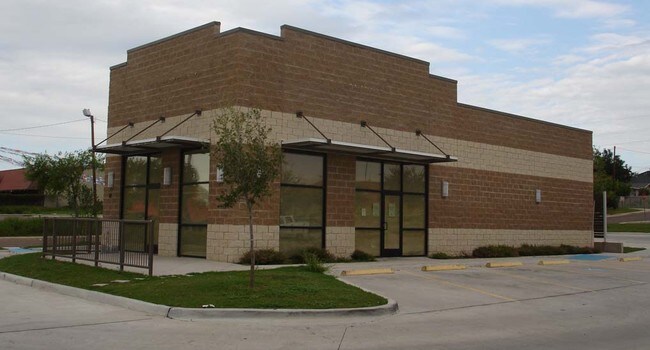
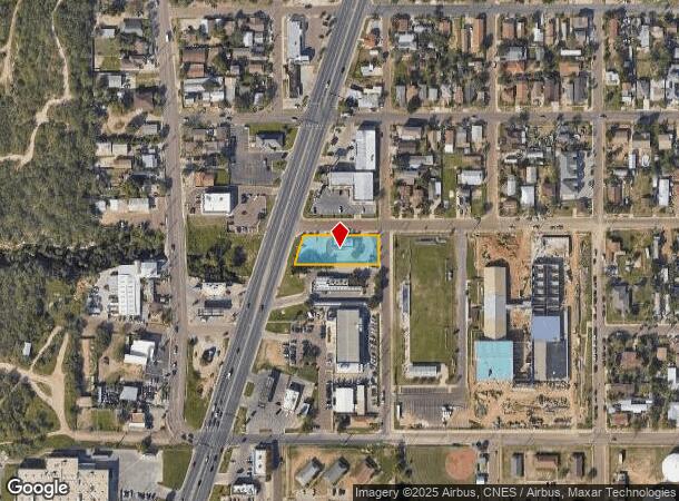
Property Record
2201 Chestnut St, Laredo, TX 78046
NEARBY LISTINGS FOR SALE OR LEASE
Property Detail
2201 Chestnut St
Laredo, TX
Eastern -- Blocks 451 - 500
171227
LOT 1 EX R/W & LOTS 2, 11, 12 BLK 461 ED
Commercialnec
Webb
X
Texas
48479C1380C
1-2
2024
0.53 AC
2025
Texas South Area
000107
Other Market Areas
1,748 SF
DEMOGRAPHICS near 2201 Chestnut St
1 Mile
3 Mile
5 Mile
2024 Total Population
15,212
104,401
167,071
2029 Population
15,173
105,497
168,759
Pop Growth 2024-2029
(0.26%)
+ 1.05%
+ 1.01%
Average Age
34
33
34
2024 Total Households
4,190
28,967
48,419
HH Growth 2024-2029
(0.24%)
+ 1.04%
+ 0.98%
Median Household Inc
$41,341
$44,145
$41,123
Avg Household Size
3.60
3.50
3.30
2024 Avg HH Vehicles
2.00
2.00
2.00
Median Home Value
$99,221
$130,244
$124,552
Median Year Built
1988
1994
1990
Nearby Places
Map Layers
Map Styles
 Street
 Aerial
- Restaurants
- Banks
- Shops
- Fitness
- Groceries
PUBLIC TRANSPORTATION
AIRPORT
Laredo International
DRIVE
WALK
Distance
Laredo International
11 min
6.1 mi
SALE & LEASE HISTORY
LISTING DATE
SALE/LEASE

Sep 25, 2016
For Lease
Nearby Properties
Address
Land Use
TOTAL SIZE
Lot Size
Zoning
Address
Land Use
TOTAL SIZE
Lot Size
Zoning
423,977 SF
1.27 AC
R2
Address
Land Use
TOTAL SIZE
Lot Size
Zoning
310,346 SF
87.65 AC
R1A
Address
Land Use
TOTAL SIZE
Lot Size
Zoning
347,773 SF
49.74 AC
R1
Address
Land Use
TOTAL SIZE
Lot Size
Zoning
689,547 SF
2.70 AC
B3
Address
Land Use
TOTAL SIZE
Lot Size
Zoning
165,608 SF
28.50 AC
R2
Address
Land Use
TOTAL SIZE
Lot Size
Zoning
231,146 SF
1.77 AC
R1
Address
Land Use
TOTAL SIZE
Lot Size
Zoning
144,491 SF
3.54 AC
CBD
Address
Land Use
TOTAL SIZE
Lot Size
Zoning
178,302 SF
45.97 AC
R3
Address
Land Use
TOTAL SIZE
Lot Size
Zoning
380,420 SF
9.18 AC
B3
Address
Land Use
TOTAL SIZE
Lot Size
Zoning
169,339 SF
28 AC
Address
Land Use
TOTAL SIZE
Lot Size
Zoning
96,991 SF
1.59 AC
CBD
Address
Land Use
TOTAL SIZE
Lot Size
Zoning
127,364 SF
1.60 AC
CBD
Address
Land Use
TOTAL SIZE
Lot Size
Zoning
137,182 SF
9.67 AC
R1
Address
Land Use
TOTAL SIZE
Lot Size
Zoning
108,994 SF
15.39 AC
Address
Land Use
TOTAL SIZE
Lot Size
Zoning
119,908 SF
11.03 AC
Address
Land Use
TOTAL SIZE
Lot Size
Zoning
183,795 SF
10.36 AC
R2
Address
Land Use
TOTAL SIZE
Lot Size
Zoning
25,104 SF
1.42 AC
CBD
Address
Land Use
TOTAL SIZE
Lot Size
Zoning
113,687 SF
5.58 AC
R3
Address
Land Use
TOTAL SIZE
Lot Size
Zoning
93,414 SF
8.57 AC
R1
Address
Land Use
TOTAL SIZE
Lot Size
Zoning
107,824 SF
13.38 AC
R1
Address
Land Use
TOTAL SIZE
Lot Size
Zoning
102,815 SF
2.23 AC
Address
Land Use
TOTAL SIZE
Lot Size
Zoning
70,980 SF
1.44 AC
CBD
Address
Land Use
TOTAL SIZE
Lot Size
Zoning
97,580 SF
3.89 AC
B1
Address
Land Use
TOTAL SIZE
Lot Size
Zoning
95,769 SF
10 AC
R1
Address
Land Use
TOTAL SIZE
Lot Size
Zoning
79,764 SF
30 AC
R1
Address
Land Use
TOTAL SIZE
Lot Size
Zoning
136,195 SF
9.50 AC
Address
Land Use
TOTAL SIZE
Lot Size
Zoning
87,789 SF
10.70 AC
Address
Land Use
TOTAL SIZE
Lot Size
Zoning
90,400 SF
1.77 AC
R3
Address
Land Use
TOTAL SIZE
Lot Size
Zoning
82,328 SF
5.12 AC
R3
Address
Land Use
TOTAL SIZE
Lot Size
Zoning
214,365 SF
18.11 AC
R2
The World's #1 Commercial Real Estate Marketplace
Connect with us
© 2026 CoStar Group
The information above has been obtained from sources believed reliable. While we do not doubt its accuracy we have not verified it and make no guarantee, warranty or representation about it. It is your responsibility to independently confirm its accuracy and completeness. Any projections, opinions, assumptions, or estimates used are for example only and do not represent the current or future performance of the property. The value of this transaction to you depends on tax and other factors which should be evaluated by your tax, financial, and legal advisors. You and your advisors should conduct a careful, independent investigation of the property to determine to your satisfaction the suitability of the property for your needs.