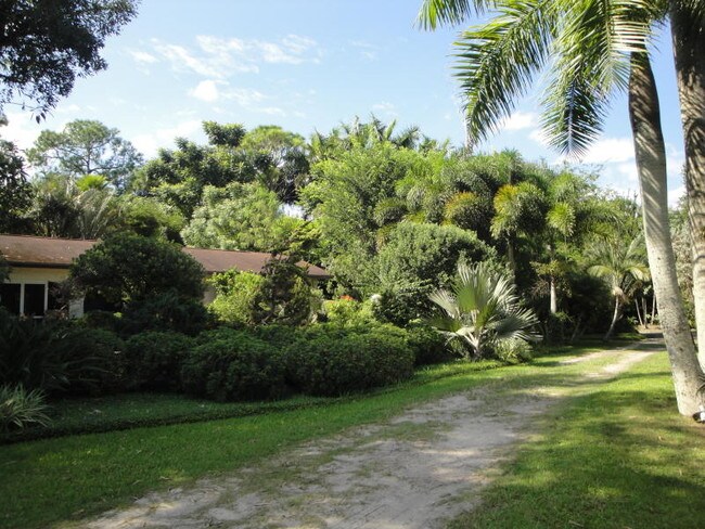
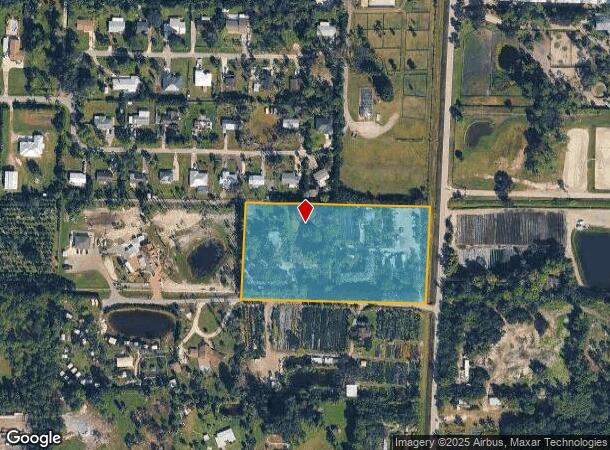
Property Record
2201 D Rd, Loxahatchee, FL 33470
NEARBY LISTINGS FOR SALE OR LEASE
Property Detail
2201 D Rd
41-41-43-17-01-343-0040
Loxahatchee Groves
Agriculturalland
LOXAHATCHEE GROVES E 1/2 OF N 1/2 OF TR 43 BLK C
AE
Palm Beach
12099C0534F
Florida
2024
5 AC
2025
Palm Bch Cty Outlying
007851
South Florida
2,037 SF
West Palm Beach-Boca Raton-Delray Beach, FL
DEMOGRAPHICS near 2201 D Rd
1 Mile
3 Mile
5 Mile
2024 Total Population
722
28,856
95,463
2029 Population
715
29,257
97,456
Pop Growth 2024-2029
(0.97%)
+ 1.39%
+ 2.09%
Average Age
42
41
40
2024 Total Households
235
9,920
32,023
HH Growth 2024-2029
(1.70%)
+ 0.73%
+ 1.39%
Median Household Inc
$96,036
$96,616
$95,408
Avg Household Size
2.90
2.80
2.80
2024 Avg HH Vehicles
2.00
2.00
2.00
Median Home Value
$498,935
$387,691
$387,639
Median Year Built
1986
1989
1990
Nearby Places
Map Layers
Map Styles
 Street
 Aerial
- Restaurants
- Banks
- Shops
- Fitness
- Groceries
PUBLIC TRANSPORTATION
AIRPORT
Palm Beach International
DRIVE
WALK
Distance
Palm Beach International
29 min
14.3 mi
Freight Ports
Port of Palm Beach
DRIVE
WALK
Distance
Port of Palm Beach
38 min
18.8 mi
SALE & LEASE HISTORY
LISTING DATE
SALE/LEASE

May 16, 2018
For Sale
Apr 18, 2018
For Sale
Nearby Properties
Address
Land Use
TOTAL SIZE
Lot Size
Zoning
Address
Land Use
TOTAL SIZE
Lot Size
Zoning
243,076 SF
15.47 AC
RM-18
Address
Land Use
TOTAL SIZE
Lot Size
Zoning
255,345 SF
15.34 AC
IPF
Address
Land Use
TOTAL SIZE
Lot Size
Zoning
81,309 SF
22.90 AC
CO
Address
Land Use
TOTAL SIZE
Lot Size
Zoning
180,760 SF
30 AC
PO
Address
Land Use
TOTAL SIZE
Lot Size
Zoning
54,192 SF
74.82 AC
AR
Address
Land Use
TOTAL SIZE
Lot Size
Zoning
79,746 SF
10.99 AC
CG
Address
Land Use
TOTAL SIZE
Lot Size
Zoning
123,753 SF
19.98 AC
PUD
Address
Land Use
TOTAL SIZE
Lot Size
Zoning
122,559 SF
15 AC
PUD
Address
Land Use
TOTAL SIZE
Lot Size
Zoning
122,338 SF
14.24 AC
CG
Address
Land Use
TOTAL SIZE
Lot Size
Zoning
98,538 SF
2.45 AC
CL
Address
Land Use
TOTAL SIZE
Lot Size
Zoning
63,826 SF
8.22 AC
CL
Address
Land Use
TOTAL SIZE
Lot Size
Zoning
103,509 SF
7.32 AC
PO
Address
Land Use
TOTAL SIZE
Lot Size
Zoning
35,390 SF
631.36 AC
MUPD
Address
Land Use
TOTAL SIZE
Lot Size
Zoning
61,105 SF
32.10 AC
AR
Address
Land Use
TOTAL SIZE
Lot Size
Zoning
69,124 SF
29.91 AC
PO
Address
Land Use
TOTAL SIZE
Lot Size
Zoning
45,875 SF
14.71 AC
PO
Address
Land Use
TOTAL SIZE
Lot Size
Zoning
34,259 SF
57.94 AC
PO
Address
Land Use
TOTAL SIZE
Lot Size
Zoning
61,566 SF
7.55 AC
CG
Address
Land Use
TOTAL SIZE
Lot Size
Zoning
73,200 SF
20 AC
PO
Address
Land Use
TOTAL SIZE
Lot Size
Zoning
51,195 SF
17 AC
RS-2
Address
Land Use
TOTAL SIZE
Lot Size
Zoning
18,515 SF
2.90 AC
MXD
Address
Land Use
TOTAL SIZE
Lot Size
Zoning
39.68 AC
R-1
Address
Land Use
TOTAL SIZE
Lot Size
Zoning
294 SF
28.79 AC
PO
Address
Land Use
TOTAL SIZE
Lot Size
Zoning
22,720 SF
1.22 AC
CG
Address
Land Use
TOTAL SIZE
Lot Size
Zoning
25,024 SF
2.32 AC
IPF
Address
Land Use
TOTAL SIZE
Lot Size
Zoning
35,263 SF
4.93 AC
MUPD
Address
Land Use
TOTAL SIZE
Lot Size
Zoning
19,263 SF
2.44 AC
MUPD
Address
Land Use
TOTAL SIZE
Lot Size
Zoning
20,370 SF
3.44 AC
CL
Address
Land Use
TOTAL SIZE
Lot Size
Zoning
15,072 SF
2.04 AC
CG
Address
Land Use
TOTAL SIZE
Lot Size
Zoning
37,588 SF
12.70 AC
MU
The World's #1 Commercial Real Estate Marketplace
Connect with us
© 2025 CoStar Group
The information above has been obtained from sources believed reliable. While we do not doubt its accuracy we have not verified it and make no guarantee, warranty or representation about it. It is your responsibility to independently confirm its accuracy and completeness. Any projections, opinions, assumptions, or estimates used are for example only and do not represent the current or future performance of the property. The value of this transaction to you depends on tax and other factors which should be evaluated by your tax, financial, and legal advisors. You and your advisors should conduct a careful, independent investigation of the property to determine to your satisfaction the suitability of the property for your needs.