Property Record
2201 Duncan Rd, Punta Gorda, FL 33982
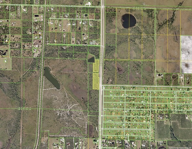
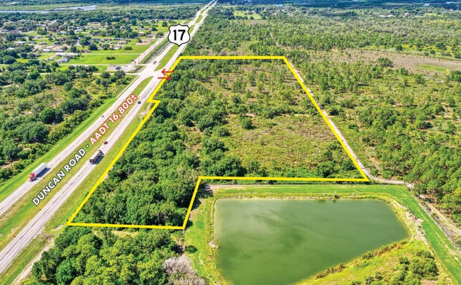
This Property Is For Sale
Property Detail
2201 Duncan Rd
Punta Gorda, FL
13 40 23 PARCEL 2-1-1 5.42 AC M/L COMM AT NE COR OF SE 1/4 SEC 13 TH W 92.86 FT TO W ROW US 17 TH S ALG ROW 707.12 FT FOR P.O.B. TH CONT S 177.27 FT TH S 23.40 FT E 36 FT S 300 FT E 10 FT S 303.43 FT TH W 305.71 FT N 798.78 FT E 269.71 FT TO P.O
402313400007
CHARLOTTE
Agriculturalland
Florida
RE1
3.38 AC
2024
Charlotte County
2025
Southwest Florida
010200
NEARBY LISTINGS FOR SALE OR LEASE
DEMOGRAPHICS near 2201 Duncan Rd
1 mile
3 mile
5 mile
2025 Total Population
530
6,472
24,985
2030 Population
619
7,203
27,519
Pop Growth 2025-2030
+ 16.79%
+ 11.29%
+ 10.14%
Average Age
48
50
51
2025 Total Households
226
2,914
11,174
HH Growth 2025-2030
+ 16.37%
+ 11.29%
+ 10.11%
Median Household Inc
$96,022
$61,186
$65,429
Avg Household Size
2.30
2.20
2.20
2025 Avg HH Vehicles
2.00
2.00
2.00
Median Home Value
$432,812
$354,536
$343,441
Median Year Built
2010
1993
1995
Nearby Places
Map Layers
Map Styles
 Street
 Aerial
Layers
 Traffic
 Biking
Places
Listings with unknown addresses are not visible on the map
- Restaurants
- Banks
- Shops
- Fitness
- Groceries
PUBLIC TRANSPORTATION
AIRPORT
Punta Gorda
Drive
Walk
Distance
Punta Gorda
13 min
8.2 mi
Freight Ports
Port Manatee
Drive
Walk
Distance
Port Manatee
90 min
76.4 mi
Nearby Properties
Address
Land Use
TOTAL SIZE
Lot Size
Zoning
Address
Land Use
TOTAL SIZE
Lot Size
Zoning
1,225,024 SF
170.84 AC
IL
Address
Land Use
TOTAL SIZE
Lot Size
Zoning
2,148 SF
121.95 AC
PD
Address
Land Use
TOTAL SIZE
Lot Size
Zoning
1,556 SF
23.08 AC
CG
Address
Land Use
TOTAL SIZE
Lot Size
Zoning
15,866 SF
63.03 AC
TTRVC
Address
Land Use
TOTAL SIZE
Lot Size
Zoning
31,194 SF
7.93 AC
CG
Address
Land Use
TOTAL SIZE
Lot Size
Zoning
16,969 SF
81.30 AC
EM
Address
Land Use
TOTAL SIZE
Lot Size
Zoning
432 SF
20 AC
A-5
Address
Land Use
TOTAL SIZE
Lot Size
Zoning
21,609 SF
20 AC
AG
Address
Land Use
TOTAL SIZE
Lot Size
Zoning
18,144 SF
2.73 AC
IG
Address
Land Use
TOTAL SIZE
Lot Size
Zoning
1,416 SF
3.85 AC
RMF5
Address
Land Use
TOTAL SIZE
Lot Size
Zoning
4,926 SF
8.10 AC
PKR
Address
Land Use
TOTAL SIZE
Lot Size
Zoning
8,823 SF
73.60 AC
RE1
Address
Land Use
TOTAL SIZE
Lot Size
Zoning
4,767 SF
0.31 AC
CG
Address
Land Use
TOTAL SIZE
Lot Size
Zoning
10,500 SF
3.43 AC
CG
Address
Land Use
TOTAL SIZE
Lot Size
Zoning
5,400 SF
7.09 AC
CG
Address
Land Use
TOTAL SIZE
Lot Size
Zoning
6,960 SF
0.86 AC
CG
Address
Land Use
TOTAL SIZE
Lot Size
Zoning
6,109 SF
2 AC
RE1
Address
Land Use
TOTAL SIZE
Lot Size
Zoning
364 SF
79.61 AC
AG
Address
Land Use
TOTAL SIZE
Lot Size
Zoning
9,219 SF
1.15 AC
CG
Address
Land Use
TOTAL SIZE
Lot Size
Zoning
532 SF
2.67 AC
RMF5
Address
Land Use
TOTAL SIZE
Lot Size
Zoning
14.03 AC
CG
Address
Land Use
TOTAL SIZE
Lot Size
Zoning
139.33 AC
ES
Address
Land Use
TOTAL SIZE
Lot Size
Zoning
1,824 SF
17.98 AC
CG
Address
Land Use
TOTAL SIZE
Lot Size
Zoning
992 SF
467.29 AC
AG
Address
Land Use
TOTAL SIZE
Lot Size
Zoning
Address
Land Use
TOTAL SIZE
Lot Size
Zoning
2,792 SF
9.60 AC
AG
Address
Land Use
TOTAL SIZE
Lot Size
Zoning
7,079 SF
2.27 AC
RMF5
Address
Land Use
TOTAL SIZE
Lot Size
Zoning
3,087 SF
1.03 AC
CG
Address
Land Use
TOTAL SIZE
Lot Size
Zoning
4,978 SF
0.57 AC
CG
Address
Land Use
TOTAL SIZE
Lot Size
Zoning
8,620 SF
21.60 AC
AG
The World's #1 Commercial Real Estate Marketplace
Connect with us
© 2026 CoStar Group
The information above has been obtained from sources believed reliable. While we do not doubt its accuracy we have not verified it and make no guarantee, warranty or representation about it. It is your responsibility to independently confirm its accuracy and completeness. Any projections, opinions, assumptions, or estimates used are for example only and do not represent the current or future performance of the property. The value of this transaction to you depends on tax and other factors which should be evaluated by your tax, financial, and legal advisors. You and your advisors should conduct a careful, independent investigation of the property to determine to your satisfaction the suitability of the property for your needs.