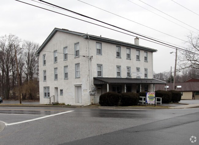
Property Record
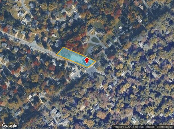
2201 Grubb Rd, Wilmington, DE 19810

NEARBY LISTINGS FOR SALE OR LEASE
-
-
View all Wilmington listings for sale on LoopNet.com
Property Detail
2201 Grubb Rd
Storebuilding
New Castle
X
Delaware
10003C0078K
0.83 AC
2024
North New Castle County
2024
Philadelphia
011204
Philadelphia-Camden-Wilmington, PA-NJ-DE-MD
2,218 SF
06-045.00-033
DEMOGRAPHICS near 2201 Grubb Rd
1 Mile
3 Mile
5 Mile
2024 Total Population
8,485
77,196
155,991
2029 Population
8,604
77,869
156,938
Pop Growth 2024-2029
+ 1.40%
+ 0.87%
+ 0.61%
Average Age
47
43
43
2024 Total Households
3,532
31,174
63,213
HH Growth 2024-2029
+ 1.44%
+ 0.94%
+ 0.63%
Median Household Inc
$100,537
$92,675
$84,599
Avg Household Size
2.30
2.40
2.40
2024 Avg HH Vehicles
2.00
2.00
2.00
Median Home Value
$365,813
$353,922
$334,623
Median Year Built
1963
1966
1965
Nearby Places
Map Layers
Map Styles
 Street
 Aerial
- Restaurants
- Banks
- Shops
- Fitness
- Groceries
PUBLIC TRANSPORTATION
COMMUTER RAIL
Claymont Transportation Center (Wilmington/Newark Line - SEPTA)
DRIVE
WALK
Distance
Claymont Transportation Center (Wilmington/Newark Line - SEPTA)
7 min
3.3 mi
Claymont (R2 - Southeastern Pennsylvania Transportation Authority Regional Rail (SEPTA Regional Rail))
DRIVE
WALK
Distance
Claymont (R2 - Southeastern Pennsylvania Transportation Authority Regional Rail (SEPTA Regional Rail))
9 min
3.3 mi
AIRPORT
Philadelphia International
DRIVE
WALK
Distance
Philadelphia International
25 min
15.4 mi
Freight Ports
Port of Wilmington, RI
DRIVE
WALK
Distance
Port of Wilmington, RI
18 min
8.9 mi
Nearby Properties
Address
Land Use
TOTAL SIZE
Lot Size
Zoning
Address
Land Use
TOTAL SIZE
Lot Size
Zoning
Address
Land Use
TOTAL SIZE
Lot Size
Zoning
15,880 SF
27.07 AC
Address
Land Use
TOTAL SIZE
Lot Size
Zoning
22,140 SF
16 AC
Address
Land Use
TOTAL SIZE
Lot Size
Zoning
199,099 SF
49 AC
S
Address
Land Use
TOTAL SIZE
Lot Size
Zoning
109,145 SF
10.57 AC
S
Address
Land Use
TOTAL SIZE
Lot Size
Zoning
162,643 SF
30.61 AC
CR
Address
Land Use
TOTAL SIZE
Lot Size
Zoning
205,529 SF
42.34 AC
S
Address
Land Use
TOTAL SIZE
Lot Size
Zoning
96,745 SF
17.07 AC
S
Address
Land Use
TOTAL SIZE
Lot Size
Zoning
128,467 SF
54.30 AC
Address
Land Use
TOTAL SIZE
Lot Size
Zoning
197,332 SF
12.13 AC
S
Address
Land Use
TOTAL SIZE
Lot Size
Zoning
122,819 SF
21.23 AC
S
Address
Land Use
TOTAL SIZE
Lot Size
Zoning
231,920 SF
23.52 AC
S
Address
Land Use
TOTAL SIZE
Lot Size
Zoning
380 SF
21.54 AC
S
Address
Land Use
TOTAL SIZE
Lot Size
Zoning
212,522 SF
16.04 AC
OR
Address
Land Use
TOTAL SIZE
Lot Size
Zoning
240,690 SF
18.44 AC
NCAP
Address
Land Use
TOTAL SIZE
Lot Size
Zoning
132,400 SF
7.79 AC
OR
Address
Land Use
TOTAL SIZE
Lot Size
Zoning
173.29 AC
Address
Land Use
TOTAL SIZE
Lot Size
Zoning
166,216 SF
5.01 AC
NCAP
Address
Land Use
TOTAL SIZE
Lot Size
Zoning
244,483 SF
10.01 AC
OR
Address
Land Use
TOTAL SIZE
Lot Size
Zoning
111,655 SF
50.62 AC
OR
Address
Land Use
TOTAL SIZE
Lot Size
Zoning
141,066 SF
36.52 AC
S
Address
Land Use
TOTAL SIZE
Lot Size
Zoning
43,332 SF
3.36 AC
CR
Address
Land Use
TOTAL SIZE
Lot Size
Zoning
359,520 SF
28.18 AC
HI
Address
Land Use
TOTAL SIZE
Lot Size
Zoning
148,870 SF
5.45 AC
OR
Address
Land Use
TOTAL SIZE
Lot Size
Zoning
124,677 SF
4.61 AC
CR
Address
Land Use
TOTAL SIZE
Lot Size
Zoning
180,096 SF
10.62 AC
ON
Address
Land Use
TOTAL SIZE
Lot Size
Zoning
41.71 AC
Address
Land Use
TOTAL SIZE
Lot Size
Zoning
222,748 SF
29.82 AC
CR
Address
Land Use
TOTAL SIZE
Lot Size
Zoning
175,804 SF
Address
Land Use
TOTAL SIZE
Lot Size
Zoning
324,733 SF
17.70 AC
NCAP
The World's #1 Commercial Real Estate Marketplace
Connect with us
© 2025 CoStar Group
The information above has been obtained from sources believed reliable. While we do not doubt its accuracy we have not verified it and make no guarantee, warranty or representation about it. It is your responsibility to independently confirm its accuracy and completeness. Any projections, opinions, assumptions, or estimates used are for example only and do not represent the current or future performance of the property. The value of this transaction to you depends on tax and other factors which should be evaluated by your tax, financial, and legal advisors. You and your advisors should conduct a careful, independent investigation of the property to determine to your satisfaction the suitability of the property for your needs.