Property Record
2201 Ne 52Nd St, Lighthouse Point, FL 33064
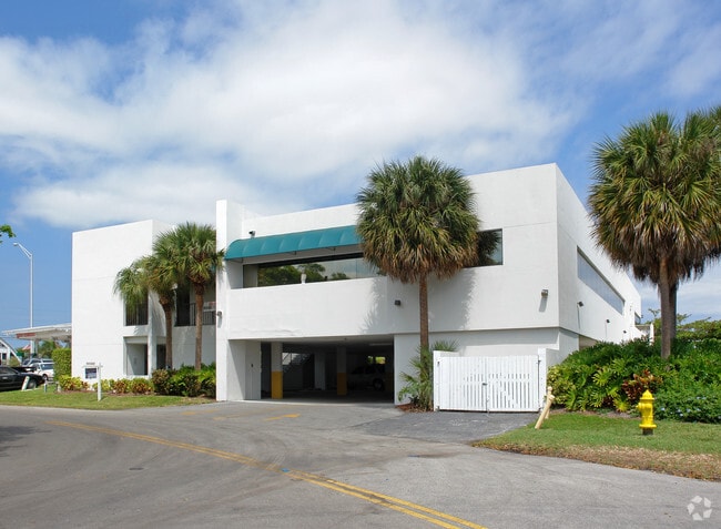

This Property Is For Sale
NEARBY LISTINGS FOR SALE OR LEASE
Property Detail
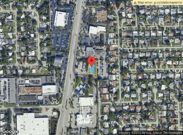
2201 Ne 52Nd St
Fort Lauderdale-Pompano Beach-Sunrise, FL
Pompano Waterway Estates 1St Add
48-43-07-14-0161
POMPANO WATERWAY ESTATES 1ST ADD 41-49 B LOT 1 LESS W 125 BLK 2 TOG WITH BUFFER PLANTING STRIP B
Officebuilding
Broward
AE
Florida
12099C1200G
1
2025
0.33 AC
2026
Pompano Beach
010102
South Florida
11,676 SF
DEMOGRAPHICS near 2201 Ne 52Nd St
1 mile
3 mile
5 mile
2024 Total Population
20,840
116,181
247,750
2029 Population
21,118
117,466
253,739
Pop Growth 2024-2029
+ 1.33%
+ 1.11%
+ 2.42%
Average Age
44
45
45
2024 Total Households
9,285
50,829
109,689
HH Growth 2024-2029
+ 1.43%
+ 1.49%
+ 2.70%
Median Household Inc
$71,369
$55,645
$60,648
Avg Household Size
2.20
2.20
2.10
2024 Avg HH Vehicles
2.00
2.00
2.00
Median Home Value
$437,267
$323,154
$375,105
Median Year Built
1971
1975
1977
Nearby Places
Map Layers
Map Styles
 Street
 Aerial
Transit
 Traffic
 Biking
Places
Listings with unknown addresses are not visible on the map
- Restaurants
- Banks
- Shops
- Fitness
- Groceries
PUBLIC TRANSPORTATION
COMMUTER RAIL
Deerfield Beach (Tri-County Commuter - South Florida Regional Transportation Authority (Tri-Rail))
Drive
Walk
Distance
Deerfield Beach (Tri-County Commuter - South Florida Regional Transportation Authority (Tri-Rail))
9 min
4.0 mi
Drive
Walk
Distance
9 min
4.3 mi
AIRPORT
Fort Lauderdale/Hollywood International
Drive
Walk
Distance
Fort Lauderdale/Hollywood International
30 min
20.6 mi
Palm Beach International
Drive
Walk
Distance
Palm Beach International
43 min
32.1 mi
Miami International
Drive
Walk
Distance
Miami International
67 min
45.8 mi
Freight Ports
Port Everglades
Drive
Walk
Distance
Port Everglades
29 min
19.3 mi
Nearby Properties
Address
Land Use
TOTAL SIZE
Lot Size
Zoning
Address
Land Use
TOTAL SIZE
Lot Size
Zoning
696,020 SF
31.74 AC
OPC
Address
Land Use
TOTAL SIZE
Lot Size
Zoning
823,639 SF
60.73 AC
PID
Address
Land Use
TOTAL SIZE
Lot Size
Zoning
1,166,083 SF
74.07 AC
I
Address
Land Use
TOTAL SIZE
Lot Size
Zoning
161,512 SF
16.39 AC
RPC
Address
Land Use
TOTAL SIZE
Lot Size
Zoning
392,222 SF
5.33 AC
RPUD
Address
Land Use
TOTAL SIZE
Lot Size
Zoning
285,335 SF
8.56 AC
RM-45
Address
Land Use
TOTAL SIZE
Lot Size
Zoning
246,122 SF
6.92 AC
TOD
Address
Land Use
TOTAL SIZE
Lot Size
Zoning
386,427 SF
2.24 AC
RM-25
Address
Land Use
TOTAL SIZE
Lot Size
Zoning
440,709 SF
22.39 AC
I
Address
Land Use
TOTAL SIZE
Lot Size
Zoning
374,776 SF
23.52 AC
I-1
Address
Land Use
TOTAL SIZE
Lot Size
Zoning
192,214 SF
10.84 AC
B-3/PCD
Address
Land Use
TOTAL SIZE
Lot Size
Zoning
435,201 SF
23.78 AC
I-1
Address
Land Use
TOTAL SIZE
Lot Size
Zoning
379,753 SF
3.30 AC
POI
Address
Land Use
TOTAL SIZE
Lot Size
Zoning
313,030 SF
37.22 AC
CF
Address
Land Use
TOTAL SIZE
Lot Size
Zoning
39,849 SF
2.48 AC
RS-2
Address
Land Use
TOTAL SIZE
Lot Size
Zoning
248,274 SF
13.10 AC
RM-20
Address
Land Use
TOTAL SIZE
Lot Size
Zoning
260,464 SF
14.82 AC
PUD
Address
Land Use
TOTAL SIZE
Lot Size
Zoning
40,896 SF
3.58 AC
RS-2
Address
Land Use
TOTAL SIZE
Lot Size
Zoning
247,079 SF
14.66 AC
I
Address
Land Use
TOTAL SIZE
Lot Size
Zoning
252,763 SF
17.03 AC
PUD
Address
Land Use
TOTAL SIZE
Lot Size
Zoning
148,780 SF
13.37 AC
B-1
Address
Land Use
TOTAL SIZE
Lot Size
Zoning
101,978 SF
0.99 AC
RM-25
Address
Land Use
TOTAL SIZE
Lot Size
Zoning
383,124 SF
23.02 AC
I
Address
Land Use
TOTAL SIZE
Lot Size
Zoning
197,145 SF
13.71 AC
PUD
Address
Land Use
TOTAL SIZE
Lot Size
Zoning
202,384 SF
12.63 AC
I-1
Address
Land Use
TOTAL SIZE
Lot Size
Zoning
13,475 SF
2.35 AC
RS-2
Address
Land Use
TOTAL SIZE
Lot Size
Zoning
194,821 SF
19.18 AC
PUD
Address
Land Use
TOTAL SIZE
Lot Size
Zoning
314,432 SF
8.97 AC
PID
Address
Land Use
TOTAL SIZE
Lot Size
Zoning
202,893 SF
12.10 AC
PUD
Address
Land Use
TOTAL SIZE
Lot Size
Zoning
16,199 SF
51.78 AC
T-1C
The World's #1 Commercial Real Estate Marketplace
Connect with us
© 2026 CoStar Group
The information above has been obtained from sources believed reliable. While we do not doubt its accuracy we have not verified it and make no guarantee, warranty or representation about it. It is your responsibility to independently confirm its accuracy and completeness. Any projections, opinions, assumptions, or estimates used are for example only and do not represent the current or future performance of the property. The value of this transaction to you depends on tax and other factors which should be evaluated by your tax, financial, and legal advisors. You and your advisors should conduct a careful, independent investigation of the property to determine to your satisfaction the suitability of the property for your needs.