Property Record
2201 Old Philadelphia Pike, Lancaster, PA 17602
NEARBY LISTINGS FOR SALE OR LEASE
Property Detail
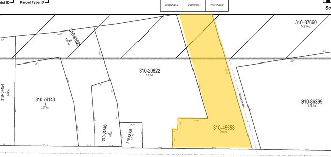
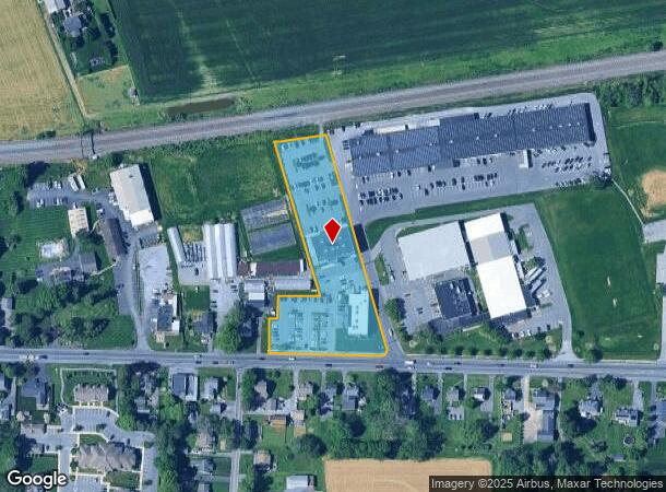
2201 Old Philadelphia Pike
310-45558-0-0000
2201 OLD PHILADELPHIA PIKE
Commercialnec
Lancaster
X
Pennsylvania
42071C0386F
1
2024
2.60 AC
2025
Lancaster County
013204
Philadelphia
36,293 SF
Lancaster, PA
DEMOGRAPHICS near 2201 Old Philadelphia Pike
1 Mile
3 Mile
5 Mile
2024 Total Population
4,187
27,929
120,731
2029 Population
4,164
28,033
121,427
Pop Growth 2024-2029
(0.55%)
+ 0.37%
+ 0.58%
Average Age
39
41
40
2024 Total Households
1,773
10,457
46,061
HH Growth 2024-2029
(0.56%)
+ 0.36%
+ 0.53%
Median Household Inc
$71,939
$82,192
$70,005
Avg Household Size
2.30
2.60
2.50
2024 Avg HH Vehicles
2.00
2.00
2.00
Median Home Value
$288,683
$280,041
$246,101
Median Year Built
1989
1984
1964
Nearby Places
Map Layers
Map Styles
 Street
 Aerial
- Restaurants
- Banks
- Shops
- Fitness
- Groceries
PUBLIC TRANSPORTATION
COMMUTER RAIL
Lancaster (Keystone Service - Amtrak, Pennsylvanian - Amtrak)
DRIVE
WALK
Distance
Lancaster (Keystone Service - Amtrak, Pennsylvanian - Amtrak)
11 min
6.4 mi
Freight Ports
Port of Wilmington, RI
DRIVE
WALK
Distance
Port of Wilmington, RI
85 min
48.8 mi
Nearby Properties
Address
Land Use
TOTAL SIZE
Lot Size
Zoning
Address
Land Use
TOTAL SIZE
Lot Size
Zoning
1,120,221 SF
8.40 AC
Address
Land Use
TOTAL SIZE
Lot Size
Zoning
403,771 SF
106.93 AC
Address
Land Use
TOTAL SIZE
Lot Size
Zoning
610,108 SF
39.96 AC
C-2
Address
Land Use
TOTAL SIZE
Lot Size
Zoning
419,136 SF
34.11 AC
Address
Land Use
TOTAL SIZE
Lot Size
Zoning
333,301 SF
24.15 AC
MU
Address
Land Use
TOTAL SIZE
Lot Size
Zoning
322,380 SF
33.29 AC
R-3
Address
Land Use
TOTAL SIZE
Lot Size
Zoning
289,398 SF
35.20 AC
C-2
Address
Land Use
TOTAL SIZE
Lot Size
Zoning
21.41 AC
Address
Land Use
TOTAL SIZE
Lot Size
Zoning
323,300 SF
21.60 AC
C-2
Address
Land Use
TOTAL SIZE
Lot Size
Zoning
125,073 SF
19.07 AC
I
Address
Land Use
TOTAL SIZE
Lot Size
Zoning
302,460 SF
51.80 AC
R4
Address
Land Use
TOTAL SIZE
Lot Size
Zoning
125,153 SF
24.10 AC
Address
Land Use
TOTAL SIZE
Lot Size
Zoning
123,445 SF
13.66 AC
I
Address
Land Use
TOTAL SIZE
Lot Size
Zoning
198,492 SF
24.74 AC
R-2
Address
Land Use
TOTAL SIZE
Lot Size
Zoning
844,700 SF
59.50 AC
I
Address
Land Use
TOTAL SIZE
Lot Size
Zoning
63,514 SF
177.90 AC
R-1
Address
Land Use
TOTAL SIZE
Lot Size
Zoning
1,137,774 SF
54.21 AC
SM
Address
Land Use
TOTAL SIZE
Lot Size
Zoning
251,051 SF
31.10 AC
R-3
Address
Land Use
TOTAL SIZE
Lot Size
Zoning
137,933 SF
16.11 AC
Address
Land Use
TOTAL SIZE
Lot Size
Zoning
111,896 SF
8.30 AC
Address
Land Use
TOTAL SIZE
Lot Size
Zoning
165,712 SF
2.41 AC
O/P
Address
Land Use
TOTAL SIZE
Lot Size
Zoning
119,442 SF
79.40 AC
PO
Address
Land Use
TOTAL SIZE
Lot Size
Zoning
19.29 AC
Address
Land Use
TOTAL SIZE
Lot Size
Zoning
258,104 SF
31.40 AC
I
Address
Land Use
TOTAL SIZE
Lot Size
Zoning
83,728 SF
2.70 AC
C-2
Address
Land Use
TOTAL SIZE
Lot Size
Zoning
172,408 SF
13.70 AC
R-3
Address
Land Use
TOTAL SIZE
Lot Size
Zoning
70,314 SF
3.20 AC
C-2
Address
Land Use
TOTAL SIZE
Lot Size
Zoning
65,964 SF
12.80 AC
A
Address
Land Use
TOTAL SIZE
Lot Size
Zoning
156,140 SF
23.50 AC
RV
Address
Land Use
TOTAL SIZE
Lot Size
Zoning
251,531 SF
42.54 AC
The World's #1 Commercial Real Estate Marketplace
Connect with us
© 2025 CoStar Group
The information above has been obtained from sources believed reliable. While we do not doubt its accuracy we have not verified it and make no guarantee, warranty or representation about it. It is your responsibility to independently confirm its accuracy and completeness. Any projections, opinions, assumptions, or estimates used are for example only and do not represent the current or future performance of the property. The value of this transaction to you depends on tax and other factors which should be evaluated by your tax, financial, and legal advisors. You and your advisors should conduct a careful, independent investigation of the property to determine to your satisfaction the suitability of the property for your needs.