Property Record
2201 Stonemont Way, Fort Worth, TX 76177


Save to a Folder
{{folder.Name}}
{{folder.ListingIds.length}} Properties
{{folder.ListingIds.length}} Property
Create a New Folder
Property Detail
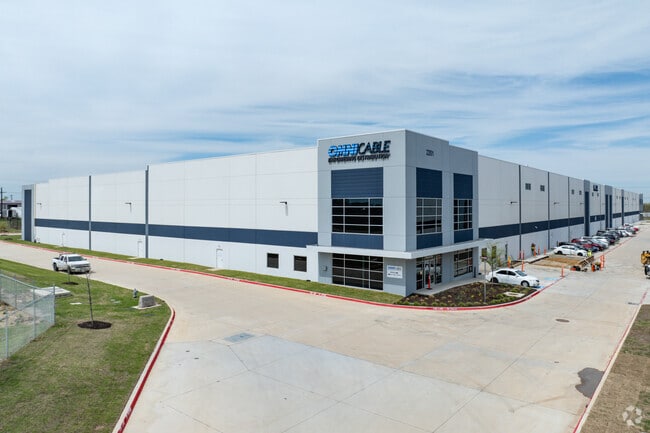
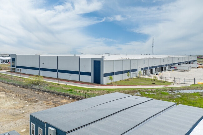
2201 Stonemont Way
Dallas-Fort Worth-Arlington, TX
STONEMONT HARMON BLOCK 1 LOT 2
42860821
TARRANT
Commercialnec
Texas
B and X Area of moderate flood hazard, usually the area between the limits of the 100-year and 500-year floods.
2
2025
12.40 AC
2025
NE Tarrant/Alliance
113932
Dallas/Ft Worth
218,400 SF
NEARBY LISTINGS FOR SALE OR LEASE
DEMOGRAPHICS near 2201 Stonemont Way
1 mile
3 mile
5 mile
2025 Total Population
3,948
75,933
209,333
2030 Population
4,203
81,115
222,757
Pop Growth 2025-2030
+ 6.46%
+ 6.82%
+ 6.41%
Average Age
37
35
35
2025 Total Households
1,378
25,133
67,801
HH Growth 2025-2030
+ 6.97%
+ 7.13%
+ 6.62%
Median Household Inc
$154,032
$116,728
$116,208
Avg Household Size
2.90
3.00
3.00
2025 Avg HH Vehicles
2.00
2.00
2.00
Median Home Value
$431,759
$390,001
$376,150
Median Year Built
2010
2010
2007
Nearby Places
Map Layers
Map Styles
 Street
 Aerial
Layers
 Traffic
 Biking
Places
Listings with unknown addresses are not visible on the map
- Restaurants
- Banks
- Shops
- Fitness
- Groceries
PUBLIC TRANSPORTATION
AIRPORT
Dallas-Fort Worth International
Drive
Walk
Distance
Dallas-Fort Worth International
35 min
24.6 mi
Dallas Love Field
Drive
Walk
Distance
Dallas Love Field
51 min
37.5 mi
Freight Ports
Port of Shreveport
Drive
Walk
Distance
Port of Shreveport
261 min
236.7 mi
SALE & LEASE HISTORY
LISTING DATE
SALE/LEASE

Jul 15, 2021
For Lease
Nearby Properties
Address
Land Use
TOTAL SIZE
Lot Size
Zoning
Address
Land Use
TOTAL SIZE
Lot Size
Zoning
348,270 SF
39.34 AC
Address
Land Use
TOTAL SIZE
Lot Size
Zoning
252,365 SF
20.53 AC
Address
Land Use
TOTAL SIZE
Lot Size
Zoning
681,942 SF
29.37 AC
Address
Land Use
TOTAL SIZE
Lot Size
Zoning
391,529 SF
17.23 AC
Address
Land Use
TOTAL SIZE
Lot Size
Zoning
1,141,133 SF
67.79 AC
Address
Land Use
TOTAL SIZE
Lot Size
Zoning
362,688 SF
34.18 AC
Address
Land Use
TOTAL SIZE
Lot Size
Zoning
266,008 SF
33 AC
Address
Land Use
TOTAL SIZE
Lot Size
Zoning
504,000 SF
26.39 AC
Address
Land Use
TOTAL SIZE
Lot Size
Zoning
882,565 SF
56.65 AC
Address
Land Use
TOTAL SIZE
Lot Size
Zoning
436,875 SF
11.14 AC
Address
Land Use
TOTAL SIZE
Lot Size
Zoning
340,366 SF
53 AC
Address
Land Use
TOTAL SIZE
Lot Size
Zoning
314,766 SF
17.34 AC
Address
Land Use
TOTAL SIZE
Lot Size
Zoning
270,000 SF
42.20 AC
Address
Land Use
TOTAL SIZE
Lot Size
Zoning
377,934 SF
16.02 AC
Address
Land Use
TOTAL SIZE
Lot Size
Zoning
372,886 SF
19.33 AC
Address
Land Use
TOTAL SIZE
Lot Size
Zoning
353,678 SF
13.57 AC
Address
Land Use
TOTAL SIZE
Lot Size
Zoning
359,225 SF
14.26 AC
Address
Land Use
TOTAL SIZE
Lot Size
Zoning
175,000 SF
14.48 AC
Address
Land Use
TOTAL SIZE
Lot Size
Zoning
308,713 SF
17.58 AC
Address
Land Use
TOTAL SIZE
Lot Size
Zoning
279,612 SF
18.46 AC
Address
Land Use
TOTAL SIZE
Lot Size
Zoning
332,287 SF
11.72 AC
Address
Land Use
TOTAL SIZE
Lot Size
Zoning
311,100 SF
17.11 AC
Address
Land Use
TOTAL SIZE
Lot Size
Zoning
727,900 SF
40.15 AC
Address
Land Use
TOTAL SIZE
Lot Size
Zoning
412,258 SF
12.62 AC
Address
Land Use
TOTAL SIZE
Lot Size
Zoning
707,940 SF
35.33 AC
Address
Land Use
TOTAL SIZE
Lot Size
Zoning
268,573 SF
11.09 AC
Address
Land Use
TOTAL SIZE
Lot Size
Zoning
677,700 SF
42.17 AC
Address
Land Use
TOTAL SIZE
Lot Size
Zoning
267,831 SF
17.40 AC
Address
Land Use
TOTAL SIZE
Lot Size
Zoning
222,672 SF
8.73 AC
Address
Land Use
TOTAL SIZE
Lot Size
Zoning
634,042 SF
35.88 AC
The World's #1 Commercial Real Estate Marketplace
Connect with us
© 2026 CoStar Group
The information above has been obtained from sources believed reliable. While we do not doubt its accuracy we have not verified it and make no guarantee, warranty or representation about it. It is your responsibility to independently confirm its accuracy and completeness. Any projections, opinions, assumptions, or estimates used are for example only and do not represent the current or future performance of the property. The value of this transaction to you depends on tax and other factors which should be evaluated by your tax, financial, and legal advisors. You and your advisors should conduct a careful, independent investigation of the property to determine to your satisfaction the suitability of the property for your needs.