Property Record
2201 W 64Th St, Hialeah, FL 33016


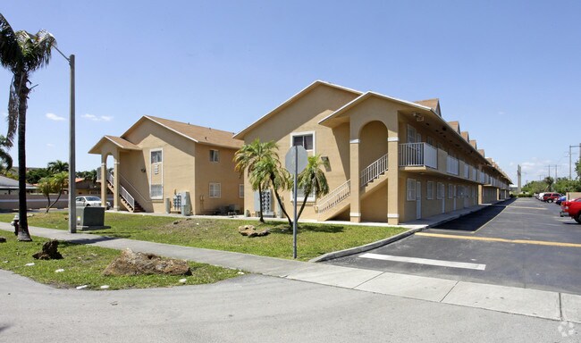
Property Detail
2201 W 64Th St
04-2034-184-0070
BARACOA NORTH PB 139-2 LOT 7 BLK 1 LOT SIZE 108526 SQ FT M/L F/A/U 04-2034-179-0010-THRU 0060 OR 16811-1729 0695 4
Multifamilydwelling
Miami-Dade
4600
Florida
AH Areas with a 1% annual chance of shallow flooding, usually in the form of a pond, withan average depth ranging from 1 to 3 feet. These areas have a 26% chance of flooding over the life of a 30-year mortgage.
7
2024
2.49 AC
2025
Hialeah
013500
South Florida
64,095 SF
Miami-Miami Beach-Kendall, FL
NEARBY LISTINGS FOR SALE OR LEASE
DEMOGRAPHICS near 2201 W 64Th St
1 mile
3 mile
5 mile
2025 Total Population
52,039
202,913
431,257
2030 Population
55,364
216,144
460,341
Pop Growth 2025-2030
+ 6.39%
+ 6.52%
+ 6.74%
Average Age
44
43
42
2025 Total Households
17,851
67,919
142,237
HH Growth 2025-2030
+ 6.36%
+ 6.47%
+ 6.68%
Median Household Inc
$51,540
$63,855
$68,868
Avg Household Size
2.90
2.90
2.90
2025 Avg HH Vehicles
2.00
2.00
2.00
Median Home Value
$306,618
$421,607
$451,720
Median Year Built
1983
1981
1983
Nearby Places
Map Layers
Map Styles
 Street
 Aerial
Layers
 Traffic
 Biking
Places
Listings with unknown addresses are not visible on the map
- Restaurants
- Banks
- Shops
- Fitness
- Groceries
PUBLIC TRANSPORTATION
COMMUTER RAIL
Palmetto (Metrorail Green Line - Miami-Dade Transit (Metrorail/Metromover))
Drive
Walk
Distance
Palmetto (Metrorail Green Line - Miami-Dade Transit (Metrorail/Metromover))
8 min
3.8 mi
Okeechobee (Metrorail Green Line - Miami-Dade Transit (Metrorail/Metromover))
Drive
Walk
Distance
Okeechobee (Metrorail Green Line - Miami-Dade Transit (Metrorail/Metromover))
9 min
4.5 mi
AIRPORT
Miami International
Drive
Walk
Distance
Miami International
18 min
8.9 mi
Fort Lauderdale/Hollywood International
Drive
Walk
Distance
Fort Lauderdale/Hollywood International
35 min
23.4 mi
Freight Ports
Port of Miami
Drive
Walk
Distance
Port of Miami
31 min
18.4 mi
Nearby Properties
Address
Land Use
TOTAL SIZE
Lot Size
Zoning
Address
Land Use
TOTAL SIZE
Lot Size
Zoning
614,708 SF
22.54 AC
4400
Address
Land Use
TOTAL SIZE
Lot Size
Zoning
636,721 SF
52.61 AC
2800
Address
Land Use
TOTAL SIZE
Lot Size
Zoning
439,520 SF
20.20 AC
9400
Address
Land Use
TOTAL SIZE
Lot Size
Zoning
725,624 SF
34.80 AC
7300
Address
Land Use
TOTAL SIZE
Lot Size
Zoning
526,059 SF
18.99 AC
6407
Address
Land Use
TOTAL SIZE
Lot Size
Zoning
696,550 SF
2.97 AC
6109
Address
Land Use
TOTAL SIZE
Lot Size
Zoning
301,593 SF
16 AC
7100
Address
Land Use
TOTAL SIZE
Lot Size
Zoning
1,165,101 SF
115.84 AC
8000
Address
Land Use
TOTAL SIZE
Lot Size
Zoning
538,715 SF
24.72 AC
7100
Address
Land Use
TOTAL SIZE
Lot Size
Zoning
399,805 SF
14.02 AC
8000
Address
Land Use
TOTAL SIZE
Lot Size
Zoning
322,084 SF
6.60 AC
7100
Address
Land Use
TOTAL SIZE
Lot Size
Zoning
344,465 SF
5.03 AC
6400
Address
Land Use
TOTAL SIZE
Lot Size
Zoning
648,867 SF
33.08 AC
7100
Address
Land Use
TOTAL SIZE
Lot Size
Zoning
355,120 SF
18 AC
5000
Address
Land Use
TOTAL SIZE
Lot Size
Zoning
359,483 SF
11.34 AC
8000
Address
Land Use
TOTAL SIZE
Lot Size
Zoning
223,543 SF
39.40 AC
6407
Address
Land Use
TOTAL SIZE
Lot Size
Zoning
382,421 SF
19.66 AC
3700
Address
Land Use
TOTAL SIZE
Lot Size
Zoning
400,062 SF
33.33 AC
0101
Address
Land Use
TOTAL SIZE
Lot Size
Zoning
315,033 SF
11.48 AC
6109
Address
Land Use
TOTAL SIZE
Lot Size
Zoning
419,656 SF
8.61 AC
6400
Address
Land Use
TOTAL SIZE
Lot Size
Zoning
445,429 SF
4.45 AC
6400
Address
Land Use
TOTAL SIZE
Lot Size
Zoning
177,893 SF
15.02 AC
7100
Address
Land Use
TOTAL SIZE
Lot Size
Zoning
313,129 SF
16.06 AC
7100
Address
Land Use
TOTAL SIZE
Lot Size
Zoning
252,698 SF
13.22 AC
7100
Address
Land Use
TOTAL SIZE
Lot Size
Zoning
293,962 SF
9.99 AC
4400
Address
Land Use
TOTAL SIZE
Lot Size
Zoning
249,486 SF
11.84 AC
7100
Address
Land Use
TOTAL SIZE
Lot Size
Zoning
196,118 SF
11.06 AC
7100
Address
Land Use
TOTAL SIZE
Lot Size
Zoning
308,699 SF
28.97 AC
7100
Address
Land Use
TOTAL SIZE
Lot Size
Zoning
478,031 SF
1.72 AC
6600
Address
Land Use
TOTAL SIZE
Lot Size
Zoning
221,731 SF
11.17 AC
7100
The World's #1 Commercial Real Estate Marketplace
Connect with us
© 2026 CoStar Group
The information above has been obtained from sources believed reliable. While we do not doubt its accuracy we have not verified it and make no guarantee, warranty or representation about it. It is your responsibility to independently confirm its accuracy and completeness. Any projections, opinions, assumptions, or estimates used are for example only and do not represent the current or future performance of the property. The value of this transaction to you depends on tax and other factors which should be evaluated by your tax, financial, and legal advisors. You and your advisors should conduct a careful, independent investigation of the property to determine to your satisfaction the suitability of the property for your needs.