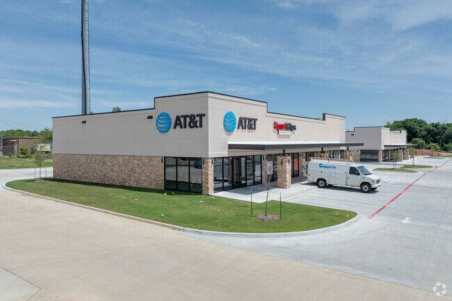
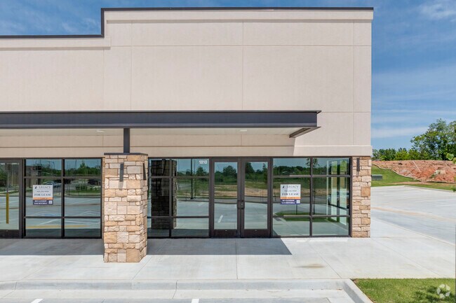
Property Record
2201 W Norfolk Dr W, Broken Arrow, OK 74011
NEARBY LISTINGS FOR SALE OR LEASE
Property Detail
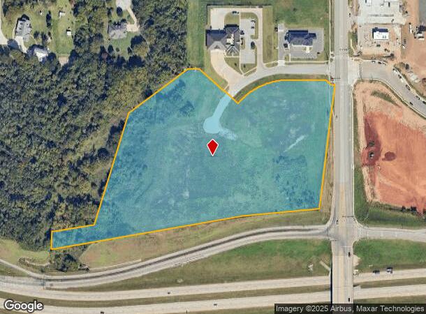
2201 W Norfolk Dr W
Tulsa, OK
Unplatted
98433-84-33-61570
PRT NE SE BEG 2574.83N & 42.72W SECR SE TH W17.29 NW35.32 W166.32 CRV LF 263.77 NW234.77 SW48.45 SW337.17 SW528.32 SW178.59 W8.61 S80.07 E13.89 NE860.65 NE350.14 NE564.41 POB SEC 33 18 14 14.157 ACS
Commercialacreage
Tulsa
X
Oklahoma
40143C0452M
14.16 AC
2025
Southeast
2025
Tulsa
007531
DEMOGRAPHICS near 2201 W Norfolk Dr W
1 Mile
3 Mile
5 Mile
2024 Total Population
4,854
50,570
118,317
2029 Population
5,042
52,149
122,775
Pop Growth 2024-2029
+ 3.87%
+ 3.12%
+ 3.77%
Average Age
39
39
39
2024 Total Households
1,927
18,850
44,599
HH Growth 2024-2029
+ 3.74%
+ 3.16%
+ 3.76%
Median Household Inc
$76,736
$84,048
$81,444
Avg Household Size
2.50
2.60
2.60
2024 Avg HH Vehicles
2.00
2.00
2.00
Median Home Value
$198,314
$213,166
$226,022
Median Year Built
1990
1987
1990
Nearby Places
Map Layers
Map Styles
 Street
 Aerial
- Restaurants
- Banks
- Shops
- Fitness
- Groceries
PUBLIC TRANSPORTATION
AIRPORT
Tulsa International
DRIVE
WALK
Distance
Tulsa International
28 min
20.0 mi
Freight Ports
Tulsa Port of Inola
DRIVE
WALK
Distance
Tulsa Port of Inola
37 min
31.1 mi
SALE & LEASE HISTORY
LISTING DATE
SALE/LEASE

Oct 13, 2023
For Lease
Nearby Properties
Address
Land Use
TOTAL SIZE
Lot Size
Zoning
Address
Land Use
TOTAL SIZE
Lot Size
Zoning
390,154 SF
52.94 AC
A1
Address
Land Use
TOTAL SIZE
Lot Size
Zoning
134,232 SF
28.52 AC
R2
Address
Land Use
TOTAL SIZE
Lot Size
Zoning
90,533 SF
29.41 AC
A1
Address
Land Use
TOTAL SIZE
Lot Size
Zoning
152,422 SF
44.60 AC
AG
Address
Land Use
TOTAL SIZE
Lot Size
Zoning
37.23 AC
A1
Address
Land Use
TOTAL SIZE
Lot Size
Zoning
21,301 SF
3.94 AC
CN
Address
Land Use
TOTAL SIZE
Lot Size
Zoning
84,314 SF
12.05 AC
A1
Address
Land Use
TOTAL SIZE
Lot Size
Zoning
68,478 SF
9.27 AC
R1
Address
Land Use
TOTAL SIZE
Lot Size
Zoning
35,954 SF
27.97 AC
CN
Address
Land Use
TOTAL SIZE
Lot Size
Zoning
67,490 SF
5.40 AC
RM
Address
Land Use
TOTAL SIZE
Lot Size
Zoning
Address
Land Use
TOTAL SIZE
Lot Size
Zoning
39,733 SF
9.36 AC
A1
Address
Land Use
TOTAL SIZE
Lot Size
Zoning
330,744 SF
17.43 AC
RM3
Address
Land Use
TOTAL SIZE
Lot Size
Zoning
55,185 SF
4.83 AC
NCU
Address
Land Use
TOTAL SIZE
Lot Size
Zoning
71,143 SF
4.43 AC
R1
Address
Land Use
TOTAL SIZE
Lot Size
Zoning
245,436 SF
12.21 AC
RM
Address
Land Use
TOTAL SIZE
Lot Size
Zoning
33,669 SF
4.64 AC
A1
Address
Land Use
TOTAL SIZE
Lot Size
Zoning
28,994 SF
8.96 AC
CG
Address
Land Use
TOTAL SIZE
Lot Size
Zoning
28,303 SF
16.76 AC
CN
Address
Land Use
TOTAL SIZE
Lot Size
Zoning
3,300 SF
40 AC
A1
Address
Land Use
TOTAL SIZE
Lot Size
Zoning
222,536 SF
11.31 AC
CN
Address
Land Use
TOTAL SIZE
Lot Size
Zoning
28,226 SF
8.26 AC
CN
Address
Land Use
TOTAL SIZE
Lot Size
Zoning
136,434 SF
19.20 AC
Address
Land Use
TOTAL SIZE
Lot Size
Zoning
30,482 SF
4.43 AC
R1
Address
Land Use
TOTAL SIZE
Lot Size
Zoning
27,531 SF
4.46 AC
R2
Address
Land Use
TOTAL SIZE
Lot Size
Zoning
11,261 SF
2.85 AC
CN
Address
Land Use
TOTAL SIZE
Lot Size
Zoning
Address
Land Use
TOTAL SIZE
Lot Size
Zoning
279,632 SF
14.54 AC
RM
Address
Land Use
TOTAL SIZE
Lot Size
Zoning
33,181 SF
4.54 AC
R1
Address
Land Use
TOTAL SIZE
Lot Size
Zoning
20,080 SF
9.60 AC
R1
The World's #1 Commercial Real Estate Marketplace
Connect with us
© 2026 CoStar Group
The information above has been obtained from sources believed reliable. While we do not doubt its accuracy we have not verified it and make no guarantee, warranty or representation about it. It is your responsibility to independently confirm its accuracy and completeness. Any projections, opinions, assumptions, or estimates used are for example only and do not represent the current or future performance of the property. The value of this transaction to you depends on tax and other factors which should be evaluated by your tax, financial, and legal advisors. You and your advisors should conduct a careful, independent investigation of the property to determine to your satisfaction the suitability of the property for your needs.