Property Record
2201 E White Mountain Blvd, Pinetop, AZ 85935
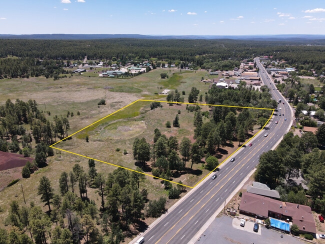
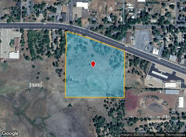
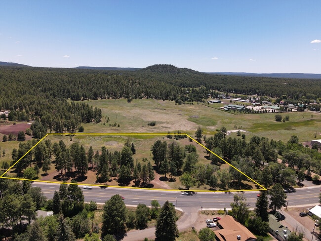

This Property Is For Sale
NEARBY LISTINGS FOR SALE OR LEASE
-
-
View all Pinetop listings for sale on LoopNet.com
Property Detail
2201 E White Mountain Blvd
311-44-026
SECTION 5,T8N,R23E:BEG NE COR SECTION 5; TH W 676.5;TH S TO SLY R/W HWY, TPOB; TH S 690;TH E 626.5TO PT 50 W OF SEC LINE; TH N 485 M/L TO SLY R/W HWY;TH NWLY ALG R/W 653M/L TPOB... LESS .02 ACRES PER 96-15157
Commercialacreage
Navajo
X
Arizona
04017C4956F
7.98 AC
2024
Arizona Northeast & Holbrook Area
2026
Other Market Areas
964901
Show Low, AZ
DEMOGRAPHICS near 2201 E White Mountain Blvd
1 Mile
3 Mile
5 Mile
2024 Total Population
1,807
10,117
14,425
2029 Population
1,980
10,987
15,579
Pop Growth 2024-2029
+ 9.57%
+ 8.60%
+ 8.00%
Average Age
44
44
45
2024 Total Households
734
3,977
5,778
HH Growth 2024-2029
+ 9.13%
+ 9.00%
+ 8.15%
Median Household Inc
$50,286
$63,490
$58,766
Avg Household Size
2.50
2.50
2.40
2024 Avg HH Vehicles
2.00
2.00
2.00
Median Home Value
$303,571
$243,117
$220,663
Median Year Built
1986
1989
1988
Nearby Places
- Restaurants
- Banks
- Shops
- Fitness
- Groceries
Nearby Properties
Address
Land Use
TOTAL SIZE
Lot Size
Zoning
Address
Land Use
TOTAL SIZE
Lot Size
Zoning
320 AC
Address
Land Use
TOTAL SIZE
Lot Size
Zoning
99,979 SF
10.70 AC
MUNICIPAL
Address
Land Use
TOTAL SIZE
Lot Size
Zoning
38,549 SF
2.40 AC
MUNICIPAL
Address
Land Use
TOTAL SIZE
Lot Size
Zoning
18,694 SF
19.77 AC
SD
Address
Land Use
TOTAL SIZE
Lot Size
Zoning
68,009 SF
5.41 AC
C-R
Address
Land Use
TOTAL SIZE
Lot Size
Zoning
20,555 SF
19.27 AC
MUNICIPAL
Address
Land Use
TOTAL SIZE
Lot Size
Zoning
21,761 SF
0.92 AC
MUNICIPAL
Address
Land Use
TOTAL SIZE
Lot Size
Zoning
39,350 SF
4.24 AC
MUNICIPAL
Address
Land Use
TOTAL SIZE
Lot Size
Zoning
22,389 SF
3.16 AC
MUNICIPAL
Address
Land Use
TOTAL SIZE
Lot Size
Zoning
107.88 AC
Address
Land Use
TOTAL SIZE
Lot Size
Zoning
21,538 SF
1.30 AC
MUNICIPAL
Address
Land Use
TOTAL SIZE
Lot Size
Zoning
9,514 SF
2.40 AC
MUNICIPAL
Address
Land Use
TOTAL SIZE
Lot Size
Zoning
16,458 SF
3.20 AC
MUNICIPAL
Address
Land Use
TOTAL SIZE
Lot Size
Zoning
17,843 SF
0.92 AC
MUNICIPAL
Address
Land Use
TOTAL SIZE
Lot Size
Zoning
30,166 SF
1.56 AC
MUNICIPAL
Address
Land Use
TOTAL SIZE
Lot Size
Zoning
12,343 SF
3.61 AC
MUNICIPAL
Address
Land Use
TOTAL SIZE
Lot Size
Zoning
28,050 SF
2.38 AC
MUNICIPAL
Address
Land Use
TOTAL SIZE
Lot Size
Zoning
14,770 SF
1.30 AC
MUNICIPAL
Address
Land Use
TOTAL SIZE
Lot Size
Zoning
28,195 SF
6.62 AC
R1-10
Address
Land Use
TOTAL SIZE
Lot Size
Zoning
12,387 SF
1.47 AC
MUNICIPAL
Address
Land Use
TOTAL SIZE
Lot Size
Zoning
12,042 SF
0.92 AC
MUNICIPAL
Address
Land Use
TOTAL SIZE
Lot Size
Zoning
320 SF
50 AC
MUNICIPAL
Address
Land Use
TOTAL SIZE
Lot Size
Zoning
9,644 SF
0.92 AC
MUNICIPAL
Address
Land Use
TOTAL SIZE
Lot Size
Zoning
17,392 SF
1.18 AC
MUNICIPAL
Address
Land Use
TOTAL SIZE
Lot Size
Zoning
9,078 SF
2.56 AC
MUNICIPAL
Address
Land Use
TOTAL SIZE
Lot Size
Zoning
10,426 SF
0.80 AC
MUNICIPAL
Address
Land Use
TOTAL SIZE
Lot Size
Zoning
12,464 SF
0.99 AC
MUNICIPAL
Address
Land Use
TOTAL SIZE
Lot Size
Zoning
11,152 SF
1 AC
SD
Address
Land Use
TOTAL SIZE
Lot Size
Zoning
15,703 SF
1.07 AC
MUNICIPAL
The World's #1 Commercial Real Estate Marketplace
Connect with us
© 2025 CoStar Group
The information above has been obtained from sources believed reliable. While we do not doubt its accuracy we have not verified it and make no guarantee, warranty or representation about it. It is your responsibility to independently confirm its accuracy and completeness. Any projections, opinions, assumptions, or estimates used are for example only and do not represent the current or future performance of the property. The value of this transaction to you depends on tax and other factors which should be evaluated by your tax, financial, and legal advisors. You and your advisors should conduct a careful, independent investigation of the property to determine to your satisfaction the suitability of the property for your needs.