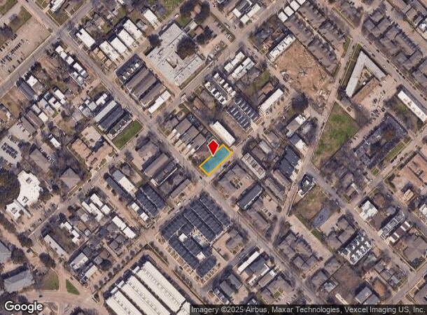
Property Record
2202 N Carroll Ave, Dallas, TX 75204
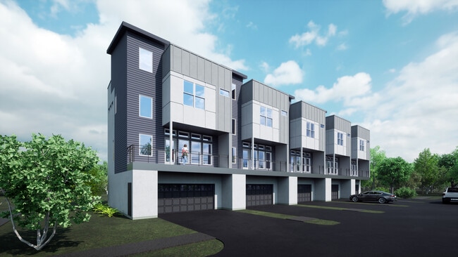
This Property Is For Sale
NEARBY LISTINGS FOR SALE OR LEASE
Property Detail
2202 N Carroll Ave
Dallas-Fort Worth-Arlington, TX
Elk Hill
00000161818000000
Dallas
Townhouserowhouse
Texas
X
0.20 AC
48113C0345J
Knox Henderson
1,070 SF
Dallas/Ft Worth
DEMOGRAPHICS near 2202 N Carroll Ave
1 Mile
3 Mile
5 Mile
2024 Total Population
42,599
216,782
411,333
2029 Population
43,447
219,607
415,151
Pop Growth 2024-2029
+ 1.99%
+ 1.30%
+ 0.93%
Average Age
34
37
37
2024 Total Households
25,131
114,422
196,977
HH Growth 2024-2029
+ 1.81%
+ 1.43%
+ 1.00%
Median Household Inc
$75,126
$82,936
$71,893
Avg Household Size
1.70
1.80
2.00
2024 Avg HH Vehicles
1.00
1.00
1.00
Median Home Value
$431,899
$496,569
$470,990
Median Year Built
2003
1998
1990
Nearby Places
Map Layers
Map Styles
 Street
 Aerial
- Restaurants
- Banks
- Shops
- Fitness
- Groceries
PUBLIC TRANSPORTATION
TRANSIT/SUBWAY
Cityplace/Uptown (Blue Line - Dallas Area Rapid Transit (DART), Orange Line - Dallas Area Rapid Transit (DART), Red Line - Dallas Area Rapid Transit (DART))
DRIVE
WALK
Distance
Cityplace/Uptown (Blue Line - Dallas Area Rapid Transit (DART), Orange Line - Dallas Area Rapid Transit (DART), Red Line - Dallas Area Rapid Transit (DART))
5 min
15 min
0.8 mi
Cityplace (McKinney Avenue) (McKinney Avenue Streetcar - Dallas Area Rapid Transit (DART))
DRIVE
WALK
Distance
Cityplace (McKinney Avenue) (McKinney Avenue Streetcar - Dallas Area Rapid Transit (DART))
3 min
17 min
0.9 mi
McKinney and Blackburn (McKinney Avenue Streetcar - Dallas Area Rapid Transit (DART))
DRIVE
WALK
Distance
McKinney and Blackburn (McKinney Avenue Streetcar - Dallas Area Rapid Transit (DART))
3 min
18 min
0.9 mi
Cole And Blackburn (McKinney Avenue Streetcar - Dallas Area Rapid Transit (DART))
DRIVE
WALK
Distance
Cole And Blackburn (McKinney Avenue Streetcar - Dallas Area Rapid Transit (DART))
3 min
20 min
1.0 mi
McKinney and Lemmon West (McKinney Avenue Streetcar - Dallas Area Rapid Transit (DART))
DRIVE
WALK
Distance
McKinney and Lemmon West (McKinney Avenue Streetcar - Dallas Area Rapid Transit (DART))
3 min
20 min
1.0 mi
COMMUTER RAIL
DRIVE
WALK
Distance
6 min
3.0 mi
DRIVE
WALK
Distance
9 min
4.2 mi
AIRPORT
Dallas Love Field
DRIVE
WALK
Distance
Dallas Love Field
13 min
5.4 mi
Dallas-Fort Worth International
DRIVE
WALK
Distance
Dallas-Fort Worth International
30 min
21.2 mi
Nearby Properties
Address
Land Use
TOTAL SIZE
Lot Size
Zoning
Address
Land Use
TOTAL SIZE
Lot Size
Zoning
2,658,374 SF
37.70 AC
Z116
Address
Land Use
TOTAL SIZE
Lot Size
Zoning
1,634,356 SF
92.90 AC
Z421
Address
Land Use
TOTAL SIZE
Lot Size
Zoning
3,713,071 SF
9.94 AC
Address
Land Use
TOTAL SIZE
Lot Size
Zoning
815,000 SF
7.20 AC
Z239
Address
Land Use
TOTAL SIZE
Lot Size
Zoning
1,676,176 SF
2.18 AC
Z239
Address
Land Use
TOTAL SIZE
Lot Size
Zoning
906,730 SF
3.09 AC
Z239
Address
Land Use
TOTAL SIZE
Lot Size
Zoning
858,872 SF
23.90 AC
Z421
Address
Land Use
TOTAL SIZE
Lot Size
Zoning
1,003,498 SF
22.15 AC
Z116
Address
Land Use
TOTAL SIZE
Lot Size
Zoning
1,308,710 SF
8.42 AC
Z21
Address
Land Use
TOTAL SIZE
Lot Size
Zoning
299,170 SF
9.71 AC
Z97
Address
Land Use
TOTAL SIZE
Lot Size
Zoning
731,849 SF
3.13 AC
Z239
Address
Land Use
TOTAL SIZE
Lot Size
Zoning
1,896,570 SF
18.08 AC
Z151
Address
Land Use
TOTAL SIZE
Lot Size
Zoning
1,480,246 SF
1.86 AC
Z21
Address
Land Use
TOTAL SIZE
Lot Size
Zoning
1,291,660 SF
2.56 AC
Z248
Address
Land Use
TOTAL SIZE
Lot Size
Zoning
1,026,046 SF
2.89 AC
Z248
Address
Land Use
TOTAL SIZE
Lot Size
Zoning
864,909 SF
3.02 AC
Z248
Address
Land Use
TOTAL SIZE
Lot Size
Zoning
1,001,504 SF
3.37 AC
Z151
Address
Land Use
TOTAL SIZE
Lot Size
Zoning
1,424,070 SF
1.36 AC
Z21
Address
Land Use
TOTAL SIZE
Lot Size
Zoning
724,979 SF
1.05 AC
Z239
Address
Land Use
TOTAL SIZE
Lot Size
Zoning
893,159 SF
1.17 AC
Z21
Address
Land Use
TOTAL SIZE
Lot Size
Zoning
100 SF
27.05 AC
Z421
Address
Land Use
TOTAL SIZE
Lot Size
Zoning
1,980,000 SF
2.57 AC
Z21
Address
Land Use
TOTAL SIZE
Lot Size
Zoning
857,292 SF
1.47 AC
Z239
Address
Land Use
TOTAL SIZE
Lot Size
Zoning
602,716 SF
11.21 AC
Z239
Address
Land Use
TOTAL SIZE
Lot Size
Zoning
763,198 SF
3.01 AC
Z248
Address
Land Use
TOTAL SIZE
Lot Size
Zoning
638,046 SF
2.11 AC
Z239
Address
Land Use
TOTAL SIZE
Lot Size
Zoning
486,300 SF
1.55 AC
Z239
Address
Land Use
TOTAL SIZE
Lot Size
Zoning
906,627 SF
3.83 AC
Z239
Address
Land Use
TOTAL SIZE
Lot Size
Zoning
226,331 SF
1.12 AC
Address
Land Use
TOTAL SIZE
Lot Size
Zoning
653,557 SF
0.68 AC
Z248
The World's #1 Commercial Real Estate Marketplace
Connect with us
© 2026 CoStar Group
The information above has been obtained from sources believed reliable. While we do not doubt its accuracy we have not verified it and make no guarantee, warranty or representation about it. It is your responsibility to independently confirm its accuracy and completeness. Any projections, opinions, assumptions, or estimates used are for example only and do not represent the current or future performance of the property. The value of this transaction to you depends on tax and other factors which should be evaluated by your tax, financial, and legal advisors. You and your advisors should conduct a careful, independent investigation of the property to determine to your satisfaction the suitability of the property for your needs.