Property Record
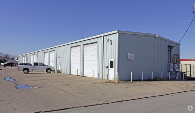
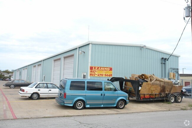
2202 Raper Blvd, Pantego, TX 76013

Property Detail
2202 Raper Blvd
Dallas-Fort Worth-Arlington, TX
LANES INDUSTRIAL PARK ADDITION LOT 17R1
06717187
Tarrant
Commercialnec
Texas
B and X Area of moderate flood hazard, usually the area between the limits of the 100-year and 500-year floods.
17
2024
1.13 AC
2025
Arlington
111506
Dallas/Ft Worth
21,550 SF
NEARBY LISTINGS FOR SALE OR LEASE
DEMOGRAPHICS near 2202 Raper Blvd
1 mile
3 mile
5 mile
2025 Total Population
11,481
94,639
301,830
2030 Population
11,999
99,022
317,199
Pop Growth 2025-2030
+ 4.51%
+ 4.63%
+ 5.09%
Average Age
42
40
38
2025 Total Households
4,782
36,372
111,249
HH Growth 2025-2030
+ 4.62%
+ 4.78%
+ 5.27%
Median Household Inc
$70,586
$78,879
$70,254
Avg Household Size
2.40
2.50
2.60
2025 Avg HH Vehicles
2.00
2.00
2.00
Median Home Value
$363,743
$328,281
$298,106
Median Year Built
1977
1979
1981
Nearby Places
Map Layers
Map Styles
 Street
 Aerial
Transit
 Traffic
 Biking
Places
Listings with unknown addresses are not visible on the map
- Restaurants
- Banks
- Shops
- Fitness
- Groceries
PUBLIC TRANSPORTATION
COMMUTER RAIL
Bell Station (TRINITY RAILWAY - Dallas Area Rapid Transit (DART))
Drive
Walk
Distance
Bell Station (TRINITY RAILWAY - Dallas Area Rapid Transit (DART))
20 min
9.9 mi
AIRPORT
Dallas-Fort Worth International
Drive
Walk
Distance
Dallas-Fort Worth International
32 min
21.1 mi
Dallas Love Field
Drive
Walk
Distance
Dallas Love Field
43 min
29.8 mi
Freight Ports
Port of Shreveport
Drive
Walk
Distance
Port of Shreveport
238 min
220.2 mi
Nearby Properties
Address
Land Use
TOTAL SIZE
Lot Size
Zoning
Address
Land Use
TOTAL SIZE
Lot Size
Zoning
537,189 SF
29.08 AC
Address
Land Use
TOTAL SIZE
Lot Size
Zoning
569,312 SF
71.52 AC
Address
Land Use
TOTAL SIZE
Lot Size
Zoning
492,837 SF
4.99 AC
Address
Land Use
TOTAL SIZE
Lot Size
Zoning
462,396 SF
25.76 AC
Address
Land Use
TOTAL SIZE
Lot Size
Zoning
296,092 SF
7.66 AC
Address
Land Use
TOTAL SIZE
Lot Size
Zoning
386,575 SF
42.27 AC
Address
Land Use
TOTAL SIZE
Lot Size
Zoning
257,077 SF
14.49 AC
Address
Land Use
TOTAL SIZE
Lot Size
Zoning
242,811 SF
13.60 AC
Address
Land Use
TOTAL SIZE
Lot Size
Zoning
268,643 SF
12.50 AC
Address
Land Use
TOTAL SIZE
Lot Size
Zoning
218,110 SF
8.85 AC
Address
Land Use
TOTAL SIZE
Lot Size
Zoning
213,824 SF
11.66 AC
Address
Land Use
TOTAL SIZE
Lot Size
Zoning
168,193 SF
10.06 AC
Address
Land Use
TOTAL SIZE
Lot Size
Zoning
204,094 SF
16.99 AC
Address
Land Use
TOTAL SIZE
Lot Size
Zoning
190,755 SF
33.09 AC
Address
Land Use
TOTAL SIZE
Lot Size
Zoning
193,909 SF
21.83 AC
Address
Land Use
TOTAL SIZE
Lot Size
Zoning
206,149 SF
10.12 AC
Address
Land Use
TOTAL SIZE
Lot Size
Zoning
144,164 SF
9.31 AC
Address
Land Use
TOTAL SIZE
Lot Size
Zoning
189,675 SF
8.78 AC
Address
Land Use
TOTAL SIZE
Lot Size
Zoning
117,293 SF
6.98 AC
Address
Land Use
TOTAL SIZE
Lot Size
Zoning
166,088 SF
12.98 AC
Address
Land Use
TOTAL SIZE
Lot Size
Zoning
112,000 SF
16.59 AC
Address
Land Use
TOTAL SIZE
Lot Size
Zoning
127,090 SF
11.16 AC
Address
Land Use
TOTAL SIZE
Lot Size
Zoning
92,377 SF
3.23 AC
Address
Land Use
TOTAL SIZE
Lot Size
Zoning
101,320 SF
5.59 AC
Address
Land Use
TOTAL SIZE
Lot Size
Zoning
4,825 SF
30.22 AC
Address
Land Use
TOTAL SIZE
Lot Size
Zoning
85,001 SF
29.35 AC
Address
Land Use
TOTAL SIZE
Lot Size
Zoning
208,062 SF
4.49 AC
Address
Land Use
TOTAL SIZE
Lot Size
Zoning
110,684 SF
7 AC
Address
Land Use
TOTAL SIZE
Lot Size
Zoning
93,960 SF
9.28 AC
Address
Land Use
TOTAL SIZE
Lot Size
Zoning
63,676 SF
32.23 AC
The World's #1 Commercial Real Estate Marketplace
Connect with us
© 2026 CoStar Group
The information above has been obtained from sources believed reliable. While we do not doubt its accuracy we have not verified it and make no guarantee, warranty or representation about it. It is your responsibility to independently confirm its accuracy and completeness. Any projections, opinions, assumptions, or estimates used are for example only and do not represent the current or future performance of the property. The value of this transaction to you depends on tax and other factors which should be evaluated by your tax, financial, and legal advisors. You and your advisors should conduct a careful, independent investigation of the property to determine to your satisfaction the suitability of the property for your needs.