Property Record
2202 Roseanne Ct, Fairborn, OH 45324

NEARBY LISTINGS FOR SALE OR LEASE
-
-
View all Fairborn listings for sale on LoopNet.com
Property Detail
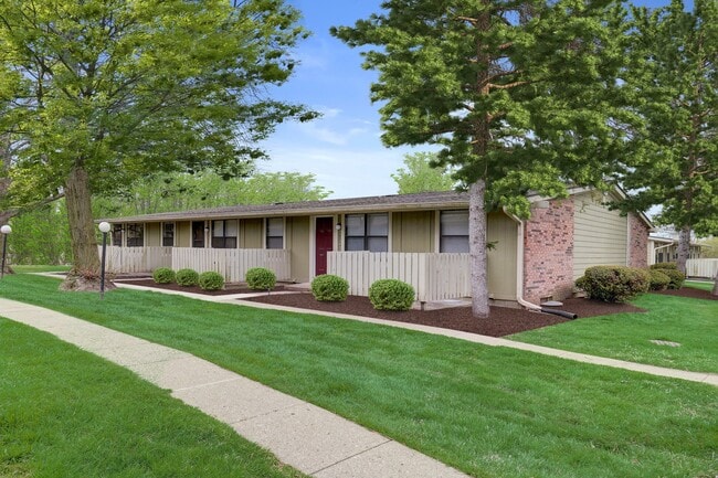
2202 Roseanne Ct
Dayton, OH
Red Deer Apartments
A02-0002-0029-0-0043-00
RED DEER APARTMENTS SEC II LOT 6631 5.669A
Apartment
Greene
X
Ohio
39057C0019E
6631
2024
5.67 AC
2024
Fairborn/AFB
200901
Cincinnati/Dayton
9,216 SF
DEMOGRAPHICS near 2202 Roseanne Ct
1 Mile
3 Mile
5 Mile
2024 Total Population
7,309
35,597
76,311
2029 Population
7,584
36,604
78,614
Pop Growth 2024-2029
+ 3.76%
+ 2.83%
+ 3.02%
Average Age
41
39
39
2024 Total Households
3,252
15,572
32,050
HH Growth 2024-2029
+ 3.94%
+ 2.81%
+ 3.15%
Median Household Inc
$91,275
$69,589
$76,368
Avg Household Size
2.20
2.20
2.30
2024 Avg HH Vehicles
2.00
2.00
2.00
Median Home Value
$215,467
$183,823
$205,852
Median Year Built
1993
1977
1978
Nearby Places
Map Layers
Map Styles
 Street
 Aerial
- Restaurants
- Banks
- Shops
- Fitness
- Groceries
PUBLIC TRANSPORTATION
AIRPORT
James M Cox Dayton International
DRIVE
WALK
Distance
James M Cox Dayton International
31 min
22.1 mi
Freight Ports
Port of Toledo
DRIVE
WALK
Distance
Port of Toledo
190 min
162.3 mi
Nearby Properties
Address
Land Use
TOTAL SIZE
Lot Size
Zoning
Address
Land Use
TOTAL SIZE
Lot Size
Zoning
552,803 SF
29.77 AC
CPUD882
Address
Land Use
TOTAL SIZE
Lot Size
Zoning
7,087 SF
31.93 AC
MX-PUD 93-
Address
Land Use
TOTAL SIZE
Lot Size
Zoning
49,316 SF
30.39 AC
CPUD933
Address
Land Use
TOTAL SIZE
Lot Size
Zoning
101,768 SF
22.02 AC
B1
Address
Land Use
TOTAL SIZE
Lot Size
Zoning
47,424 SF
22.77 AC
RPUD917
Address
Land Use
TOTAL SIZE
Lot Size
Zoning
27,740 SF
11.16 AC
MXPUD93
Address
Land Use
TOTAL SIZE
Lot Size
Zoning
32,852 SF
18.80 AC
C-PUD 94-4
Address
Land Use
TOTAL SIZE
Lot Size
Zoning
45,522 SF
10.22 AC
Address
Land Use
TOTAL SIZE
Lot Size
Zoning
3,038 SF
13.49 AC
RPUD936
Address
Land Use
TOTAL SIZE
Lot Size
Zoning
121,392 SF
12.47 AC
Address
Land Use
TOTAL SIZE
Lot Size
Zoning
57,816 SF
9.15 AC
PD1
Address
Land Use
TOTAL SIZE
Lot Size
Zoning
143,457 SF
19.42 AC
CPUD918
Address
Land Use
TOTAL SIZE
Lot Size
Zoning
594,070 SF
43.95 AC
AG
Address
Land Use
TOTAL SIZE
Lot Size
Zoning
45,204 SF
14.92 AC
PD1
Address
Land Use
TOTAL SIZE
Lot Size
Zoning
75,168 SF
2.73 AC
Address
Land Use
TOTAL SIZE
Lot Size
Zoning
81,978 SF
3.64 AC
CPUD055
Address
Land Use
TOTAL SIZE
Lot Size
Zoning
1,630 SF
8.41 AC
MXPUD93
Address
Land Use
TOTAL SIZE
Lot Size
Zoning
163,780 SF
36.93 AC
PARK
Address
Land Use
TOTAL SIZE
Lot Size
Zoning
278,290 SF
18.87 AC
AG
Address
Land Use
TOTAL SIZE
Lot Size
Zoning
7,040 SF
55.41 AC
R2
Address
Land Use
TOTAL SIZE
Lot Size
Zoning
121,790 SF
14.50 AC
MXPUD93
Address
Land Use
TOTAL SIZE
Lot Size
Zoning
7,772 SF
8.52 AC
R3
Address
Land Use
TOTAL SIZE
Lot Size
Zoning
61,314 SF
3.25 AC
PD2
Address
Land Use
TOTAL SIZE
Lot Size
Zoning
53,267 SF
2.23 AC
Address
Land Use
TOTAL SIZE
Lot Size
Zoning
14,496 SF
0.64 AC
2
Address
Land Use
TOTAL SIZE
Lot Size
Zoning
46,656 SF
10.35 AC
PD1
Address
Land Use
TOTAL SIZE
Lot Size
Zoning
76,174 SF
2.04 AC
Address
Land Use
TOTAL SIZE
Lot Size
Zoning
76,912 SF
3.08 AC
PD2
Address
Land Use
TOTAL SIZE
Lot Size
Zoning
58,897 SF
4.71 AC
CPUD923
Address
Land Use
TOTAL SIZE
Lot Size
Zoning
100,197 SF
9.38 AC
MX-PUD 93-
The World's #1 Commercial Real Estate Marketplace
Connect with us
© 2026 CoStar Group
The information above has been obtained from sources believed reliable. While we do not doubt its accuracy we have not verified it and make no guarantee, warranty or representation about it. It is your responsibility to independently confirm its accuracy and completeness. Any projections, opinions, assumptions, or estimates used are for example only and do not represent the current or future performance of the property. The value of this transaction to you depends on tax and other factors which should be evaluated by your tax, financial, and legal advisors. You and your advisors should conduct a careful, independent investigation of the property to determine to your satisfaction the suitability of the property for your needs.