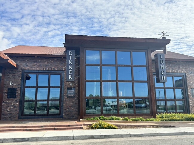
Property Record
22020 Us Highway 18, Apple Valley, CA 92307

NEARBY LISTINGS FOR SALE OR LEASE
Property Detail
22020 Us Highway 18
Riverside-San Bernardino-Ontario, CA
Tract No. 3032
3112-653-10
TRACT 3032 LOT 525 TR NO 3032 APPLE VALLEY RO UNIT NO 3 LOT 525 EX UND 1/2 INT MIN RTS WOSE
Restaurantbuilding
San Bernardino
D
California
06071C5845H
525
2024
0.52 AC
2025
Mojave River Valley
009713
Inland Empire (California)
9,545 SF
DEMOGRAPHICS near 22020 Us Highway 18
1 Mile
3 Mile
5 Mile
2024 Total Population
6,149
39,292
82,222
2029 Population
6,198
39,931
84,153
Pop Growth 2024-2029
+ 0.80%
+ 1.63%
+ 2.35%
Average Age
36
37
39
2024 Total Households
1,978
12,514
28,113
HH Growth 2024-2029
+ 0.81%
+ 1.61%
+ 2.38%
Median Household Inc
$43,596
$62,657
$72,374
Avg Household Size
3.10
3.10
2.90
2024 Avg HH Vehicles
2.00
2.00
2.00
Median Home Value
$252,631
$324,653
$373,326
Median Year Built
1982
1984
1986
Nearby Places
Map Layers
Map Styles
 Street
 Aerial
- Restaurants
- Banks
- Shops
- Fitness
- Groceries
SALE & LEASE HISTORY
LISTING DATE
SALE/LEASE

Dec 02, 2024
For Lease
Dec 02, 2024
For Sale
Nearby Properties
Address
Land Use
TOTAL SIZE
Lot Size
Zoning
Address
Land Use
TOTAL SIZE
Lot Size
Zoning
116,365 SF
8.93 AC
Address
Land Use
TOTAL SIZE
Lot Size
Zoning
172,153 SF
13.13 AC
Address
Land Use
TOTAL SIZE
Lot Size
Zoning
103,804 SF
14.32 AC
Address
Land Use
TOTAL SIZE
Lot Size
Zoning
57,365 SF
5.61 AC
Address
Land Use
TOTAL SIZE
Lot Size
Zoning
18,800 SF
2.60 AC
Address
Land Use
TOTAL SIZE
Lot Size
Zoning
75,280 SF
4.07 AC
Address
Land Use
TOTAL SIZE
Lot Size
Zoning
Address
Land Use
TOTAL SIZE
Lot Size
Zoning
29,042 SF
2.62 AC
Address
Land Use
TOTAL SIZE
Lot Size
Zoning
14,739 SF
1.38 AC
Address
Land Use
TOTAL SIZE
Lot Size
Zoning
16,804 SF
1.80 AC
Address
Land Use
TOTAL SIZE
Lot Size
Zoning
5,394 SF
1.88 AC
Address
Land Use
TOTAL SIZE
Lot Size
Zoning
35,178 SF
3.44 AC
Address
Land Use
TOTAL SIZE
Lot Size
Zoning
39,741 SF
3.68 AC
Address
Land Use
TOTAL SIZE
Lot Size
Zoning
22,488 SF
3.05 AC
Address
Land Use
TOTAL SIZE
Lot Size
Zoning
86,148 SF
5.38 AC
Address
Land Use
TOTAL SIZE
Lot Size
Zoning
14,235 SF
1.15 AC
Address
Land Use
TOTAL SIZE
Lot Size
Zoning
4,998 SF
2.76 AC
Address
Land Use
TOTAL SIZE
Lot Size
Zoning
2,618 SF
6.77 AC
Address
Land Use
TOTAL SIZE
Lot Size
Zoning
27,661 SF
2.36 AC
Address
Land Use
TOTAL SIZE
Lot Size
Zoning
138,827 SF
12.53 AC
Address
Land Use
TOTAL SIZE
Lot Size
Zoning
14,989 SF
1.42 AC
Address
Land Use
TOTAL SIZE
Lot Size
Zoning
55,415 SF
2.91 AC
Address
Land Use
TOTAL SIZE
Lot Size
Zoning
53,972 SF
4.80 AC
Address
Land Use
TOTAL SIZE
Lot Size
Zoning
3,500 SF
0.51 AC
Address
Land Use
TOTAL SIZE
Lot Size
Zoning
64,784 SF
28.73 AC
Address
Land Use
TOTAL SIZE
Lot Size
Zoning
22,700 SF
6.19 AC
Address
Land Use
TOTAL SIZE
Lot Size
Zoning
60.38 AC
Address
Land Use
TOTAL SIZE
Lot Size
Zoning
37,521 SF
24.52 AC
Address
Land Use
TOTAL SIZE
Lot Size
Zoning
17,802 SF
1.95 AC
Address
Land Use
TOTAL SIZE
Lot Size
Zoning
The World's #1 Commercial Real Estate Marketplace
Connect with us
© 2025 CoStar Group
The information above has been obtained from sources believed reliable. While we do not doubt its accuracy we have not verified it and make no guarantee, warranty or representation about it. It is your responsibility to independently confirm its accuracy and completeness. Any projections, opinions, assumptions, or estimates used are for example only and do not represent the current or future performance of the property. The value of this transaction to you depends on tax and other factors which should be evaluated by your tax, financial, and legal advisors. You and your advisors should conduct a careful, independent investigation of the property to determine to your satisfaction the suitability of the property for your needs.