Property Record
2204 Manhattan St, , LA


Save to a Folder
{{folder.Name}}
{{folder.ListingIds.length}} Properties
{{folder.ListingIds.length}} Property
Create a New Folder
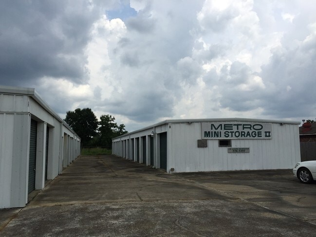
Property Detail
2204 Manhattan St
Baton Rouge, LA
WARD: 2-2, SUBDIVISION: BAKER COMMERCIAL PARK, LOT: B-4-1-A. TRACT B-4-1-A, RESUB OF TRACTS B-4-1, B-5-1 & B-5-2-A, BAKER COM
01303228
E BATON ROUGE
Storesoffices
Louisiana
AE The base floodplain where base flood elevations are provided. AE Zones are now used on new format FIRMs instead of A1-A30 Zones.
b-4-1-a
2025
1.04 AC
2025
East Baton Rouge Parish North
0042042003
Baton Rouge
NEARBY LISTINGS FOR SALE OR LEASE
DEMOGRAPHICS near 2204 Manhattan St
1 mile
3 mile
5 mile
2025 Total Population
3,946
18,916
48,729
2030 Population
3,928
18,857
48,687
Pop Growth 2025-2030
(0.46%)
(0.31%)
(0.09%)
Average Age
38
39
38
2025 Total Households
1,485
6,962
17,133
HH Growth 2025-2030
(0.61%)
(0.39%)
(0.11%)
Median Household Inc
$45,663
$50,223
$55,328
Avg Household Size
2.60
2.60
2.60
2025 Avg HH Vehicles
2.00
2.00
2.00
Median Home Value
$152,906
$158,047
$186,429
Median Year Built
1976
1980
1981
Nearby Places
Map Layers
Map Styles
 Street
 Aerial
Layers
 Traffic
 Biking
Places
Listings with unknown addresses are not visible on the map
- Restaurants
- Banks
- Shops
- Fitness
- Groceries
PUBLIC TRANSPORTATION
AIRPORT
Baton Rouge Metro Ryan Field
Drive
Walk
Distance
Baton Rouge Metro Ryan Field
12 min
7.1 mi
Freight Ports
Port of Greater Baton Rouge
Drive
Walk
Distance
Port of Greater Baton Rouge
26 min
15.8 mi
Nearby Properties
Address
Land Use
TOTAL SIZE
Lot Size
Zoning
Address
Land Use
TOTAL SIZE
Lot Size
Zoning
186,000 SF
23.51 AC
Address
Land Use
TOTAL SIZE
Lot Size
Zoning
34,310 SF
7.74 AC
Address
Land Use
TOTAL SIZE
Lot Size
Zoning
Address
Land Use
TOTAL SIZE
Lot Size
Zoning
87.06 AC
Address
Land Use
TOTAL SIZE
Lot Size
Zoning
36.32 AC
Address
Land Use
TOTAL SIZE
Lot Size
Zoning
72,300 SF
24.63 AC
Address
Land Use
TOTAL SIZE
Lot Size
Zoning
12.59 AC
Address
Land Use
TOTAL SIZE
Lot Size
Zoning
1.42 AC
Address
Land Use
TOTAL SIZE
Lot Size
Zoning
100,000 SF
7.48 AC
Address
Land Use
TOTAL SIZE
Lot Size
Zoning
Address
Land Use
TOTAL SIZE
Lot Size
Zoning
44,200 SF
6.53 AC
Address
Land Use
TOTAL SIZE
Lot Size
Zoning
36,750 SF
17.27 AC
Address
Land Use
TOTAL SIZE
Lot Size
Zoning
16,583 SF
5.61 AC
Address
Land Use
TOTAL SIZE
Lot Size
Zoning
8,500 SF
3.18 AC
Address
Land Use
TOTAL SIZE
Lot Size
Zoning
2.70 AC
Address
Land Use
TOTAL SIZE
Lot Size
Zoning
2.48 AC
Address
Land Use
TOTAL SIZE
Lot Size
Zoning
9,800 SF
3.60 AC
Address
Land Use
TOTAL SIZE
Lot Size
Zoning
Address
Land Use
TOTAL SIZE
Lot Size
Zoning
16,102 SF
1.26 AC
Address
Land Use
TOTAL SIZE
Lot Size
Zoning
6,489 SF
0.74 AC
Address
Land Use
TOTAL SIZE
Lot Size
Zoning
13,225 SF
1.34 AC
Address
Land Use
TOTAL SIZE
Lot Size
Zoning
85,850 SF
3.98 AC
Address
Land Use
TOTAL SIZE
Lot Size
Zoning
1.08 AC
Address
Land Use
TOTAL SIZE
Lot Size
Zoning
29,609 SF
17.39 AC
Address
Land Use
TOTAL SIZE
Lot Size
Zoning
4.77 AC
Address
Land Use
TOTAL SIZE
Lot Size
Zoning
32,250 SF
5 AC
Address
Land Use
TOTAL SIZE
Lot Size
Zoning
53,200 SF
5.41 AC
Address
Land Use
TOTAL SIZE
Lot Size
Zoning
41,375 SF
5 AC
Address
Land Use
TOTAL SIZE
Lot Size
Zoning
16,799 SF
1.53 AC
Address
Land Use
TOTAL SIZE
Lot Size
Zoning
14.03 AC
The World's #1 Commercial Real Estate Marketplace
Connect with us
© 2026 CoStar Group
The information above has been obtained from sources believed reliable. While we do not doubt its accuracy we have not verified it and make no guarantee, warranty or representation about it. It is your responsibility to independently confirm its accuracy and completeness. Any projections, opinions, assumptions, or estimates used are for example only and do not represent the current or future performance of the property. The value of this transaction to you depends on tax and other factors which should be evaluated by your tax, financial, and legal advisors. You and your advisors should conduct a careful, independent investigation of the property to determine to your satisfaction the suitability of the property for your needs.