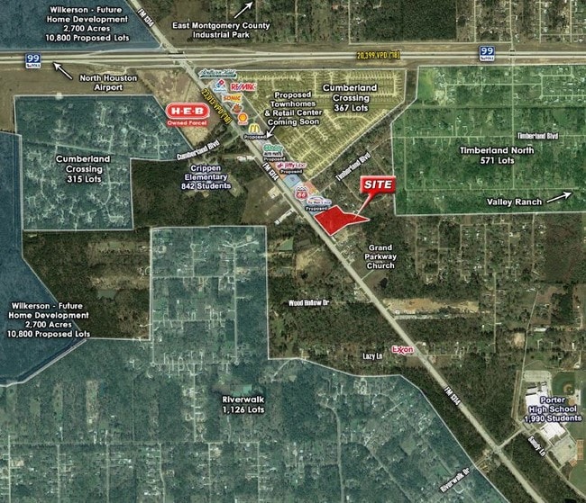
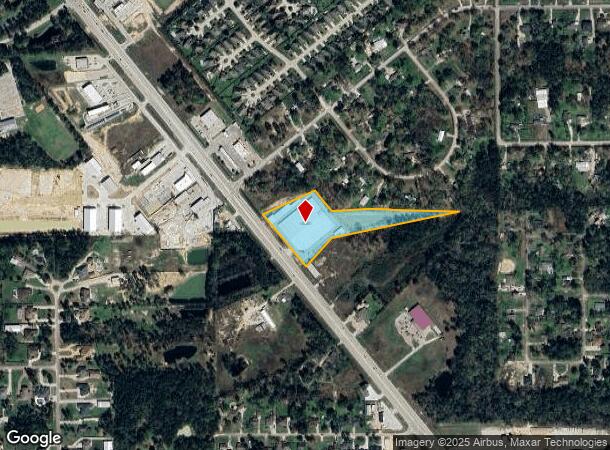
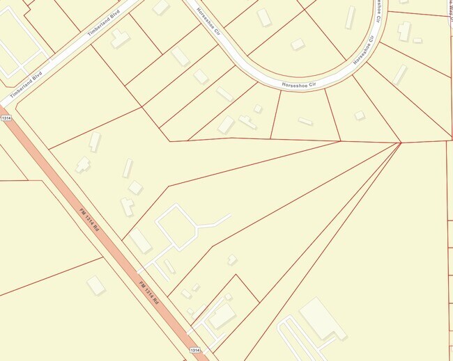
Property Record
22041 Fm 1314 Rd, Porter, TX 77365
NEARBY LISTINGS FOR SALE OR LEASE
Property Detail
22041 Fm 1314 Rd
0684-00-00200
Cole Praen
Commercialnec
A0684 - COLE PRAEN, TRACT 2 (3.7356 AC), SERIAL TXFLV12A54212CE11, LABEL # RAD1034804, S924900 - RES B-1(0.80 AC), ACRES 4.5356
X
Montgomery
48339C0575G
Texas
2024
4.54 AC
2025
Outlying Montgomery Cnty
692604
Houston
86,744 SF
Houston-Pasadena-The Woodlands, TX
DEMOGRAPHICS near 22041 Fm 1314 Rd
1 mile
3 mile
5 mile
2024 Total Population
4,944
30,447
70,572
2029 Population
6,107
37,470
87,240
Pop Growth 2024-2029
+ 23.52%
+ 23.07%
+ 23.62%
Average Age
33
34
36
2024 Total Households
1,381
9,427
23,367
HH Growth 2024-2029
+ 23.82%
+ 23.28%
+ 23.87%
Median Household Inc
$104,841
$93,612
$80,877
Avg Household Size
3.40
3.10
3.00
2024 Avg HH Vehicles
2.00
2.00
2.00
Median Home Value
$246,311
$233,853
$239,502
Median Year Built
2006
2005
2006
Nearby Places
Map Layers
Map Styles
 Street
 Aerial
Transit
 Traffic
 Biking
Places
Listings with unknown addresses are not visible on the map
- Restaurants
- Banks
- Shops
- Fitness
- Groceries
PUBLIC TRANSPORTATION
AIRPORT
George Bush Intcntl/Houston
Drive
Walk
Distance
George Bush Intcntl/Houston
27 min
19.1 mi
Freight Ports
Port of Houston
Drive
Walk
Distance
Port of Houston
48 min
34.4 mi
SALE & LEASE HISTORY
LISTING DATE
SALE/LEASE

Jan 07, 2020
For Sale
Nearby Properties
Address
Land Use
TOTAL SIZE
Lot Size
Zoning
Address
Land Use
TOTAL SIZE
Lot Size
Zoning
430,982 SF
21.50 AC
Address
Land Use
TOTAL SIZE
Lot Size
Zoning
298,715 SF
16.28 AC
Address
Land Use
TOTAL SIZE
Lot Size
Zoning
274,809 SF
11.89 AC
Address
Land Use
TOTAL SIZE
Lot Size
Zoning
29,782 SF
28.69 AC
Address
Land Use
TOTAL SIZE
Lot Size
Zoning
282,880 SF
12.34 AC
Address
Land Use
TOTAL SIZE
Lot Size
Zoning
356,000 SF
67.95 AC
Address
Land Use
TOTAL SIZE
Lot Size
Zoning
161,302 SF
60.09 AC
5
Address
Land Use
TOTAL SIZE
Lot Size
Zoning
38,994 SF
4.82 AC
5
Address
Land Use
TOTAL SIZE
Lot Size
Zoning
121,871 SF
12.59 AC
Address
Land Use
TOTAL SIZE
Lot Size
Zoning
139,838 SF
38.71 AC
Address
Land Use
TOTAL SIZE
Lot Size
Zoning
131,028 SF
9.46 AC
Address
Land Use
TOTAL SIZE
Lot Size
Zoning
98,481 SF
27.47 AC
Address
Land Use
TOTAL SIZE
Lot Size
Zoning
51,659 SF
8.81 AC
Address
Land Use
TOTAL SIZE
Lot Size
Zoning
109,704 SF
26.81 AC
Address
Land Use
TOTAL SIZE
Lot Size
Zoning
128,724 SF
29.89 AC
Address
Land Use
TOTAL SIZE
Lot Size
Zoning
29.71 AC
5
Address
Land Use
TOTAL SIZE
Lot Size
Zoning
72,839 SF
5.91 AC
Address
Land Use
TOTAL SIZE
Lot Size
Zoning
102,279 SF
2.18 AC
Address
Land Use
TOTAL SIZE
Lot Size
Zoning
89,279 SF
23.57 AC
5
Address
Land Use
TOTAL SIZE
Lot Size
Zoning
47,145 SF
4.31 AC
Address
Land Use
TOTAL SIZE
Lot Size
Zoning
130,578 SF
11.57 AC
5
Address
Land Use
TOTAL SIZE
Lot Size
Zoning
26,036 SF
3.10 AC
Address
Land Use
TOTAL SIZE
Lot Size
Zoning
37,135 SF
366.48 AC
5
Address
Land Use
TOTAL SIZE
Lot Size
Zoning
55,425 SF
4.82 AC
Address
Land Use
TOTAL SIZE
Lot Size
Zoning
38,967 SF
8.22 AC
Address
Land Use
TOTAL SIZE
Lot Size
Zoning
62,684 SF
11.67 AC
Address
Land Use
TOTAL SIZE
Lot Size
Zoning
114,310 SF
8.62 AC
Address
Land Use
TOTAL SIZE
Lot Size
Zoning
106.90 AC
5
The World's #1 Commercial Real Estate Marketplace
Connect with us
© 2026 CoStar Group
The information above has been obtained from sources believed reliable. While we do not doubt its accuracy we have not verified it and make no guarantee, warranty or representation about it. It is your responsibility to independently confirm its accuracy and completeness. Any projections, opinions, assumptions, or estimates used are for example only and do not represent the current or future performance of the property. The value of this transaction to you depends on tax and other factors which should be evaluated by your tax, financial, and legal advisors. You and your advisors should conduct a careful, independent investigation of the property to determine to your satisfaction the suitability of the property for your needs.