Property Record
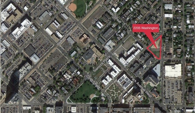
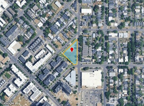
2205 N Washington St, Denver, CO 80205
This Property Is For Sale
NEARBY LISTINGS FOR SALE OR LEASE
-
-
-
-
-
-
-
-
-
-
-
No Photo
-
-
-
-
-
-
-
-
-
-
-
-
-
-
-
View all Denver listings for sale on LoopNet.com
Property Detail
2205 N Washington St
Denver-Aurora-Lakewood, CO
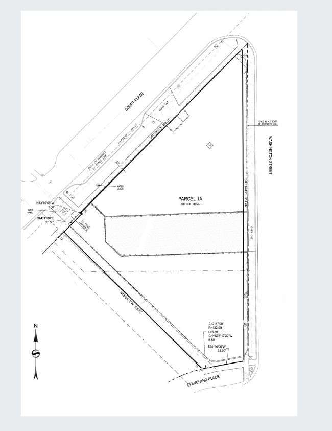
Park Avenue North Flg No 1 B1 L1 Resub O
2341-29-001
PARK AVENUE NORTH FLG NO 1 B1 L1 RESUB OF CLEMENTS ADD BLKS 216,222,223,252 & VAC STREETS
Vacantlandnec
Denver
X
Colorado
0800460201H
1
2024
0.73 AC
2024
Capitol Hill
002300
Denver
DEMOGRAPHICS near 2205 N Washington St
1 Mile
3 Mile
5 Mile
2024 Total Population
45,706
233,475
470,982
2029 Population
46,728
238,168
477,656
Pop Growth 2024-2029
+ 2.24%
+ 2.01%
+ 1.42%
Average Age
37
38
38
2024 Total Households
26,751
125,104
223,768
HH Growth 2024-2029
+ 2.29%
+ 2.04%
+ 1.49%
Median Household Inc
$76,458
$86,905
$85,126
Avg Household Size
1.60
1.80
2.00
2024 Avg HH Vehicles
1.00
1.00
1.00
Median Home Value
$655,454
$706,049
$662,593
Median Year Built
1983
1972
1967
Nearby Places
Map Layers
Map Styles
 Street
 Aerial
- Restaurants
- Banks
- Shops
- Fitness
- Groceries
PUBLIC TRANSPORTATION
TRANSIT/SUBWAY
25th-Welton (D Line - Denver Regional Transportation District Light Rail (TheRide))
DRIVE
WALK
Distance
25th-Welton (D Line - Denver Regional Transportation District Light Rail (TheRide))
1 min
6 min
0.3 mi
27th-Welton (D Line - Denver Regional Transportation District Light Rail (TheRide))
DRIVE
WALK
Distance
27th-Welton (D Line - Denver Regional Transportation District Light Rail (TheRide))
1 min
8 min
0.4 mi
20th-Welton (D Line - Denver Regional Transportation District Light Rail (TheRide))
DRIVE
WALK
Distance
20th-Welton (D Line - Denver Regional Transportation District Light Rail (TheRide))
3 min
11 min
0.6 mi
18th-California (D Line - Denver Regional Transportation District Light Rail (TheRide), F Line - Denver Regional Transportation District Light Rail (TheRide), H Line - Denver Regional Transportation District Light Rail (TheRide))
DRIVE
WALK
Distance
18th-California (D Line - Denver Regional Transportation District Light Rail (TheRide), F Line - Denver Regional Transportation District Light Rail (TheRide), H Line - Denver Regional Transportation District Light Rail (TheRide))
3 min
15 min
0.8 mi
18th-Stout (D Line - Denver Regional Transportation District Light Rail (TheRide), F Line - Denver Regional Transportation District Light Rail (TheRide), H Line - Denver Regional Transportation District Light Rail (TheRide))
DRIVE
WALK
Distance
18th-Stout (D Line - Denver Regional Transportation District Light Rail (TheRide), F Line - Denver Regional Transportation District Light Rail (TheRide), H Line - Denver Regional Transportation District Light Rail (TheRide))
3 min
16 min
0.8 mi
COMMUTER RAIL
DRIVE
WALK
Distance
5 min
1.6 mi
DRIVE
WALK
Distance
13 min
2.8 mi
AIRPORT
Denver International
DRIVE
WALK
Distance
Denver International
34 min
23.4 mi
Nearby Properties
Address
Land Use
TOTAL SIZE
Lot Size
Zoning
Address
Land Use
TOTAL SIZE
Lot Size
Zoning
1,882,179 SF
21.15 AC
D-TD
Address
Land Use
TOTAL SIZE
Lot Size
Zoning
1,721,086 SF
21.34 AC
C-MU-30
Address
Land Use
TOTAL SIZE
Lot Size
Zoning
857,233 SF
10.26 AC
CMP-H
Address
Land Use
TOTAL SIZE
Lot Size
Zoning
794,383 SF
0.90 AC
D-TD
Address
Land Use
TOTAL SIZE
Lot Size
Zoning
1,542,612 SF
1.56 AC
D-C
Address
Land Use
TOTAL SIZE
Lot Size
Zoning
856,519 SF
10.04 AC
B-3
Address
Land Use
TOTAL SIZE
Lot Size
Zoning
1,567,575 SF
1.40 AC
D-C
Address
Land Use
TOTAL SIZE
Lot Size
Zoning
1,096,923 SF
16.14 AC
CMP-H
Address
Land Use
TOTAL SIZE
Lot Size
Zoning
1,312,939 SF
1.15 AC
D-C
Address
Land Use
TOTAL SIZE
Lot Size
Zoning
1,048,471 SF
2.44 AC
PUD
Address
Land Use
TOTAL SIZE
Lot Size
Zoning
545,292 SF
1.15 AC
D-C
Address
Land Use
TOTAL SIZE
Lot Size
Zoning
656,257 SF
3.05 AC
D-CV
Address
Land Use
TOTAL SIZE
Lot Size
Zoning
614,750 SF
0.23 AC
D-C
Address
Land Use
TOTAL SIZE
Lot Size
Zoning
611,828 SF
0.94 AC
PUD
Address
Land Use
TOTAL SIZE
Lot Size
Zoning
150,202 SF
13.24 AC
T-MU-30
Address
Land Use
TOTAL SIZE
Lot Size
Zoning
337,495 SF
0.57 AC
D-C
Address
Land Use
TOTAL SIZE
Lot Size
Zoning
858,528 SF
2.53 AC
D-C
Address
Land Use
TOTAL SIZE
Lot Size
Zoning
755,793 SF
2.44 AC
D-C
Address
Land Use
TOTAL SIZE
Lot Size
Zoning
677,832 SF
2.42 AC
D-C
Address
Land Use
TOTAL SIZE
Lot Size
Zoning
298,387 SF
0.88 AC
PUD
Address
Land Use
TOTAL SIZE
Lot Size
Zoning
724,981 SF
1.26 AC
D-C
Address
Land Use
TOTAL SIZE
Lot Size
Zoning
405,974 SF
1.78 AC
PUD
Address
Land Use
TOTAL SIZE
Lot Size
Zoning
1,018,386 SF
2.46 AC
D-C
Address
Land Use
TOTAL SIZE
Lot Size
Zoning
290,821 SF
1.16 AC
PUD
Address
Land Use
TOTAL SIZE
Lot Size
Zoning
604,358 SF
2.45 AC
D-C
Address
Land Use
TOTAL SIZE
Lot Size
Zoning
716,151 SF
2.45 AC
D-C
Address
Land Use
TOTAL SIZE
Lot Size
Zoning
618,768 SF
1.23 AC
D-C
Address
Land Use
TOTAL SIZE
Lot Size
Zoning
778,340 SF
0.61 AC
D-C
Address
Land Use
TOTAL SIZE
Lot Size
Zoning
334,746 SF
1.25 AC
D-LD
Address
Land Use
TOTAL SIZE
Lot Size
Zoning
764,724 SF
1 AC
D-C
The World's #1 Commercial Real Estate Marketplace
Connect with us
© 2025 CoStar Group
The information above has been obtained from sources believed reliable. While we do not doubt its accuracy we have not verified it and make no guarantee, warranty or representation about it. It is your responsibility to independently confirm its accuracy and completeness. Any projections, opinions, assumptions, or estimates used are for example only and do not represent the current or future performance of the property. The value of this transaction to you depends on tax and other factors which should be evaluated by your tax, financial, and legal advisors. You and your advisors should conduct a careful, independent investigation of the property to determine to your satisfaction the suitability of the property for your needs.