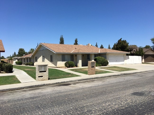
Property Record
2205 Westholme Blvd, Bakersfield, CA 93309


NEARBY LISTINGS FOR SALE OR LEASE
Property Detail
2205 Westholme Blvd
Bakersfield, CA
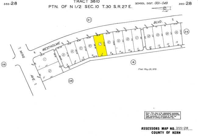
Tract No 3810
355-280-07-00-0
TRACT 3810 , BLOCK , LOT 7
Quadruplex
Kern
X
California
06029C2300E
7
2024
0.28 AC
2025
Sagepointe
002817
Bakersfield
4,345 SF
DEMOGRAPHICS near 2205 Westholme Blvd
1 Mile
3 Mile
5 Mile
2024 Total Population
22,389
140,562
319,096
2029 Population
22,359
140,442
319,241
Pop Growth 2024-2029
(0.13%)
(0.09%)
+ 0.05%
Average Age
36
36
35
2024 Total Households
8,229
47,973
100,677
HH Growth 2024-2029
(0.23%)
(0.13%)
0.00%
Median Household Inc
$51,958
$62,211
$64,928
Avg Household Size
2.70
2.90
3.10
2024 Avg HH Vehicles
2.00
2.00
2.00
Median Home Value
$246,037
$265,810
$287,448
Median Year Built
1975
1978
1984
Nearby Places
Map Layers
Map Styles
 Street
 Aerial
- Restaurants
- Banks
- Shops
- Fitness
- Groceries
PUBLIC TRANSPORTATION
COMMUTER RAIL
Bakersfield (San Joaquins - Amtrak)
DRIVE
WALK
Distance
Bakersfield (San Joaquins - Amtrak)
12 min
5.7 mi
AIRPORT
Meadows Field
DRIVE
WALK
Distance
Meadows Field
20 min
9.7 mi
Freight Ports
The Port of Hueneme
DRIVE
WALK
Distance
The Port of Hueneme
151 min
121.0 mi
SALE & LEASE HISTORY
LISTING DATE
SALE/LEASE

Nov 22, 2022
For Sale
Jun 19, 2018
For Sale
Nearby Properties
Address
Land Use
TOTAL SIZE
Lot Size
Zoning
Address
Land Use
TOTAL SIZE
Lot Size
Zoning
587,976 SF
40.01 AC
M-2
Address
Land Use
TOTAL SIZE
Lot Size
Zoning
60.03 AC
M-3
Address
Land Use
TOTAL SIZE
Lot Size
Zoning
23,615 SF
39.38 AC
C2
Address
Land Use
TOTAL SIZE
Lot Size
Zoning
114,500 SF
12.02 AC
C-2
Address
Land Use
TOTAL SIZE
Lot Size
Zoning
5,850 SF
10.96 AC
C2
Address
Land Use
TOTAL SIZE
Lot Size
Zoning
354,000 SF
20 AC
M2
Address
Land Use
TOTAL SIZE
Lot Size
Zoning
14,529 SF
27.73 AC
R-2
Address
Land Use
TOTAL SIZE
Lot Size
Zoning
241,051 SF
18.48 AC
CO
Address
Land Use
TOTAL SIZE
Lot Size
Zoning
253,532 SF
14.69 AC
Address
Land Use
TOTAL SIZE
Lot Size
Zoning
185,181 SF
14.67 AC
C2
Address
Land Use
TOTAL SIZE
Lot Size
Zoning
269,429 SF
12.71 AC
R-2
Address
Land Use
TOTAL SIZE
Lot Size
Zoning
15,027 SF
17.72 AC
C-2
Address
Land Use
TOTAL SIZE
Lot Size
Zoning
161,539 SF
4 AC
CO
Address
Land Use
TOTAL SIZE
Lot Size
Zoning
37,760 SF
12.16 AC
R3
Address
Land Use
TOTAL SIZE
Lot Size
Zoning
99,368 SF
6.95 AC
CO
Address
Land Use
TOTAL SIZE
Lot Size
Zoning
233,512 SF
9.19 AC
R-3
Address
Land Use
TOTAL SIZE
Lot Size
Zoning
214,746 SF
14.91 AC
Address
Land Use
TOTAL SIZE
Lot Size
Zoning
210,432 SF
13.52 AC
R-2
Address
Land Use
TOTAL SIZE
Lot Size
Zoning
93,274 SF
6.20 AC
R-2
Address
Land Use
TOTAL SIZE
Lot Size
Zoning
55,532 SF
4.18 AC
CO
Address
Land Use
TOTAL SIZE
Lot Size
Zoning
223,557 SF
21.31 AC
PCD
Address
Land Use
TOTAL SIZE
Lot Size
Zoning
83,388 SF
3.15 AC
Address
Land Use
TOTAL SIZE
Lot Size
Zoning
66,849 SF
5.32 AC
CO
Address
Land Use
TOTAL SIZE
Lot Size
Zoning
62,941 SF
8.79 AC
M-1
Address
Land Use
TOTAL SIZE
Lot Size
Zoning
79,325 SF
7.77 AC
C-2
Address
Land Use
TOTAL SIZE
Lot Size
Zoning
71,000 SF
5.89 AC
C-2
Address
Land Use
TOTAL SIZE
Lot Size
Zoning
193,524 SF
2.34 AC
C-O
Address
Land Use
TOTAL SIZE
Lot Size
Zoning
88,988 SF
9.82 AC
C-2
Address
Land Use
TOTAL SIZE
Lot Size
Zoning
140,210 SF
1.74 AC
C-2
The World's #1 Commercial Real Estate Marketplace
Connect with us
© 2025 CoStar Group
The information above has been obtained from sources believed reliable. While we do not doubt its accuracy we have not verified it and make no guarantee, warranty or representation about it. It is your responsibility to independently confirm its accuracy and completeness. Any projections, opinions, assumptions, or estimates used are for example only and do not represent the current or future performance of the property. The value of this transaction to you depends on tax and other factors which should be evaluated by your tax, financial, and legal advisors. You and your advisors should conduct a careful, independent investigation of the property to determine to your satisfaction the suitability of the property for your needs.