Property Record
22063 Pleasant Green Rd, La Monte, MO 65337
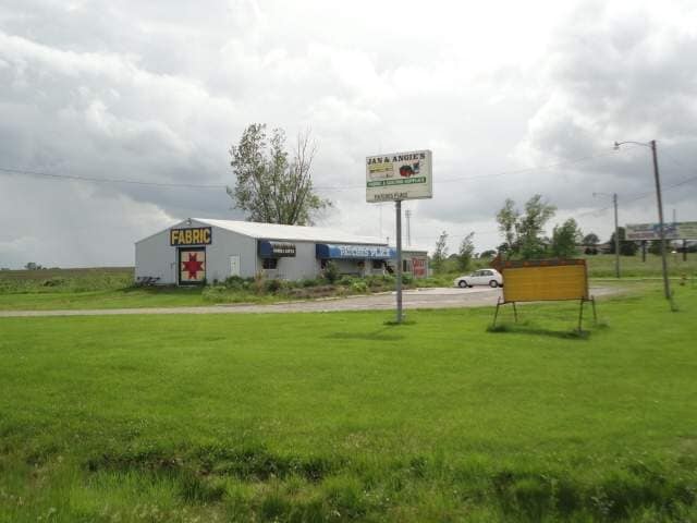

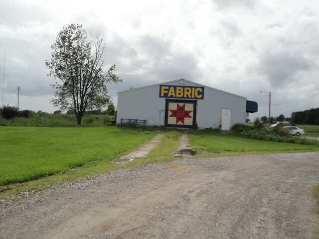
Property Detail
22063 Pleasant Green Rd
Sedalia, MO
BEG 1457.66' E OF E R/W HWY 127 ON S LI N 35A NW & N 330.22' ELY 1084.74' SELY 88.28' S 20' E 9.15' S 288.1' W 1166.14'TO BEG
126023000002000
Pettis
Commercialnec
Missouri
2025
4.86 AC
2025
Missouri North Area
480200
Other Market Areas
12,004 SF
NEARBY LISTINGS FOR SALE OR LEASE
-
-
View all La Monte listings for sale on LoopNet.com
DEMOGRAPHICS near 22063 Pleasant Green Rd
1 mile
3 mile
5 mile
2025 Total Population
989
1,392
2,394
2030 Population
1,014
1,425
2,440
Pop Growth 2025-2030
+ 2.53%
+ 2.37%
+ 1.92%
Average Age
37
38
39
2025 Total Households
346
491
847
HH Growth 2025-2030
+ 2.31%
+ 2.24%
+ 2.01%
Median Household Inc
$61,455
$62,637
$65,118
Avg Household Size
2.70
2.70
2.70
2025 Avg HH Vehicles
2.00
2.00
2.00
Median Home Value
$127,368
$146,153
$183,830
Median Year Built
1969
1971
1976
Nearby Places
Map Layers
Map Styles
 Street
 Aerial
Layers
 Traffic
 Biking
Places
Listings with unknown addresses are not visible on the map
- Restaurants
- Banks
- Shops
- Fitness
- Groceries
SALE & LEASE HISTORY
LISTING DATE
SALE/LEASE

Mar 17, 2020
For Sale
Nearby Properties
Address
Land Use
TOTAL SIZE
Lot Size
Zoning
Address
Land Use
TOTAL SIZE
Lot Size
Zoning
9,100 SF
0.88 AC
Address
Land Use
TOTAL SIZE
Lot Size
Zoning
7,435 SF
0.91 AC
Address
Land Use
TOTAL SIZE
Lot Size
Zoning
7,500 SF
4.04 AC
Address
Land Use
TOTAL SIZE
Lot Size
Zoning
2,216 SF
1.15 AC
Address
Land Use
TOTAL SIZE
Lot Size
Zoning
9,538 SF
2.33 AC
Address
Land Use
TOTAL SIZE
Lot Size
Zoning
3,288 SF
0.98 AC
Address
Land Use
TOTAL SIZE
Lot Size
Zoning
2,828 SF
0.41 AC
Address
Land Use
TOTAL SIZE
Lot Size
Zoning
600 SF
2.07 AC
Address
Land Use
TOTAL SIZE
Lot Size
Zoning
4,284 SF
3.14 AC
Address
Land Use
TOTAL SIZE
Lot Size
Zoning
13,200 SF
3.40 AC
Address
Land Use
TOTAL SIZE
Lot Size
Zoning
5,400 SF
0.33 AC
Address
Land Use
TOTAL SIZE
Lot Size
Zoning
1,560 SF
1.73 AC
Address
Land Use
TOTAL SIZE
Lot Size
Zoning
720 SF
7.25 AC
Address
Land Use
TOTAL SIZE
Lot Size
Zoning
6,000 SF
0.73 AC
Address
Land Use
TOTAL SIZE
Lot Size
Zoning
2,127 SF
250.30 AC
Address
Land Use
TOTAL SIZE
Lot Size
Zoning
6,090 SF
0.67 AC
Address
Land Use
TOTAL SIZE
Lot Size
Zoning
2,324 SF
0.41 AC
Address
Land Use
TOTAL SIZE
Lot Size
Zoning
9,614 SF
1 AC
Address
Land Use
TOTAL SIZE
Lot Size
Zoning
6,384 SF
298 AC
Address
Land Use
TOTAL SIZE
Lot Size
Zoning
2,800 SF
4.13 AC
Address
Land Use
TOTAL SIZE
Lot Size
Zoning
Address
Land Use
TOTAL SIZE
Lot Size
Zoning
1,506 SF
0.23 AC
Address
Land Use
TOTAL SIZE
Lot Size
Zoning
960 SF
0.24 AC
Address
Land Use
TOTAL SIZE
Lot Size
Zoning
Address
Land Use
TOTAL SIZE
Lot Size
Zoning
1,400 SF
0.34 AC
Address
Land Use
TOTAL SIZE
Lot Size
Zoning
5,016 SF
257 AC
Address
Land Use
TOTAL SIZE
Lot Size
Zoning
243.20 AC
Address
Land Use
TOTAL SIZE
Lot Size
Zoning
Address
Land Use
TOTAL SIZE
Lot Size
Zoning
0.67 AC
The World's #1 Commercial Real Estate Marketplace
Connect with us
© 2026 CoStar Group
The information above has been obtained from sources believed reliable. While we do not doubt its accuracy we have not verified it and make no guarantee, warranty or representation about it. It is your responsibility to independently confirm its accuracy and completeness. Any projections, opinions, assumptions, or estimates used are for example only and do not represent the current or future performance of the property. The value of this transaction to you depends on tax and other factors which should be evaluated by your tax, financial, and legal advisors. You and your advisors should conduct a careful, independent investigation of the property to determine to your satisfaction the suitability of the property for your needs.