Property Record
2207 Horseshoe Pike, Honey Brook, PA 19344
This Property Is For Sale
NEARBY LISTINGS FOR SALE OR LEASE
Property Detail
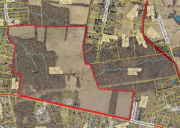
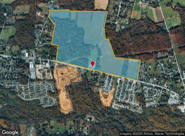
2207 Horseshoe Pike
22-008-0053.0000
133.8 AC
Residentialacreage
Chester
A
Pennsylvania
42029C0080G
133.80 AC
2024
Exton/Whitelands
2025
Philadelphia
304900
Philadelphia-Camden-Wilmington, PA-NJ-DE-MD
DEMOGRAPHICS near 2207 Horseshoe Pike
1 Mile
3 Mile
5 Mile
2024 Total Population
2,745
9,922
31,767
2029 Population
2,893
10,299
32,870
Pop Growth 2024-2029
+ 5.39%
+ 3.80%
+ 3.47%
Average Age
40
43
42
2024 Total Households
984
3,553
11,227
HH Growth 2024-2029
+ 5.59%
+ 3.91%
+ 3.57%
Median Household Inc
$73,610
$88,154
$106,027
Avg Household Size
2.70
2.70
2.80
2024 Avg HH Vehicles
2.00
2.00
2.00
Median Home Value
$83,028
$337,006
$362,430
Median Year Built
1994
1988
1988
Nearby Places
Map Layers
Map Styles
 Street
 Aerial
- Restaurants
- Banks
- Shops
- Fitness
- Groceries
PUBLIC TRANSPORTATION
COMMUTER RAIL
Coatesville Amtrak (Keystone Service - Amtrak)
DRIVE
WALK
Distance
Coatesville Amtrak (Keystone Service - Amtrak)
16 min
8.5 mi
Thorndale (R5 - Southeastern Pennsylvania Transportation Authority Regional Rail (SEPTA Regional Rail))
DRIVE
WALK
Distance
Thorndale (R5 - Southeastern Pennsylvania Transportation Authority Regional Rail (SEPTA Regional Rail))
17 min
8.7 mi
Freight Ports
Port of Wilmington, RI
DRIVE
WALK
Distance
Port of Wilmington, RI
65 min
38.4 mi
Nearby Properties
Address
Land Use
TOTAL SIZE
Lot Size
Zoning
Address
Land Use
TOTAL SIZE
Lot Size
Zoning
136,223 SF
12.60 AC
A
Address
Land Use
TOTAL SIZE
Lot Size
Zoning
249,030 SF
46.40 AC
A
Address
Land Use
TOTAL SIZE
Lot Size
Zoning
142,477 SF
44 AC
R1
Address
Land Use
TOTAL SIZE
Lot Size
Zoning
504,126 SF
53.13 AC
A
Address
Land Use
TOTAL SIZE
Lot Size
Zoning
94,738 SF
25.40 AC
R1
Address
Land Use
TOTAL SIZE
Lot Size
Zoning
44,344 SF
15 AC
R1
Address
Land Use
TOTAL SIZE
Lot Size
Zoning
2,042 SF
20.30 AC
A
Address
Land Use
TOTAL SIZE
Lot Size
Zoning
53.40 AC
LI
Address
Land Use
TOTAL SIZE
Lot Size
Zoning
15,676 SF
16.10 AC
R2
Address
Land Use
TOTAL SIZE
Lot Size
Zoning
35,472 SF
1.50 AC
A
Address
Land Use
TOTAL SIZE
Lot Size
Zoning
7,510 SF
188.79 AC
R3
Address
Land Use
TOTAL SIZE
Lot Size
Zoning
25,114 SF
68 AC
A
Address
Land Use
TOTAL SIZE
Lot Size
Zoning
7,368 SF
139.30 AC
R1
Address
Land Use
TOTAL SIZE
Lot Size
Zoning
5,559 SF
143.32 AC
R1
Address
Land Use
TOTAL SIZE
Lot Size
Zoning
28,302 SF
5.20 AC
LI
Address
Land Use
TOTAL SIZE
Lot Size
Zoning
37,913 SF
10 AC
NC
Address
Land Use
TOTAL SIZE
Lot Size
Zoning
22,061 SF
7.30 AC
R2
Address
Land Use
TOTAL SIZE
Lot Size
Zoning
3,140 SF
166.45 AC
R2
Address
Land Use
TOTAL SIZE
Lot Size
Zoning
4,006 SF
154.31 AC
R2
Address
Land Use
TOTAL SIZE
Lot Size
Zoning
6,538 SF
130 AC
NC
Address
Land Use
TOTAL SIZE
Lot Size
Zoning
9,985 SF
43.37 AC
LI
Address
Land Use
TOTAL SIZE
Lot Size
Zoning
21,979 SF
11.90 AC
LI
Address
Land Use
TOTAL SIZE
Lot Size
Zoning
50,003 SF
4 AC
NC
Address
Land Use
TOTAL SIZE
Lot Size
Zoning
23,942 SF
6.90 AC
NC
Address
Land Use
TOTAL SIZE
Lot Size
Zoning
28,778 SF
6.80 AC
LI
Address
Land Use
TOTAL SIZE
Lot Size
Zoning
19,200 SF
18.50 AC
R2
Address
Land Use
TOTAL SIZE
Lot Size
Zoning
26,291 SF
26 AC
A
Address
Land Use
TOTAL SIZE
Lot Size
Zoning
10,856 SF
2.60 AC
R2
Address
Land Use
TOTAL SIZE
Lot Size
Zoning
17,506 SF
4.40 AC
R1
Address
Land Use
TOTAL SIZE
Lot Size
Zoning
5,880 SF
61.40 AC
A
The World's #1 Commercial Real Estate Marketplace
Connect with us
© 2026 CoStar Group
The information above has been obtained from sources believed reliable. While we do not doubt its accuracy we have not verified it and make no guarantee, warranty or representation about it. It is your responsibility to independently confirm its accuracy and completeness. Any projections, opinions, assumptions, or estimates used are for example only and do not represent the current or future performance of the property. The value of this transaction to you depends on tax and other factors which should be evaluated by your tax, financial, and legal advisors. You and your advisors should conduct a careful, independent investigation of the property to determine to your satisfaction the suitability of the property for your needs.