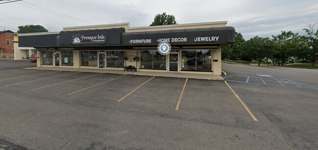
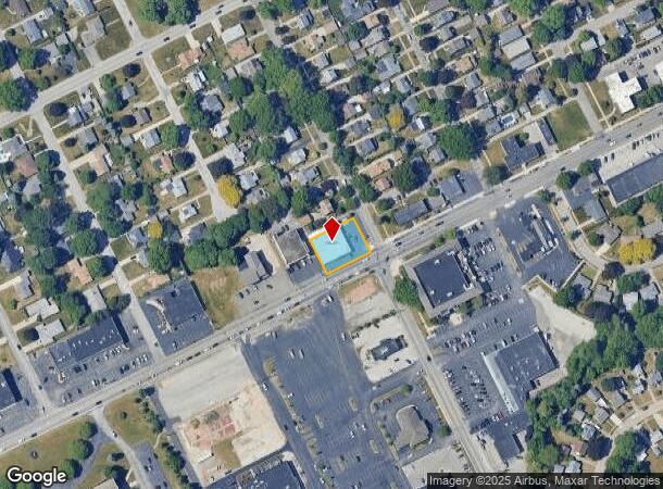
Property Record
2208 W 8Th St, Erie, PA 16505
NEARBY LISTINGS FOR SALE OR LEASE
Property Detail
2208 W 8Th St
33-014-043.0-027.00
2208 W 8 ST 130 X 102.72 IR
Storebuilding
Erie
X
Pennsylvania
42049C0182E
0.30 AC
2025
Outlying Erie County
2025
Erie
012400
Erie, PA
6,970 SF
DEMOGRAPHICS near 2208 W 8Th St
1 Mile
3 Mile
5 Mile
2024 Total Population
5,244
68,184
131,108
2029 Population
5,195
67,576
129,774
Pop Growth 2024-2029
(0.93%)
(0.89%)
(1.02%)
Average Age
47
41
40
2024 Total Households
2,619
30,626
55,049
HH Growth 2024-2029
(1.11%)
(0.98%)
(1.09%)
Median Household Inc
$61,351
$49,992
$50,566
Avg Household Size
2.00
2.10
2.20
2024 Avg HH Vehicles
1.00
1.00
1.00
Median Home Value
$152,979
$132,173
$138,867
Median Year Built
1951
1955
1956
Nearby Places
Map Layers
Map Styles
 Street
 Aerial
- Restaurants
- Banks
- Shops
- Fitness
- Groceries
PUBLIC TRANSPORTATION
AIRPORT
Erie International/Tom Ridge Field
DRIVE
WALK
Distance
Erie International/Tom Ridge Field
7 min
3.2 mi
SALE & LEASE HISTORY
LISTING DATE
SALE/LEASE

Feb 11, 2025
For Lease
Nearby Properties
Address
Land Use
TOTAL SIZE
Lot Size
Zoning
Address
Land Use
TOTAL SIZE
Lot Size
Zoning
583,648 SF
5.55 AC
WC2
Address
Land Use
TOTAL SIZE
Lot Size
Zoning
630,344 SF
7.57 AC
RLB
Address
Land Use
TOTAL SIZE
Lot Size
Zoning
3.38 AC
RLB
Address
Land Use
TOTAL SIZE
Lot Size
Zoning
189,344 SF
2.14 AC
C3
Address
Land Use
TOTAL SIZE
Lot Size
Zoning
24.71 AC
AR
Address
Land Use
TOTAL SIZE
Lot Size
Zoning
138,119 SF
11.39 AC
Address
Land Use
TOTAL SIZE
Lot Size
Zoning
103,358 SF
2.77 AC
WC
Address
Land Use
TOTAL SIZE
Lot Size
Zoning
800 SF
10.05 AC
R2
Address
Land Use
TOTAL SIZE
Lot Size
Zoning
10,960 SF
29.82 AC
DR
Address
Land Use
TOTAL SIZE
Lot Size
Zoning
22.02 AC
AR
Address
Land Use
TOTAL SIZE
Lot Size
Zoning
148,615 SF
19.77 AC
Address
Land Use
TOTAL SIZE
Lot Size
Zoning
1.56 AC
C3
Address
Land Use
TOTAL SIZE
Lot Size
Zoning
117,879 SF
13.47 AC
M1
Address
Land Use
TOTAL SIZE
Lot Size
Zoning
2.45 AC
RLB
Address
Land Use
TOTAL SIZE
Lot Size
Zoning
127,756 SF
7.21 AC
RLB
Address
Land Use
TOTAL SIZE
Lot Size
Zoning
2,754 SF
26.83 AC
DB
Address
Land Use
TOTAL SIZE
Lot Size
Zoning
171,966 SF
13.99 AC
RB
Address
Land Use
TOTAL SIZE
Lot Size
Zoning
65,000 SF
12.11 AC
AB
Address
Land Use
TOTAL SIZE
Lot Size
Zoning
163,596 SF
14.31 AC
C2
Address
Land Use
TOTAL SIZE
Lot Size
Zoning
0.66 AC
C3
Address
Land Use
TOTAL SIZE
Lot Size
Zoning
73,971 SF
1.49 AC
WC
Address
Land Use
TOTAL SIZE
Lot Size
Zoning
10.62 AC
R2
Address
Land Use
TOTAL SIZE
Lot Size
Zoning
88,232 SF
1 AC
RLB
Address
Land Use
TOTAL SIZE
Lot Size
Zoning
100,586 SF
4.89 AC
AB
Address
Land Use
TOTAL SIZE
Lot Size
Zoning
47,635 SF
2.97 AC
R1
Address
Land Use
TOTAL SIZE
Lot Size
Zoning
4,600 SF
50.38 AC
R3
Address
Land Use
TOTAL SIZE
Lot Size
Zoning
108,788 SF
0.74 AC
C3
Address
Land Use
TOTAL SIZE
Lot Size
Zoning
39,948 SF
5.02 AC
BB
Address
Land Use
TOTAL SIZE
Lot Size
Zoning
94,248 SF
2.01 AC
C3
Address
Land Use
TOTAL SIZE
Lot Size
Zoning
0.63 AC
C3
The World's #1 Commercial Real Estate Marketplace
Connect with us
© 2025 CoStar Group
The information above has been obtained from sources believed reliable. While we do not doubt its accuracy we have not verified it and make no guarantee, warranty or representation about it. It is your responsibility to independently confirm its accuracy and completeness. Any projections, opinions, assumptions, or estimates used are for example only and do not represent the current or future performance of the property. The value of this transaction to you depends on tax and other factors which should be evaluated by your tax, financial, and legal advisors. You and your advisors should conduct a careful, independent investigation of the property to determine to your satisfaction the suitability of the property for your needs.