Property Record
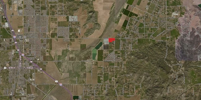
22085 Menifee Rd, Perris, CA 92570
NEARBY LISTINGS FOR SALE OR LEASE
Property Detail
22085 Menifee Rd
Riverside-San Bernardino-Ontario, CA
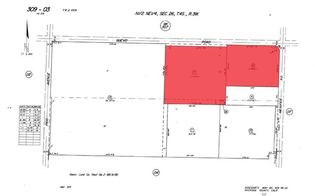
Lands Of Nuevo Land Company Tr 2
309-030-012
10.51 ACRES M/L IN POR LOTS 35 & 36 MB 009/056 LANDS OF NUEVO LAND COMPANY TR 2
Farms
Riverside
AE
California
06065C1445H
36
2024
6.48 AC
2025
Moreno Valley/Perris
042719
Inland Empire (California)
1,464 SF
DEMOGRAPHICS near 22085 Menifee Rd
1 Mile
3 Mile
5 Mile
2024 Total Population
2,804
20,363
95,601
2029 Population
2,923
21,294
100,940
Pop Growth 2024-2029
+ 4.24%
+ 4.57%
+ 5.58%
Average Age
36
34
33
2024 Total Households
738
4,968
23,636
HH Growth 2024-2029
+ 3.66%
+ 4.01%
+ 5.23%
Median Household Inc
$125,168
$89,428
$73,046
Avg Household Size
3.60
3.80
3.80
2024 Avg HH Vehicles
2.00
3.00
3.00
Median Home Value
$461,515
$418,750
$370,533
Median Year Built
1991
1999
1994
Nearby Places
Map Layers
Map Styles
 Street
 Aerial
- Restaurants
- Banks
- Shops
- Fitness
- Groceries
PUBLIC TRANSPORTATION
COMMUTER RAIL
DRIVE
WALK
Distance
10 min
5.3 mi
DRIVE
WALK
Distance
12 min
6.6 mi
AIRPORT
Ontario International
DRIVE
WALK
Distance
Ontario International
46 min
35.6 mi
SALE & LEASE HISTORY
LISTING DATE
SALE/LEASE

Oct 05, 2016
For Sale
Nearby Properties
Address
Land Use
TOTAL SIZE
Lot Size
Zoning
Address
Land Use
TOTAL SIZE
Lot Size
Zoning
7,250 SF
2.35 AC
Address
Land Use
TOTAL SIZE
Lot Size
Zoning
21,029 SF
11.54 AC
A120
Address
Land Use
TOTAL SIZE
Lot Size
Zoning
1,571 SF
66.36 AC
RR
Address
Land Use
TOTAL SIZE
Lot Size
Zoning
4,000 SF
42.83 AC
RA10
Address
Land Use
TOTAL SIZE
Lot Size
Zoning
39.38 AC
RR
Address
Land Use
TOTAL SIZE
Lot Size
Zoning
672 SF
39.38 AC
RR
Address
Land Use
TOTAL SIZE
Lot Size
Zoning
22,772 SF
2.04 AC
CPS
Address
Land Use
TOTAL SIZE
Lot Size
Zoning
19.54 AC
Address
Land Use
TOTAL SIZE
Lot Size
Zoning
9.68 AC
RR
Address
Land Use
TOTAL SIZE
Lot Size
Zoning
5,208 SF
167.88 AC
RR
Address
Land Use
TOTAL SIZE
Lot Size
Zoning
2,784 SF
58.05 AC
RA
Address
Land Use
TOTAL SIZE
Lot Size
Zoning
1,749 SF
6.56 AC
RR
Address
Land Use
TOTAL SIZE
Lot Size
Zoning
7,022 SF
10.05 AC
RA
Address
Land Use
TOTAL SIZE
Lot Size
Zoning
1,000 SF
148.91 AC
RR
Address
Land Use
TOTAL SIZE
Lot Size
Zoning
3,403 SF
9.78 AC
RR
Address
Land Use
TOTAL SIZE
Lot Size
Zoning
1.78 AC
RA
Address
Land Use
TOTAL SIZE
Lot Size
Zoning
5.19 AC
RR
The World's #1 Commercial Real Estate Marketplace
Connect with us
© 2026 CoStar Group
The information above has been obtained from sources believed reliable. While we do not doubt its accuracy we have not verified it and make no guarantee, warranty or representation about it. It is your responsibility to independently confirm its accuracy and completeness. Any projections, opinions, assumptions, or estimates used are for example only and do not represent the current or future performance of the property. The value of this transaction to you depends on tax and other factors which should be evaluated by your tax, financial, and legal advisors. You and your advisors should conduct a careful, independent investigation of the property to determine to your satisfaction the suitability of the property for your needs.