Property Record
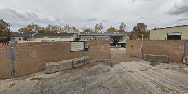
2209 Railroad Ave, Bellwood, IL 60104

This Property Is For Sale
NEARBY LISTINGS FOR SALE OR LEASE
Property Detail
2209 Railroad Ave
Chicago-Naperville-Elgin, IL-IN
Henry C Wilsons Add
15-10-115-051-0000
Cook
Industrialgeneral
Illinois
X
5
17031C0388J
0.54 AC
2023
West Cook North
2025
Chicago
817000
DEMOGRAPHICS near 2209 Railroad Ave
1 Mile
3 Mile
5 Mile
2024 Total Population
24,563
157,634
472,854
2029 Population
23,461
152,683
456,040
Pop Growth 2024-2029
(4.49%)
(3.14%)
(3.56%)
Average Age
37
40
40
2024 Total Households
7,676
56,229
173,976
HH Growth 2024-2029
(4.83%)
(3.40%)
(3.80%)
Median Household Inc
$59,913
$70,253
$75,500
Avg Household Size
3.00
2.70
2.60
2024 Avg HH Vehicles
2.00
2.00
2.00
Median Home Value
$193,557
$236,644
$289,814
Median Year Built
1950
1954
1952
Nearby Places
Map Layers
Map Styles
 Street
 Aerial
- Restaurants
- Banks
- Shops
- Fitness
- Groceries
PUBLIC TRANSPORTATION
COMMUTER RAIL
Melrose Park Station (Union Pacific West Line - Northeast Illinois Regional Commuter Railroad (Metra))
DRIVE
WALK
Distance
Melrose Park Station (Union Pacific West Line - Northeast Illinois Regional Commuter Railroad (Metra))
1 min
7 min
0.4 mi
Bellwood Station (Union Pacific West Line - Northeast Illinois Regional Commuter Railroad (Metra))
DRIVE
WALK
Distance
Bellwood Station (Union Pacific West Line - Northeast Illinois Regional Commuter Railroad (Metra))
3 min
1.6 mi
AIRPORT
Chicago O'Hare International
DRIVE
WALK
Distance
Chicago O'Hare International
18 min
9.7 mi
Chicago Midway International
DRIVE
WALK
Distance
Chicago Midway International
22 min
13.9 mi
Freight Ports
Port Milwaukee
DRIVE
WALK
Distance
Port Milwaukee
102 min
82.1 mi
Nearby Properties
Address
Land Use
TOTAL SIZE
Lot Size
Zoning
Address
Land Use
TOTAL SIZE
Lot Size
Zoning
86.63 AC
Address
Land Use
TOTAL SIZE
Lot Size
Zoning
15.17 AC
Address
Land Use
TOTAL SIZE
Lot Size
Zoning
Address
Land Use
TOTAL SIZE
Lot Size
Zoning
595,800 SF
9.40 AC
Address
Land Use
TOTAL SIZE
Lot Size
Zoning
422,063 SF
18.88 AC
Address
Land Use
TOTAL SIZE
Lot Size
Zoning
Address
Land Use
TOTAL SIZE
Lot Size
Zoning
516,605 SF
16.29 AC
Address
Land Use
TOTAL SIZE
Lot Size
Zoning
790,000 SF
31.71 AC
Address
Land Use
TOTAL SIZE
Lot Size
Zoning
531,227 SF
18.32 AC
Address
Land Use
TOTAL SIZE
Lot Size
Zoning
6.26 AC
Address
Land Use
TOTAL SIZE
Lot Size
Zoning
Address
Land Use
TOTAL SIZE
Lot Size
Zoning
276,458 SF
16.14 AC
Address
Land Use
TOTAL SIZE
Lot Size
Zoning
Address
Land Use
TOTAL SIZE
Lot Size
Zoning
6.57 AC
Address
Land Use
TOTAL SIZE
Lot Size
Zoning
389,155 SF
17.69 AC
Address
Land Use
TOTAL SIZE
Lot Size
Zoning
459,659 SF
Address
Land Use
TOTAL SIZE
Lot Size
Zoning
51.12 AC
Address
Land Use
TOTAL SIZE
Lot Size
Zoning
432,777 SF
22.29 AC
Address
Land Use
TOTAL SIZE
Lot Size
Zoning
184,970 SF
11.64 AC
Address
Land Use
TOTAL SIZE
Lot Size
Zoning
479,130 SF
15.80 AC
Address
Land Use
TOTAL SIZE
Lot Size
Zoning
348,133 SF
2.69 AC
Address
Land Use
TOTAL SIZE
Lot Size
Zoning
108,276 SF
3.80 AC
Address
Land Use
TOTAL SIZE
Lot Size
Zoning
141,800 SF
3.77 AC
Address
Land Use
TOTAL SIZE
Lot Size
Zoning
13.60 AC
Address
Land Use
TOTAL SIZE
Lot Size
Zoning
Address
Land Use
TOTAL SIZE
Lot Size
Zoning
225,000 SF
5.82 AC
Address
Land Use
TOTAL SIZE
Lot Size
Zoning
139,665 SF
11.63 AC
Address
Land Use
TOTAL SIZE
Lot Size
Zoning
1.65 AC
Address
Land Use
TOTAL SIZE
Lot Size
Zoning
15.14 AC
Address
Land Use
TOTAL SIZE
Lot Size
Zoning
13.20 AC
The World's #1 Commercial Real Estate Marketplace
Connect with us
© 2026 CoStar Group
The information above has been obtained from sources believed reliable. While we do not doubt its accuracy we have not verified it and make no guarantee, warranty or representation about it. It is your responsibility to independently confirm its accuracy and completeness. Any projections, opinions, assumptions, or estimates used are for example only and do not represent the current or future performance of the property. The value of this transaction to you depends on tax and other factors which should be evaluated by your tax, financial, and legal advisors. You and your advisors should conduct a careful, independent investigation of the property to determine to your satisfaction the suitability of the property for your needs.