Property Record
22098 Loop 494, New Caney, TX 77357
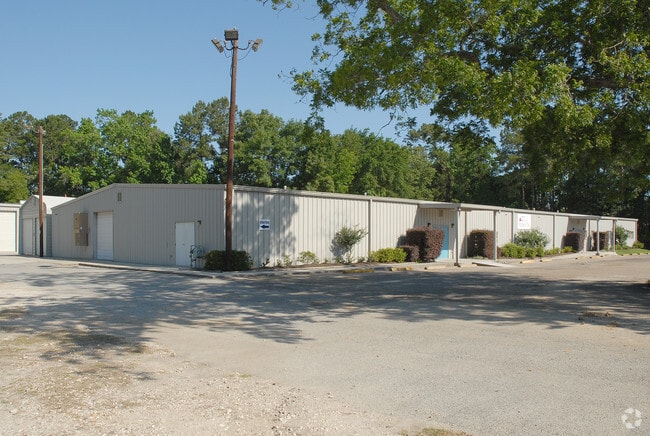

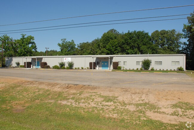
Property Detail
22098 Loop 494
0540-00-00605
S719700 - MISSION NORTHEAST, RES B, ACRES 3.98
Commercialnec
Montgomery
B and X Area of moderate flood hazard, usually the area between the limits of the 100-year and 500-year floods.
Texas
0
3.98 AC
2025
Montgomery County
692501
Houston
19,574 SF
Houston-Pasadena-The Woodlands, TX
NEARBY LISTINGS FOR SALE OR LEASE
DEMOGRAPHICS near 22098 Loop 494
1 mile
3 mile
5 mile
2025 Total Population
5,139
39,612
119,047
2030 Population
6,075
46,839
137,294
Pop Growth 2025-2030
+ 18.21%
+ 18.24%
+ 15.33%
Average Age
34
35
37
2025 Total Households
1,675
13,248
41,144
HH Growth 2025-2030
+ 18.81%
+ 18.86%
+ 15.86%
Median Household Inc
$63,549
$76,988
$91,145
Avg Household Size
3.00
2.90
2.80
2025 Avg HH Vehicles
2.00
2.00
2.00
Median Home Value
$203,720
$244,760
$288,423
Median Year Built
2003
2007
2004
Nearby Places
Map Layers
Map Styles
 Street
 Aerial
Transit
 Traffic
 Biking
Places
Listings with unknown addresses are not visible on the map
- Restaurants
- Banks
- Shops
- Fitness
- Groceries
PUBLIC TRANSPORTATION
AIRPORT
George Bush Intcntl/Houston
Drive
Walk
Distance
George Bush Intcntl/Houston
24 min
17.9 mi
Freight Ports
Port of Houston
Drive
Walk
Distance
Port of Houston
46 min
33.1 mi
Nearby Properties
Address
Land Use
TOTAL SIZE
Lot Size
Zoning
Address
Land Use
TOTAL SIZE
Lot Size
Zoning
430,982 SF
21.50 AC
Address
Land Use
TOTAL SIZE
Lot Size
Zoning
298,715 SF
16.28 AC
Address
Land Use
TOTAL SIZE
Lot Size
Zoning
444,537 SF
55.21 AC
5
Address
Land Use
TOTAL SIZE
Lot Size
Zoning
274,809 SF
11.89 AC
Address
Land Use
TOTAL SIZE
Lot Size
Zoning
29,782 SF
28.69 AC
Address
Land Use
TOTAL SIZE
Lot Size
Zoning
282,880 SF
12.34 AC
Address
Land Use
TOTAL SIZE
Lot Size
Zoning
154,584 SF
46.76 AC
Address
Land Use
TOTAL SIZE
Lot Size
Zoning
356,000 SF
67.95 AC
Address
Land Use
TOTAL SIZE
Lot Size
Zoning
161,302 SF
60.09 AC
5
Address
Land Use
TOTAL SIZE
Lot Size
Zoning
187,696 SF
20.07 AC
Address
Land Use
TOTAL SIZE
Lot Size
Zoning
215,554 SF
20.89 AC
5
Address
Land Use
TOTAL SIZE
Lot Size
Zoning
76,292 SF
32.01 AC
5
Address
Land Use
TOTAL SIZE
Lot Size
Zoning
165,381 SF
16.60 AC
Address
Land Use
TOTAL SIZE
Lot Size
Zoning
224,810 SF
21.64 AC
5
Address
Land Use
TOTAL SIZE
Lot Size
Zoning
38,994 SF
4.82 AC
5
Address
Land Use
TOTAL SIZE
Lot Size
Zoning
121,871 SF
12.59 AC
Address
Land Use
TOTAL SIZE
Lot Size
Zoning
139,838 SF
38.71 AC
Address
Land Use
TOTAL SIZE
Lot Size
Zoning
131,364 SF
4.63 AC
5
Address
Land Use
TOTAL SIZE
Lot Size
Zoning
131,028 SF
9.46 AC
Address
Land Use
TOTAL SIZE
Lot Size
Zoning
98,481 SF
27.47 AC
Address
Land Use
TOTAL SIZE
Lot Size
Zoning
51,659 SF
8.81 AC
Address
Land Use
TOTAL SIZE
Lot Size
Zoning
113,545 SF
10.70 AC
Address
Land Use
TOTAL SIZE
Lot Size
Zoning
109,704 SF
26.81 AC
Address
Land Use
TOTAL SIZE
Lot Size
Zoning
128,724 SF
29.89 AC
Address
Land Use
TOTAL SIZE
Lot Size
Zoning
23.03 AC
5
Address
Land Use
TOTAL SIZE
Lot Size
Zoning
110,013 SF
13.91 AC
5
Address
Land Use
TOTAL SIZE
Lot Size
Zoning
117,146 SF
8.25 AC
5
Address
Land Use
TOTAL SIZE
Lot Size
Zoning
90,142 SF
10.80 AC
5
Address
Land Use
TOTAL SIZE
Lot Size
Zoning
72,839 SF
5.91 AC
The World's #1 Commercial Real Estate Marketplace
Connect with us
© 2026 CoStar Group
The information above has been obtained from sources believed reliable. While we do not doubt its accuracy we have not verified it and make no guarantee, warranty or representation about it. It is your responsibility to independently confirm its accuracy and completeness. Any projections, opinions, assumptions, or estimates used are for example only and do not represent the current or future performance of the property. The value of this transaction to you depends on tax and other factors which should be evaluated by your tax, financial, and legal advisors. You and your advisors should conduct a careful, independent investigation of the property to determine to your satisfaction the suitability of the property for your needs.