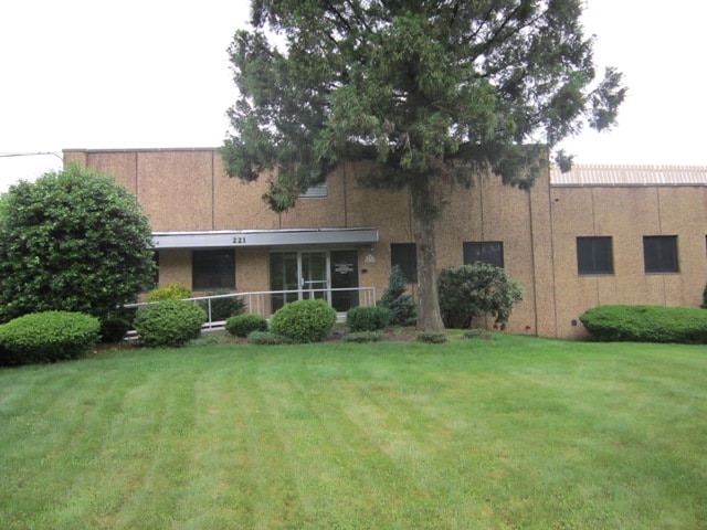
Property Record
221 Stirling Rd, Warren, NJ 07059


Current Lease Availabilities
NEARBY LISTINGS FOR SALE OR LEASE
Property Detail
221 Stirling Rd
20-00160-0000-00009
Somerset
Vacantlandnec
New Jersey
AE
9
34035C0086E
10.62 AC
2024
Somerset
2025
Northern New Jersey
052201
Newark, NJ-PA
37,500 SF
DEMOGRAPHICS near 221 Stirling Rd
1 Mile
3 Mile
5 Mile
2024 Total Population
3,086
29,594
140,385
2029 Population
3,099
29,776
139,198
Pop Growth 2024-2029
+ 0.42%
+ 0.61%
(0.85%)
Average Age
43
43
40
2024 Total Households
1,096
10,334
47,146
HH Growth 2024-2029
+ 0.36%
+ 0.54%
(0.85%)
Median Household Inc
$142,638
$157,931
$113,118
Avg Household Size
2.80
2.80
2.90
2024 Avg HH Vehicles
2.00
2.00
2.00
Median Home Value
$695,616
$710,915
$607,434
Median Year Built
1967
1971
1963
Nearby Places
Map Layers
Map Styles
 Street
 Aerial
- Restaurants
- Banks
- Shops
- Fitness
- Groceries
PUBLIC TRANSPORTATION
COMMUTER RAIL
Stirling (Morris & Essex Gladstone Branch - NJ Transit Commuter Rail (NJ Transit))
DRIVE
WALK
Distance
Stirling (Morris & Essex Gladstone Branch - NJ Transit Commuter Rail (NJ Transit))
4 min
1.4 mi
Gillette (Morris & Essex Gladstone Branch - NJ Transit Commuter Rail (NJ Transit))
DRIVE
WALK
Distance
Gillette (Morris & Essex Gladstone Branch - NJ Transit Commuter Rail (NJ Transit))
3 min
1.5 mi
AIRPORT
Newark Liberty International
DRIVE
WALK
Distance
Newark Liberty International
30 min
22.3 mi
LaGuardia
DRIVE
WALK
Distance
LaGuardia
64 min
41.5 mi
Trenton Mercer
DRIVE
WALK
Distance
Trenton Mercer
74 min
43.8 mi
Freight Ports
Maher Terminal
DRIVE
WALK
Distance
Maher Terminal
34 min
22.9 mi
Nearby Properties
Address
Land Use
TOTAL SIZE
Lot Size
Zoning
Address
Land Use
TOTAL SIZE
Lot Size
Zoning
52.31 AC
OR
Address
Land Use
TOTAL SIZE
Lot Size
Zoning
1,976 SF
22.03 AC
B5
Address
Land Use
TOTAL SIZE
Lot Size
Zoning
34.27 AC
R65
Address
Land Use
TOTAL SIZE
Lot Size
Zoning
67.22 AC
R65
Address
Land Use
TOTAL SIZE
Lot Size
Zoning
23.93 AC
B2
Address
Land Use
TOTAL SIZE
Lot Size
Zoning
Address
Land Use
TOTAL SIZE
Lot Size
Zoning
18.66 AC
CR
Address
Land Use
TOTAL SIZE
Lot Size
Zoning
8.64 AC
AH-4
Address
Land Use
TOTAL SIZE
Lot Size
Zoning
11.66 AC
R6
Address
Land Use
TOTAL SIZE
Lot Size
Zoning
1,096 SF
15.12 AC
R5
Address
Land Use
TOTAL SIZE
Lot Size
Zoning
8.09 AC
B3
Address
Land Use
TOTAL SIZE
Lot Size
Zoning
30.84 AC
OR
Address
Land Use
TOTAL SIZE
Lot Size
Zoning
40.36 AC
OR
Address
Land Use
TOTAL SIZE
Lot Size
Zoning
2,765 SF
9.10 AC
R6
Address
Land Use
TOTAL SIZE
Lot Size
Zoning
40.73 AC
OR
Address
Land Use
TOTAL SIZE
Lot Size
Zoning
1,950 SF
10.56 AC
CR
Address
Land Use
TOTAL SIZE
Lot Size
Zoning
15.73 AC
GI
Address
Land Use
TOTAL SIZE
Lot Size
Zoning
7,670 SF
7 AC
R-R
Address
Land Use
TOTAL SIZE
Lot Size
Zoning
22.61 AC
GI
Address
Land Use
TOTAL SIZE
Lot Size
Zoning
Address
Land Use
TOTAL SIZE
Lot Size
Zoning
1.59 AC
GI
Address
Land Use
TOTAL SIZE
Lot Size
Zoning
2.71 AC
CR
Address
Land Use
TOTAL SIZE
Lot Size
Zoning
Address
Land Use
TOTAL SIZE
Lot Size
Zoning
9.53 AC
DD
Address
Land Use
TOTAL SIZE
Lot Size
Zoning
1.21 AC
GI
Address
Land Use
TOTAL SIZE
Lot Size
Zoning
19.20 AC
GI
Address
Land Use
TOTAL SIZE
Lot Size
Zoning
24.29 AC
GI
Address
Land Use
TOTAL SIZE
Lot Size
Zoning
7.46 AC
BR80
Address
Land Use
TOTAL SIZE
Lot Size
Zoning
6.43 AC
CB
Address
Land Use
TOTAL SIZE
Lot Size
Zoning
23.61 AC
R65
The World's #1 Commercial Real Estate Marketplace
Connect with us
© 2025 CoStar Group
The information above has been obtained from sources believed reliable. While we do not doubt its accuracy we have not verified it and make no guarantee, warranty or representation about it. It is your responsibility to independently confirm its accuracy and completeness. Any projections, opinions, assumptions, or estimates used are for example only and do not represent the current or future performance of the property. The value of this transaction to you depends on tax and other factors which should be evaluated by your tax, financial, and legal advisors. You and your advisors should conduct a careful, independent investigation of the property to determine to your satisfaction the suitability of the property for your needs.