Property Record
221 Boston Post Rd E, Marlborough, MA 01752
NEARBY LISTINGS FOR SALE OR LEASE
Property Detail
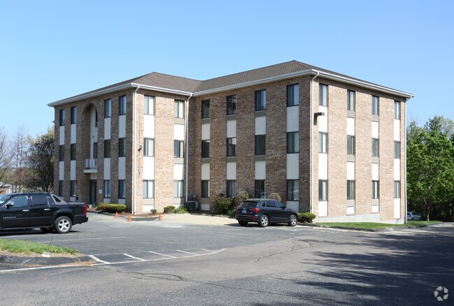
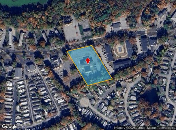
221 Boston Post Rd E
Officebuilding
Middlesex
X
Massachusetts
25017C0482F
2.32 AC
2025
Marlborough
2025
Boston
321200
Boston-Cambridge-Newton, MA-NH
35,077 SF
MARL-000059-000018
DEMOGRAPHICS near 221 Boston Post Rd E
1 Mile
3 Mile
5 Mile
2024 Total Population
11,087
43,328
94,901
2029 Population
11,013
42,757
93,987
Pop Growth 2024-2029
(0.67%)
(1.32%)
(0.96%)
Average Age
40
41
42
2024 Total Households
4,603
17,092
37,424
HH Growth 2024-2029
(0.76%)
(1.35%)
(0.97%)
Median Household Inc
$83,496
$90,860
$105,795
Avg Household Size
2.40
2.50
2.50
2024 Avg HH Vehicles
2.00
2.00
2.00
Median Home Value
$387,139
$448,668
$527,176
Median Year Built
1977
1972
1973
Nearby Places
Map Layers
Map Styles
 Street
 Aerial
- Restaurants
- Banks
- Shops
- Fitness
- Groceries
PUBLIC TRANSPORTATION
COMMUTER RAIL
Southborough (Framingham/Worcester Line - Massachusetts Bay Transportation Authority Commuter Rail (Purple Line))
DRIVE
WALK
Distance
Southborough (Framingham/Worcester Line - Massachusetts Bay Transportation Authority Commuter Rail (Purple Line))
15 min
6.3 mi
Ashland (Framingham/Worcester Line - Massachusetts Bay Transportation Authority Commuter Rail (Purple Line))
DRIVE
WALK
Distance
Ashland (Framingham/Worcester Line - Massachusetts Bay Transportation Authority Commuter Rail (Purple Line))
17 min
8.0 mi
AIRPORT
Worcester Regional
DRIVE
WALK
Distance
Worcester Regional
36 min
23.9 mi
General Edward Lawrence Logan International
DRIVE
WALK
Distance
General Edward Lawrence Logan International
51 min
33.6 mi
Freight Ports
Port of Boston
DRIVE
WALK
Distance
Port of Boston
50 min
31.9 mi
SALE & LEASE HISTORY
LISTING DATE
SALE/LEASE

Oct 30, 2020
For Sale
May 16, 2017
For Lease
May 13, 2019
For Lease
May 08, 2020
For Lease
Jun 15, 2022
For Lease
Jun 14, 2021
For Lease
Jul 16, 2021
For Lease
Jan 02, 2019
For Lease
Feb 21, 2024
For Lease
Dec 16, 2019
For Sale
Nearby Properties
Address
Land Use
TOTAL SIZE
Lot Size
Zoning
Address
Land Use
TOTAL SIZE
Lot Size
Zoning
21.41 AC
LI
Address
Land Use
TOTAL SIZE
Lot Size
Zoning
284,231 SF
62.04 AC
A2
Address
Land Use
TOTAL SIZE
Lot Size
Zoning
23,890 SF
36.39 AC
A3
Address
Land Use
TOTAL SIZE
Lot Size
Zoning
54.67 AC
LI
Address
Land Use
TOTAL SIZE
Lot Size
Zoning
4,188 SF
23.20 AC
B
Address
Land Use
TOTAL SIZE
Lot Size
Zoning
267,805 SF
30.74 AC
A2
Address
Land Use
TOTAL SIZE
Lot Size
Zoning
14.80 AC
M6
Address
Land Use
TOTAL SIZE
Lot Size
Zoning
7,960 SF
17.89 AC
RR
Address
Land Use
TOTAL SIZE
Lot Size
Zoning
157.48 AC
LI
Address
Land Use
TOTAL SIZE
Lot Size
Zoning
188,882 SF
19.37 AC
A3
Address
Land Use
TOTAL SIZE
Lot Size
Zoning
22.74 AC
A1
Address
Land Use
TOTAL SIZE
Lot Size
Zoning
91,722 SF
8.38 AC
A2
Address
Land Use
TOTAL SIZE
Lot Size
Zoning
35,211 SF
89 AC
RA
Address
Land Use
TOTAL SIZE
Lot Size
Zoning
1,976 SF
81.69 AC
RA
Address
Land Use
TOTAL SIZE
Lot Size
Zoning
9.66 AC
A1
Address
Land Use
TOTAL SIZE
Lot Size
Zoning
99,619 SF
1.56 AC
B
Address
Land Use
TOTAL SIZE
Lot Size
Zoning
21.17 AC
A1
Address
Land Use
TOTAL SIZE
Lot Size
Zoning
85,958 SF
13.52 AC
A3
Address
Land Use
TOTAL SIZE
Lot Size
Zoning
10,338 SF
4.76 AC
CA
Address
Land Use
TOTAL SIZE
Lot Size
Zoning
215,936 SF
15.63 AC
I
Address
Land Use
TOTAL SIZE
Lot Size
Zoning
196,145 SF
10.18 AC
LI
Address
Land Use
TOTAL SIZE
Lot Size
Zoning
128,838 SF
4.27 AC
RC
Address
Land Use
TOTAL SIZE
Lot Size
Zoning
182,509 SF
11.35 AC
A2
Address
Land Use
TOTAL SIZE
Lot Size
Zoning
4.65 AC
I
Address
Land Use
TOTAL SIZE
Lot Size
Zoning
71.89 AC
RR
Address
Land Use
TOTAL SIZE
Lot Size
Zoning
3.58 AC
B
Address
Land Use
TOTAL SIZE
Lot Size
Zoning
9.90 AC
C12
Address
Land Use
TOTAL SIZE
Lot Size
Zoning
60,703 SF
4 AC
I
Address
Land Use
TOTAL SIZE
Lot Size
Zoning
116,597 SF
11.29 AC
B
Address
Land Use
TOTAL SIZE
Lot Size
Zoning
148.66 AC
M6
The World's #1 Commercial Real Estate Marketplace
Connect with us
© 2025 CoStar Group
The information above has been obtained from sources believed reliable. While we do not doubt its accuracy we have not verified it and make no guarantee, warranty or representation about it. It is your responsibility to independently confirm its accuracy and completeness. Any projections, opinions, assumptions, or estimates used are for example only and do not represent the current or future performance of the property. The value of this transaction to you depends on tax and other factors which should be evaluated by your tax, financial, and legal advisors. You and your advisors should conduct a careful, independent investigation of the property to determine to your satisfaction the suitability of the property for your needs.